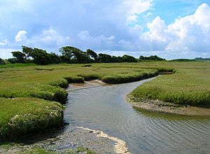
Pagham Harbour facts for kids
| Site of Special Scientific Interest | |
 |
|
| Area of Search | West Sussex |
|---|---|
| Interest | Biological Geological |
| Area | 629.0 hectares (1,554 acres) |
| Notification | 1986 |
| Location map | Magic Map |
Pagham Harbour is a 629-hectare (1,550-acre) biological and geological Site of Special Scientific Interest on the western outskirts of Bognor Regis in West Sussex. It is a Geological Conservation Review site, a Nature Conservation Review site, a Ramsar site, a Special Protection Area and a Marine Conservation Zone. An area of 599.1 hectares (1,480 acres) is a Local Nature Reserve.
The harbour forms an area of saltmarsh and shallow lagoons. It is not an estuary, as no major streams enter the harbour with the only freshwater inflow a few small streams draining surrounding fields.
History
In earlier times Pagham Harbour was a working harbour with three ports. One port was situated at the western end, of the harbour near Sidlesham Mill, and was known as Wardur. The port of Charlton was at the entrance to the harbour and the third was on the Pagham side of the harbour and was known as the Port of Wythering (Wyderinges).
The port of Wardur was part of 'New Haven' a development in the Middle Ages. The Port of Wythering was overrun by the sea in the 13th century and the whole harbour eventually silted up and ceased to be navigable, except for small craft.
An attempt was made to drain the harbour for farming in c. 1873 with an embankment constructed across the edge of the lagoon to hold back the sea; this failed during a storm in December 1910 and was not reconstructed.
At present the entrance to the sea is 50 metres wide.

