
Pago Pago facts for kids
Quick facts for kids
Pago Pago
|
|
|---|---|

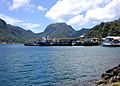
Pago Pago Harbor
|
|
.png)
Pago Pago
Location in central American Samoa

Pago Pago
Location in American Samoa
|
|
| Country | |
| Territory | |
| County | Maoputasi |
| Elevation | 9 m (30 ft) |
| Population
(2010)
|
|
| • Total | 3,656 |
| Time zone | UTC−11 (Samoa Time Zone) |
| ZIP code |
96799
|
| Area code(s) | +1 684 |
| GNIS feature ID | 1389119 |
| Website | www.pagopago.com |
Pago Pago ( PAGO-or-PAGO-or; Samoan:) is the territorial capital of American Samoa. It is in Maoputasi County on Tutuila, which is American Samoa's main island.
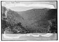
Pago Pago is home to one of the deepest natural deepwater harbors in the South Pacific Ocean, sheltered from wind and rough seas, and strategically located. The harbor is also one of the best protected in the South Pacific, which gives American Samoa a natural advantage because it makes landing fish for processing easier. Tourism, entertainment, food, and tuna canning are its main industries. As of 1993, Pago Pago was the world's fourth-largest tuna processor. It was home to two of the largest tuna companies in the world: Chicken of the Sea and StarKist, which together exported an estimated $445 million in canned tuna to the U.S. mainland. The total value of fish landed in Pago Pago — about $200,000,000 annually — is higher than in any other port in any U.S. state or territory.
Pago Pago is the only modern urban center in American Samoa, and the main port of American Samoa. It is also home to the territorial government, all the industry, and most of the commerce in American Samoa. The Greater Pago Pago Metropolitan Area encompasses several villages strung together along Pago Pago Harbor. One of the villages is itself named Pago Pago, and in 2010 that village had a population of 3,656. The constituent villages are: Utulei, Fagatogo, Malaloa, Pago Pago, Satala and Atu'u. Fagatogo is the downtown area, referred to as "town", and is home to the legislature, while the executive seat is in Utulei. Also in Fagatogo are the Fono, police department, the Port of Pago Pago, and many shops and hotels. In 2000, the Greater Pago Pago area was home to 8,000 residents; by 2010 the population had increased to 15,000.
Rainmaker Mountain (Mount Pioa), which is located in Pago Pago, contributes to a weather pattern that results in the city having the highest annual rainfall of any harbor in the world. It stands protectively over the eastern side of Pago Pago, making the harbor one of the most sheltered deepwater anchorages in the Pacific Ocean.
Historically, the strategic location of Pago Pago Bay played a direct role in the political separation of Western and Eastern Samoa. The initial reason that the U.S. was interested in Tutuila was its desire to use Pago Pago Harbor as a coaling station. The town has the distinction of being the southernmost U.S. capital, and the only one located in the Southern Hemisphere.
Contents
History
From 1878 to 1951, the area was the site of a coaling and repair station for the U.S. Navy, known then as United States Naval Station Tutuila.
In January 1942 Pago Pago Harbor was shelled by a Japanese submarine, but this remained the only battle action on the islands during World War II.
On September 29, 2009, an earthquake struck in the South Pacific, near Samoa and American Samoa, sending a tsunami into Pago Pago and surrounding areas. The tsunami caused moderate to severe damage to villages, buildings and vehicles and caused an unknown number of deaths.
Geography
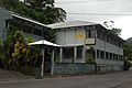
The town is located between steep mountainsides and the harbor. The main downtown area is Fagatogo on the south shore of Pago Pago Harbor, the location of the Fono (territorial legislature), the port, the bus station and the market. The banks are in Utulei and Fagotogo, as are the Sadie Thompson Inn and other hotels. The tuna canneries, which provide employment for a third of the population of Tutuila, are in Atu'u on the north shore of the harbor. The village of Pago Pago is at the western head of the harbor.
A climb to the summit of Mt. Alava in the National Park of American Samoa provides a bird's-eye view of the harbor and town.
Image gallery
-
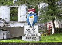
A statue of Starkist Tuna mascot Charlie the Tuna at the company cannery in Atu'u, Pago Pago, American Samoa.
-


Climate
Pago Pago has a tropical rainforest (Köppen climate classification Af) climate. All official climate records for American Samoa are kept at Pago Pago. The hottest temperature ever recorded was 99 °F (37 °C) on February 22, 1958. Conversely, the lowest temperature on record was 59 °F (15 °C) on October 10, 1964.
| Month | Jan | Feb | Mar | Apr | May | Jun | Jul | Aug | Sep | Oct | Nov | Dec | Year |
|---|---|---|---|---|---|---|---|---|---|---|---|---|---|
| Record high °F (°C) | 95 (35) |
99 (37) |
95 (35) |
95 (35) |
93 (34) |
95 (35) |
91 (33) |
92 (33) |
92 (33) |
94 (34) |
95 (35) |
94 (34) |
99 (37) |
| Average high °F (°C) | 87.6 (30.9) |
88.0 (31.1) |
88.1 (31.2) |
87.5 (30.8) |
86.2 (30.1) |
85.0 (29.4) |
84.2 (29.0) |
84.3 (29.1) |
85.3 (29.6) |
85.8 (29.9) |
86.6 (30.3) |
87.4 (30.8) |
86.3 (30.2) |
| Daily mean °F (°C) | 82.6 (28.1) |
82.9 (28.3) |
82.9 (28.3) |
82.5 (28.1) |
81.8 (27.7) |
81.1 (27.3) |
80.4 (26.9) |
80.4 (26.9) |
81.1 (27.3) |
81.5 (27.5) |
82.1 (27.8) |
82.5 (28.1) |
81.8 (27.7) |
| Average low °F (°C) | 77.6 (25.3) |
77.7 (25.4) |
77.8 (25.4) |
77.6 (25.3) |
77.5 (25.3) |
77.1 (25.1) |
76.6 (24.8) |
76.5 (24.7) |
76.9 (24.9) |
77.2 (25.1) |
77.5 (25.3) |
77.6 (25.3) |
77.3 (25.2) |
| Record low °F (°C) | 67 (19) |
65 (18) |
63 (17) |
68 (20) |
65 (18) |
61 (16) |
62 (17) |
60 (16) |
62 (17) |
59 (15) |
60 (16) |
65 (18) |
59 (15) |
| Average precipitation inches (mm) | 14.83 (377) |
12.66 (322) |
11.66 (296) |
11.02 (280) |
10.61 (269) |
6.01 (153) |
6.46 (164) |
6.30 (160) |
7.62 (194) |
10.11 (257) |
11.30 (287) |
14.51 (369) |
123.09 (3,126) |
| Average precipitation days (≥ 0.01 in) | 24.0 | 21.4 | 23.8 | 22.1 | 20.1 | 19.1 | 19.3 | 17.8 | 17.9 | 20.9 | 20.8 | 23.1 | 250.2 |
| Source: NOAA (normals) | |||||||||||||
Tourism

Until 1980, one could experience the view of Mt. Avala by taking an aerial tramway over the harbor, but on April 17 of that year a U.S. Navy plane, flying overhead as part of the Flag Day celebrations, struck the cable; the plane crashed into a wing of the Rainmaker Hotel. The tramway was repaired, but closed not long after. The tram remains unusable, although according to Lonely Planet, plans have been put forth to reopen it, but in December 2010 the cable was damaged by Tropical Cyclone Wilma, fell into the harbor and has not been repaired. Another noted view is that from the top of the pass above Aua Village on the road to Afono.
The Sadie Thompson Inn, on the outskirts of Pago Pago, is a hotel and restaurant that is listed on the U.S. National Register of Historic Places.
Economy

Pago Pago is the center of commerce in American Samoa. It is home to all the industry and most of the commerce in American Samoa. It is the number one port in the United States in terms of value of fish landed - about $200,000,000 per year. In 2007, tuna exports accounted for 93% of all exports, amounting to $446 million.
Tuna canning is the main economic activity in town. Exports are almost exclusively tuna canneries such as Chicken of the Sea and StarKist, which are both located in Pago Pago. These also occupy 14 percent of American Samoa's total workforce as of 2014. The most industrialized area in the territory can be found between Pago Pago Harbor and the Tafuna-Leone Plain, which also are the two most densely populated places in the islands.
American Samoa was the world's fourth-largest tuna processor in 1993. The primary industry is tuna processing by the Samoa Packing Co. (Chicken of the Sea) and StarKist Samoa, a subsidiary of H.J. Heinz. The first cannery was opened in 1954. Canned fish, canned pet food, and fish meal from skin and bones account for 93 percent of American Samoa's industrial output.
Dining establishments, amusement facilities, professional services, and bars can be found throughout Pago Pago. Pago Pago proper was home to 225 registered commercial enterprises as of year 2000. Within the Pago Pago watershed, farmland (faatoaga) are located in two areas in the southern half of the Vaipito Valley as well as in Happy Valley and on the west side of Pago Pago village. Farmland is also found by Fagatogo, Atu'u, Punaoa Valley, Lepua, Aua, and Leloaloa.
Centers for shopping are Pago Plaza, which consists of smaller stores selling handcrafts and souvenirs, and Fagatogo Square Shopping Center, which is home to larger shops. This shopping mall is next-door to Fagatogo Market in Fagatogo, which is considered the main center of Pago Pago. It is home to several restaurants, shops, bars, and often live entertainment and music. Souvenirs are often sold at the market when cruise ships are visiting town. Locals also sell handmade crafts at the dock and on main street. [[Mount ʻAlava]], the canneries in Atu'u, Rainmaker Mountain (Mount Pioa), and Pago Pago Harbor are all visible from the market. The main bus station is located immediately behind the market.
Pago Pago is a duty-free port and prices on imported goods are lower than in other parts of the South Pacific Ocean. Governor H. Rex Lee signed a law making Pago Pago a duty-free port in May 1967.
It is a wealthier city than nearby Apia, capital of Samoa.
Tourism
Tourism in American Samoa is centered around Pago Pago. It receives 34,000 visitors per year, which is one-fourth of neighboring country of Samoa. 69.3 percent of visitors are from the United States as of 2014.
Until 1980, one could experience the view of Mt. Avala by taking an aerial tramway over the harbor, but on April 17 of that year a U.S. Navy plane, flying overhead as part of the Flag Day celebrations, struck the cable; the plane crashed into a wing of the Rainmaker Hotel. The tramway was repaired, but closed not long after. The tram remains unusable, although according to Lonely Planet, plans have been put forth to reopen it, but in December 2010 the cable was damaged by Tropical Cyclone Wilma, fell into the harbor and has not been repaired. Governor Lolo Matalasi Moliga announced in 2014 that he would look into restoring the cable car.
Another noted view is that from the top of the pass above Aua Village on the road to Afono.
The Sadie Thompson Inn, on the outskirts of Pago Pago, is a hotel and restaurant that is listed on the U.S. National Register of Historic Places.
The Greater Pago Pago Area is home to more than 10 hotels:
- Rainmaker Hotel, the largest hotel on Tutuila Island (Demolished in 2015)
- Quality Inn Tradewinds Hotel, located by the airport at Ottoville
- Sadie Thompson Inn, named for a character in Rain (1921), in Fagatogo
- Herb and Sia's Motel, in downtown area of Fagatogo
- Scanlan Inn, a smaller motel in Fagatogo
- Motu O Fiafiaga Motel (Evalani's Motel), in Fagatogo
- Sadies by the Sea, hotel in 'Utulei
Demographics

The village of Pago Pago proper had a 2010 population of 3,656. However, Pago Pago also encompasses neighboring villages. The Greater Pago Pago Area was home to 11,500 residents in 2011. Around 90 percent of American Samoa's population lives around Pago Pago. American Samoa's population grew by 22 percent in the 1990s; nearly all of this growth took place in Pago Pago.
As of the 2000 U.S. Census, 74.5% of Pago Pago's population are of "Native Hawaiian or Other Pacific Island" race. 16.6% were Asian, while 4.9% were white. In Pago Pago proper, residential communities are mostly found in the Vaipito Valley.
The proportion of Pago Pago residents born outside of American Samoa was 26 percent in the early 1980s, and 39 percent in the late 1980s. The percentage of residents born abroad reached 44 percent in 1990. Many of the residents are American Samoans who were born abroad, and the village also has had an increasing number of new residents from Far East countries such as South Korea.
Education
The Feleti Barstow Public Library is located in Pago Pago. In 1991, severe tropical cyclone Val hit Pago Pago, destroying the library that existed there. The current Barstow library, constructed in 1998, opened on April 17, 2000.
The American Samoa Community College (ASCC) was founded in July 1970 by the American Samoa Department of Education. The college's first courses were taught in 1971 at the Lands and Survey Building in Fagatogo. At the time, the college had a total enrollment of 131 students. In 1972, the college moved to the former Fialloa High School in Utulei, before ultimately moving to its current location in Mapusaga in 1974.
Transportation


Pago Pago Harbor is the port of entry for vessels arriving in American Samoa. Many cruise boats and ships land at Pago Pago Harbor for reprovision reasons, such as to restock on goods and to utilize American-trained medical personnel. Pago Pago Harbor is one of the world's largest natural harbors. It has been named one of the best deepwater harbors in the South Pacific Ocean, or one of the best in the world as a whole.
Pago Pago is a port of call for South Pacific cruise ships, including Norwegian Cruise Line and Princess Cruises. However, cruise ships do not take on passengers in Pago Pago, but typically arrive in the morning and depart in the afternoon. Thirteen cruise ships were scheduled to visit Pago Pago in 2017, bringing 31,000 visitors. Pago Pago Harbor can accommodate two cruise ships at the same time, and has done so on several occasions.
Pago Pago International Airport (PPG) is located at Tafuna, eight miles (13 km) southwest of Pago Pago. There are international flights to Samoa 4–7 times daily by Polynesian Airlines: Pago Pago is a 35-minute flight from Apia in Samoa. Most flights are to and from Fagali'i. There is only one flight destination from the territory to the United States: Honolulu International Airport, a five-hour flight from Pago Pago by Hawaiian Airlines. Of the 88,650 international arrivals in 2001, only 10 percent were tourists. The rest came to visit relatives, for employment reasons, or in transit. Most international visitors are from the independent country of Samoa.
Scheduled intra-territorial flights are available to the islands of Taʻū and Ofu, which take 30 minutes by air from Pago Pago.
A ferry called MV Lady Naomi runs between Pago Pago and Apia, Samoa, once a week.
Bus and taxi services are based in Fagatogo.
Notable people

- Peter Tali Coleman, 43rd, 51st, and 53rd Governor of American Samoa
- Al Harrington, actor most known for his role in Hawaii Five-O
- Gary Scott Thompson, director and television producer
- John Kneubuhl, screenwriter
- Shalom Luani, NFL player for the Los Angeles Chargers
- Junior Siavii, Former NFL player for the Kansas City Chiefs, Dallas Cowboys, and the Seattle Seahawks
- Jonathan Fanene, Former NFL player for the Cincinnati Bengals
- Mosi Tatupu, Former NFL player for the New England Patriots, and the Los Angeles Rams
- Shaun Nua, Former NFL player for the Pittsburgh Steelers
- Isaac Sopoaga, Former NFL player for the San Francisco 49ers, Philadelphia Eagles, New England Patriots, and the Arizona Cardinals
- [[Daniel Teʻo-Nesheim]], Former NFL player for the Philadelphia Eagles, and the Tampa Bay Buccaneers
- Kennedy Polamalu, football coach
- Frank Solomon, rugby player
- Faauuga Muagututia, US Navy Seal
- Amata Coleman Radewagen, Delegate in the U.S. House of Representatives
- Fofó Iosefa Fiti Sunia, first non-voting Delegate from American Samoa to the U.S. House of Representatives
- Louisa Mavaega, women's footballer
- Rawlston Masaniai, soccer player
- Palauni Ma Sun, American football offensive lineman
- Joey Iosefa, football player
- Bob Apisa, football player
- Domata Peko, football player
- Isaako Aaitui, football player
- Ramin Ott, player for the American Samoa national football team
- Kennedy Polamalu, football coach and former player
- Gabe Reid, former football tight end for the NFL's Chicago Bears
- Nicky Salapu, soccer player
- Trevor Misipeka, football player
- Frank Solomon, rugby player
- Cocoa Samoa, wrestler
- Mighty Mo, kickboxer
Images for kids
-
From 1878 to 1951, it was a coaling and repair station for the U.S. Navy, known as US Naval Station Tutuila.
-
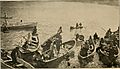
Boatmen in Pago Pago, 1907
-
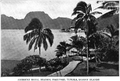
Pago Pago as seen in the early 1900s
-
English author W. Somerset Maugham stayed at Sadie Thompson Inn during his 6-week visit to Pago Pago in 1916.
-
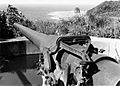
Guns were emplaced at Blunts and Breakers Points in 1940–42, covering Pago Pago Harbor.
-
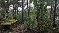
Remains of a World War II encampment above Utulei.
-
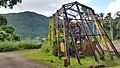
The historic tramway on the World War II Heritage Trail
-
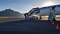
Pago Pago International Airport
-
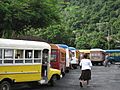
2007 Annual Pago Pago Championship Busfest
-
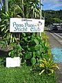
Pago Pago Yacht Club
-
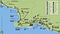
NPS map of Pago Pago
-
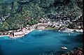
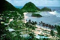
Pago Pago Harbor
-
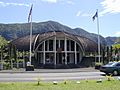
The Fono (legislature) is located in Fagatogo, which is the center of town.
-
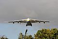
National Park of American Samoa is accessed through Pago Pago International Airport.
-
At 1,716 ft (523 m), Rainmaker Mountain gives the city the highest annual rainfall of any harbor in the world.
-
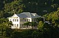
Government House, on the Togotogo Ridge, appears on the National Register of Historic Places.
-
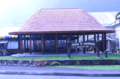
Fale outside Jean P. Haydon Museum

_(14780577521).jpg)


See also
 In Spanish: Pago Pago para niños
