
Palisades del Rey, California facts for kids
Quick facts for kids
Palisades del Rey
Surfridge
|
|
|---|---|
|
Former settlement
|
|

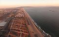
Abandoned streets of Palisades del Rey, visible to the left of Los Angeles International Airport
|
|

Palisades del Rey
Location in California
|
|
| Country | United States |
| State | California |
| County | Los Angeles County |
| City | Los Angeles |
| Elevation | 135 ft (41 m) |
Palisades del Rey (Spanish for "Palisades of the King") was a 1921 neighborhood land development by Dickinson & Gillespie Co. that later came to be called the Playa del Rey district of Los Angeles County, California. It lay at an elevation of 135 feet (41 m). All of the houses in this area were custom built, many as beach homes owned by Hollywood actors and producers, including Cecil B. DeMille, Charles Bickford, and others.
A southern portion of Playa del Rey became known as Surfridge. It was south of the current remaining area of Playa del Rey and north of El Segundo and immediately west of the perimeter of Los Angeles International Airport (LAX). The area is bounded on the east by LAX, on the north by Waterview and Napoleon streets, on the south by Imperial Highway, and on the west by Vista del Mar. The beach to the west of the area is Dockweiler State Beach.
The development
Surfridge was developed in the 1920s and 1930s as "an isolated playground for the wealthy." In 1925 the developer held a contest to name the neighborhood and awarded the $1,000 prize to an Angeleno who submitted "Surfridge." The Los Angeles Times wrote that Surfridge was chosen "due to its brevity, euphony, ease of pronunciation ... but above all because it tells the story of this new wonder city."
Salesmen pitched tents on the sand dunes and sold lots for $50 down and 36 monthly payments of $20. House exteriors could only be stucco, brick or stone; frame structures were prohibited. Development was slowed by the onset of the Great Depression, but in the early 1930s the wealthy began to buy lots to build large homes.
The airport
A small airfield opened to the east of Surfridge in 1928. It became a popular location for residents to see air shows.
The growing number of commercial flights into Los Angeles following after World War II meant a higher number of planes flying low over Surfridge. Many residents learned to co-exist with the noise from propeller planes, but jet engines were impossible to ignore.
"If you lived in Surfridge prior to the late 1950s, you had to raise your voice a bit when having a conversation. After the jets came, you had to literally stop talking when they took off," said Duke Dukesherer, a business executive who has written about Surfridge's history.
In the 1960s and 1970s, the area was condemned and acquired by the City of Los Angeles in a series of eminent domain purchases to facilitate airport expansion and to address concerns about noise from jet airplanes. Home owners were forced to sell their property to the city. Several homeowners sued the city and remained in their houses for several years after the majority of houses were vacated. Eventually all the houses were either moved or demolished.
Today one can see only barbed-wire fences protecting vacant land and old streets where houses once sat. The area is now the protected habitat for the endangered El Segundo blue butterfly.
Images for kids
-
Aerial view of El Segundo and the area formerly known as Surfridge

