
Palmas, Tocantins facts for kids
Quick facts for kids
Palmas
|
|||
|---|---|---|---|
|
Municipality
|
|||
| Município de Palmas Municipality of Palmas |
|||

Top left:A monument of Coluna Prestes in the Sunflower Square, Top right: Sunflower Square (Graciosa Beach), Center:A view of Palmas Tocantins Bridge and Palmas, Bottom left:Ponte do Fernando Henrique Cardoso (Fernando Henrique Cardoso Bridge) and Tocantins River, Bottom right:Palacio Araguaia (Araguaia Palace)
|
|||
|
|||
| Nickname(s):
Capital Ecológica (Ecological Capital)
|
|||
| Motto(s):
Essa terra é nossa (This Land is Ours)
|
|||

Localization of Palmas in Tocantins
|
|||

Palmas
Location in Brazil
|
|||
| Country | |||
| Region | North | ||
| State | |||
| Founded | May 20, 1989 | ||
| Area | |||
| • Total | 2,218.93 km2 (856.73 sq mi) | ||
| Elevation | 230 m (755 ft) | ||
| Population
(2017)
|
|||
| • Total | 286,787 | ||
| • Density | 129,24/km2 (33,470/sq mi) | ||
| Demonym(s) | Palmense | ||
| Time zone | UTC-3 | ||
| Postal Code (CEP) |
From 77000-001 to 77249-999
|
||
| Area code(s) | +55 63 | ||
| Website | www.palmas.to.gov.br | ||


Palmas ( Palm trees) is the capital and largest city in the state of Tocantins, Brazil, newly organized under the 1988 constitution. According to IBGE estimates from 2017, the city had 286,787 inhabitants.
Palmas is located at the state geographic centre at an average altitude of 230 m (755 ft). The city is located between these hills and the Tocantins River. In the east, Palmas is bordered by the Serra do Lajeado. Palmas has a metropolitan area with 471,639 inhabitants on the side of Palmas Lake.
Palmas was founded in 1990 and developed from the ground up in a former agricultural area as the capital of the newest Brazilian state Tocantins. This was organized under the new 1988 Brazilian Constitution. It was intended to develop a relatively undeveloped area of the nation to provide better jobs for people. The city has a well-designed road system, and its urban zoning is modeled on that of Brasília, the capital. In Palmas a symmetrical park was developed at the city centre. The Federal University of Tocantins was established here in the late 20th century, at the time of other development.
In 2002, the Lajeado Hydroelectric Power Plant reservoir was completed, at which point the city gained many river beaches on its lake shore. The project included construction of a huge bridge, the Ponte da Amizade Presidente Fernando Henrique Cardoso, which crosses over 8 kilometers (5.0 mi) over the reservoir, connecting Palmas with the major highway BR-153.
The Palmas Airport connects Palmas with many Brazilian cities.
Images for kids
-
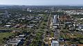
View of Palmas.
-

A commercial center in Palmas.
-
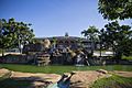
Girassóis Square in Palmas.
-
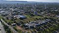
Aerial view of Palmas.
-
Government House of Tocantins.
-
A public hospital in Palmas.
-
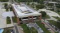
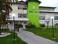
Federal University of Tocantins Fire Monitoring Center.
-
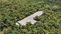
Palmas Airport.
-
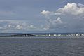
Fernando Henrique Cardoso Bridge and Tocantins River.


_-_UFT.jpg)


See also
 In Spanish: Palmas (Tocantins) para niños
