Palmyra Township, Portage County, Ohio facts for kids
Quick facts for kids
Palmyra Township, Portage County, Ohio
|
|
|---|---|

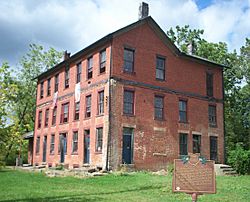
The three-story Stagecoach stop at the center of town.
|
|

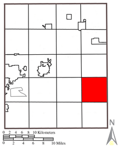
Location within Portage County
|
|
| Country | United States |
| State | Ohio |
| County | Portage |
| Area | |
| • Total | 25.6 sq mi (66.4 km2) |
| • Land | 25.6 sq mi (66.4 km2) |
| • Water | 0.0 sq mi (0.0 km2) |
| Elevation | 1,040 ft (317 m) |
| Population
(2000)
|
|
| • Total | 2,785 |
| • Density | 108.6/sq mi (41.9/km2) |
| Time zone | UTC-5 (Eastern (EST)) |
| • Summer (DST) | UTC-4 (EDT) |
| FIPS code | 39-59668 |
| GNIS feature ID | 1086834 |
Palmyra Township is one of the eighteen townships of Portage County, Ohio, United States. The 2000 census found 2,785 people in the township.
Contents
Geography
Located in the southeastern part of the county, it borders the following townships:
- Paris Township - north
- Newton Township, Trumbull County - northeast corner
- Milton Township, Mahoning County - east
- Berlin Township, Mahoning County - southeast corner
- Deerfield Township - south
- Atwater Township - southwest corner
- Edinburg Township - west
- Charlestown Township - northwest corner
No municipalities are located in Palmyra Township, although the unincorporated community of Diamond lies in the township's east.
Formed from the Connecticut Western Reserve, Palmyra Township covers an area of 26 square miles (67 km2).
Name and history
It is the only Palmyra Township statewide. A post office called Palmyra was established in 1807, and remained in operation until 1904. The community most likely was named after Palmyra, New York. In the mid-1880s, Palmyra contained several factories, stores, and three saloons.
Education
Palmyra Township is served by the Southeast Local Schools, and Southeast High School is located in the township.
See also
 In Spanish: Municipio de Palmyra (condado de Portage, Ohio) para niños


