
Panama City Beach, Florida facts for kids
Quick facts for kids
Panama City Beach, Florida
|
|||
|---|---|---|---|
.jpg)
View of the beach looking northwest from St. Andrews State Park
|
|||
|
|||
| Nickname(s):
PCB, Capital of Redneck Riviera
|
|||
| Motto(s):
The World's Most Beautiful Beaches
|
|||

Location in Bay County and the state of Florida
|
|||
| Country | |||
| State | |||
| County | |||
| Incorporated | 1970 | ||
| Area | |||
| • Total | 19.53 sq mi (50.57 km2) | ||
| • Land | 19.32 sq mi (50.05 km2) | ||
| • Water | 0.20 sq mi (0.52 km2) | ||
| Elevation | 10 ft (3 m) | ||
| Population
(2020)
|
|||
| • Total | 18,094 | ||
| • Density | 936.40/sq mi (361.55/km2) | ||
| Time zone | UTC−06:00 (Central (CST)) | ||
| • Summer (DST) | UTC−05:00 (CDT) | ||
| ZIP |
32401, 32407, 32408, 32413, 32417
|
||
| Area code(s) | 850 | ||
| FIPS code | 12-54725 | ||
| GNIS feature ID | 0308451 | ||


Panama City Beach is a resort town in Bay County, Florida, United States, on the Gulf of Mexico coast. As of the 2010 census it had a population of 12,018. The city is often referred to under the umbrella term of "Panama City". Panama City Beach's slogan is "The World's Most Beautiful Beaches" due to the unique, sugar-white sandy beaches of northwest Florida.
Panama City Beach is a popular vacation destination, especially among people in the Southern United States. The city is also a popular spring break destination, due to its beach and proximity to most of the Southern United States. The first two seasons of MTV’s Floribama Shore were filmed in the city.
Contents
Geography
Panama City Beach is located at 30°12′27″N 85°51′5″W / 30.20750°N 85.85139°W (30.207362, -85.851485). According to the United States Census Bureau, the city has a total area of 18.6 square miles (48.2 km2)— 18.4 square miles (47.6 km2) is land and 0.23 square miles (0.6 km2) (1.17%) is water. There are approximately 9 miles (14 km) of shoreline in Panama City Beach fronting the Gulf of Mexico.
Demographics
| Historical population | |||
|---|---|---|---|
| Census | Pop. | %± | |
| 1960 | 36 | — | |
| 1970 | 67 | 86.1% | |
| 1980 | 2,148 | 3,106.0% | |
| 1990 | 4,051 | 88.6% | |
| 2000 | 7,671 | 89.4% | |
| 2010 | 12,018 | 56.7% | |
| 2020 | 18,094 | 50.6% | |
| U.S. Decennial Census | |||
As of the census of 2010, there were 12,018 people, 5,417 households, and 3,068 families residing in the city. The population density was 653.2 persons per square mile (252.5/km2). There were 17,141 housing units at an average density of 931.6 houses per square mile (360.1/km2). The racial makeup of the city was 89.5% White, 2.3% African American, 0.6% American Indian or Alaska Native, 2.7% Asian and 3.1% from two or more races. Hispanic or Latino of any race were 5.8% of the population.
There were 5,417 households, out of which 21.1% had children under the age of 18 living with them, 42.9% were headed by married couples living together, 9.2% had a female householder with no husband present, and 43.4% were non-families. 31.3% of all households were made up of individuals, and 9.5% were someone living alone who was 65 years of age or older. The average household size was 2.22, and the average family size was 2.76.
In the city, the population was spread out, with 18.0% under the age of 18, 10.3% from 18 to 24, 27.2% from 25 to 44, 29.0% from 45 to 64, and 15.5% who were 65 years of age or older. The median age was 40.9 years. For every 100 females, there were 99.6 males. For every 100 females age 18 and over, there were 100.0 males.
Ancestries: English (17.7%), German (17.4%), Irish (14.8%), United States (11.1%), Italian (3.6%), French (3.1%).
At the 2000 census, the median income for a household in the city was $41,198, and the median income for a family was $49,127. Males had a median income of $32,459 versus $22,358 for females. The per capita income for the city was $26,734. About 2.2% of families and 5.0% of the population were below the poverty line, including 3.9% of those under age 18 and 4.5% of those age 65 or over.
Transportation
The new Northwest Florida Beaches International Airport provides commercial flights into the area. The airport serves private aircraft, domestic passenger flights, and freight/cargo flights. It is the first international airport to be constructed after the September 11 terrorist attacks. Other modes of transportation include scooters, which can be rented by the day, as well as taxi and shuttle companies, which are permitted by the local police.
Panama City Beach also has a road trolley system available which runs hourly. The Bay Town Trolley system runs throughout the county giving its tourists and locals the resource they need to get around Bay County.
Major highways
 US 98 is an east-west highway running along the Gulf Coast. It is the main route to Destin and to Panama City proper.
 State Road 79 is a north-south highway that starts in Panama City Beach and heads north to Interstate 10 and on to the Alabama state line.
 State Road 30, formerly US 98 Alt, also named Front Beach Road, is an east-west highway that runs mostly along the beach front, beginning and ending at US 98.
Recreation
- Frank Brown Park
Gallery

-
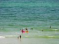
The city lies on Florida's "Emerald Coast" of the Gulf of Mexico
-
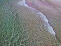
Clear waters as seen from Pier Park's pier
-
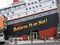
"Ripley's Believe it or Not!" museum, a tourist attraction
-
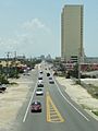
Looking down on Front Beach Road


Sports
The city was home to the Panama City Beach Pirates, a fourth-division soccer team from 2007–2015.
It is also notable that World Championship Wrestling held their last WCW Nitro event in Panama City Beach. WCW was bought out by their rival competition WWF (now WWE).
Education
Primary and secondary public education is provided by the Bay District Schools (BDS).
The Gulf Coast State College is located in Panama City, just across the Hathaway Bridge from Panama City Beach.
The Florida State University Panama City branch campus is also located in Panama City, just across the Hathaway Bridge from Panama City Beach.
See also
 In Spanish: Panama City Beach para niños
