
Paso Robles, California facts for kids
Quick facts for kids
Paso Robles, California
|
|||
|---|---|---|---|
| City of El Paso de Robles | |||

Overlooking southern Paso Robles
|
|||
|
|||
| Nickname(s):
Paso
|
|||
_Highlighted_0622300.svg)
Location of El Paso de Robles (Paso Robles) in San Luis Obispo County, California
|
|||

Paso Robles, California
Location in the United States
|
|||
| Country | United States | ||
| State | California | ||
| County | San Luis Obispo | ||
| Incorporated | March 11, 1889 | ||
| Named for | The Pass of the Oaks | ||
| Government | |||
| • Type | Council–manager | ||
| • Body | El Paso de Robles City Council | ||
| Area | |||
| • Total | 19.66 sq mi (50.92 km2) | ||
| • Land | 19.65 sq mi (50.89 km2) | ||
| • Water | 0.01 sq mi (0.03 km2) 1.57% | ||
| Elevation | 732 ft (223 m) | ||
| Population
(2010)
|
|||
| • Total | 29,793 | ||
| • Estimate
(2019)
|
32,153 | ||
| • Density | 1,636.37/sq mi (631.81/km2) | ||
| Time zone | UTC−8 (Pacific) | ||
| • Summer (DST) | UTC−7 (PDT) | ||
| ZIP codes |
93446, 93447
|
||
| Area code | 805/820 | ||
| FIPS code | 06-22300 | ||
| GNIS feature IDs | 254139, 2410415 | ||


Paso Robles ( pass-OH-_-ROH-buulz), officially El Paso de Robles (Spanish for "The Pass of Oaks"), is a city in San Luis Obispo County, California, United States. Located on the Salinas River north of San Luis Obispo, California, the city is known for its hot springs, its abundance of wineries, its production of olive oil, almond orchards, and for playing host to the California Mid-State Fair.
Contents
Geography
Paso Robles is located at 35°37′36″N 120°41′24″W / 35.62667°N 120.69000°W, approximately halfway between the cities of Los Angeles and San Francisco. Paso Robles is where the region of Southern California ends. The elevation of Paso Robles ranges from 675 to 1,100 feet (340 m), but the majority of the main downtown area of the city sits at about 740 feet (230 m) above sea level. According to the United States Census Bureau, the Paso Robles city limits contain a total land area of 19.4 sq mi (50.3 km2), 98.43% of it land and 1.57% of it water.
The topography of the area consists of gentle rolling hills on the eastern half of the city, and foothill peaks which rise in elevation to the Santa Lucia Coastal Range on the west, which are all blanketed in the Californian chaparral environment, which is mainly dry grassland and oak woodland. Simply "Paso," as it is referred to by locals, sits on the eastern foothills of the Santa Lucia Coastal Mountain Range, which lies directly to the West of the city, and runs in a North-South direction, starting at Monterey, then runs down South to its terminus, in the San Luis Obispo area. The city is located at the southern end of the fertile Salinas River Valley, which is centered in between the Temblor Range (including the San Andreas Fault), which lie about 28 miles (45 km) to the East, and the Santa Lucia Coastal Range, which lie directly west, rising up from the city's western border. Paso Robles sits at the border where northern San Luis Obispo County and southern Monterey County meet, and is situated roughly 24 miles (39 km), or 20 minutes, inland from the Pacific Ocean.

Climate
The Paso Robles area actually consists of two different climate types and classifications, as based on the Köppen climate classification (KCC) system, which are KCC type BSk, a semi-arid, dry, steppe-type climate, and KCC type Csb, which is the typical, coastal Californian & 'Mediterranean' type. The area receives a mixture of these two types of climates, but the primary climate is defined by long, hot, dry summers and brief, cool, sometimes rainy winters. Paso Robles enjoys long-lasting, mild autumns and occasional early springs, giving the region a unique climate suitable for growing a variety of crops (ranging from primarily grapes, to olives, to almonds and other tree nuts). The city receives an average annual rainfall of about 14.71 inches (374 mm) per year, and most of this precipitation falls during winter and early spring. Paso Robles often receives less than 10 inches (250 mm) of rain per year and typically, no rain falls from May through September. Summers in Paso Robles tend to be very hot, with daily temperatures frequently exceeding 100 °F (38 °C) from late June to as late as mid September, and occasionally exceeding 110 °F (43 °C). Paso Robles' summers feature an unusually large daytime-nighttime temperature swing, where there may be a profound temperature difference, as much as 50 °F (28 °C), between the daytime highs and the overnight lows. Winters are often very cool and moist, with daytime temperatures reaching into the low 50s°F (10 °C). Mornings and nights differ from the daytime average, as they tend to very frigid (especially in December and January), where lows reach as low as 22 °F (−6 °C). Due to the somewhat close proximity to the Pacific Ocean, the marine layer occasionally makes it over the coast range and into Paso Robles, creating occasional fog. However, unlike typical California coastal marine fog in areas such as San Francisco, this fog is never long lasting, and typically burns off before 10am.
The all-time record high temperature at the National Weather Service cooperative city office was 117 °F (47 °C) on August 13, 1933. The record low temperature was 0 °F (−18 °C) on January 6, 1913, making Paso Robles the lowest elevation in California to reach that low temperature. There are an average of 81.0 days with high temperatures of 90 °F (32 °C) or higher and an average of 64.0 days with low temperatures of 32 °F (0 °C) or lower. The 30-year average (1971–2000) annual precipitation is 15.17 inches (385 mm), falling on an average of 47 days. The wettest year was 1941 with 29.19 inches (741 mm) of precipitation and the dryest year was 1947 with 4.24 inches (108 mm). The most precipitation in one month was 14.76 inches (375 mm) in January 1916. The most precipitation in 24 hours was 5.25 inches (133 mm) on December 6, 1966. Although snow is rare in Paso Robles, 4.0 inches fell on April 5, 1929, and on December 15, 1988.
At the Paso Robles FAA Airport, the record high temperature was 115 °F on June 15, 1961, and July 20, 1960. The record low temperature was 8 °F (−13 °C) on December 22, 1990. There are an average of 86.7 days with highs of 90 °F (32 °C) or higher and an average of 53.6 days with lows of 32 °F (0 °C) or lower. The 30-year average (1971–2000) annual precipitation is 12.57 inches (319 mm), falling on an average of 42 days. The wettest year was 1995 with 25.56 inches (649 mm) and the dryest year was 2007 with 4.20 inches (107 mm). The most precipitation in one month was 12.19 inches (310 mm) in January 1969. The most precipitation in 24 hours was 5.47 inches (139 mm) on March 10, 1995. The record snowfall was 4.0 inches (100 mm) on December 15, 1988.
| Climate data for Paso Robles, California, elev. 730 ft (222.5 m) | |||||||||||||
|---|---|---|---|---|---|---|---|---|---|---|---|---|---|
| Month | Jan | Feb | Mar | Apr | May | Jun | Jul | Aug | Sep | Oct | Nov | Dec | Year |
| Record high °F (°C) | 82 (28) |
85 (29) |
91 (33) |
100 (38) |
110 (43) |
115 (46) |
115 (46) |
117 (47) |
112 (44) |
108 (42) |
95 (35) |
87 (31) |
117 (47) |
| Average high °F (°C) | 61.2 (16.2) |
63.8 (17.7) |
67.9 (19.9) |
73.1 (22.8) |
80.2 (26.8) |
86.2 (30.1) |
91.2 (32.9) |
91.7 (33.2) |
88.3 (31.3) |
79.9 (26.6) |
68.0 (20.0) |
60.6 (15.9) |
76.1 (24.5) |
| Average low °F (°C) | 33.4 (0.8) |
36.8 (2.7) |
39.6 (4.2) |
40.9 (4.9) |
45.6 (7.6) |
49.3 (9.6) |
52.6 (11.4) |
51.8 (11.0) |
48.6 (9.2) |
42.8 (6.0) |
36.5 (2.5) |
32.3 (0.2) |
42.5 (5.8) |
| Record low °F (°C) | 0 (−18) |
13 (−11) |
20 (−7) |
24 (−4) |
30 (−1) |
31 (−1) |
34 (1) |
32 (0) |
28 (−2) |
19 (−7) |
14 (−10) |
7 (−14) |
0 (−18) |
| Average precipitation inches (mm) | 3.30 (84) |
3.23 (82) |
2.78 (71) |
0.89 (23) |
0.31 (7.9) |
0.03 (0.76) |
0.01 (0.25) |
0.04 (1.0) |
0.21 (5.3) |
0.72 (18) |
1.27 (32) |
2.41 (61) |
15.20 (386) |
| Average precipitation days (≥ 0.01 in) | 8.4 | 9.3 | 7.5 | 4.1 | 1.4 | 0.6 | 0.3 | 0.2 | 1.1 | 2.8 | 4.9 | 7.8 | 48.4 |
| Source: NOAA (1981–2010 normals) | |||||||||||||
History


This area of the Central Coast, known as the City of El Paso De Robles, Paso Robles or simply, "Paso," is known for its thermal springs. The Salinan Indians lived in the area thousands of years even before the mission era. They knew this area as the “Springs” or the “Hot Springs.”
Paso Robles is located on the Rancho Paso de Robles Mexican land grant that was purchased by James and Daniel Blackburn in 1857. The land was a rest-stop for travelers of the Camino Real trail, and was known for its mineral hot springs. In fact, Franciscan priests from neighboring Mission San Miguel constructed the first mineral baths in the area. During this period, Paso Robles began to attract the pioneer settlers who would become the founding members of the community. They would later establish cattle ranches, apple and almond orchards, dairy farms, and vineyards.
In 1864, the first El Paso de Robles Hotel was constructed and featured a hot mineral springs bath house. Today, only three locations (Paso Robles Inn, River Oaks Hot Springs, and Franklin Hot Springs) are left that offer the healing mineral bath hot spring experience which brought famous people like Ignacy Jan Paderewski to Paso Robles.
James and Daniel Blackburn donated two blocks to the city for a public park to be used for the pleasure of its citizens and visitors. By original deed, the land was to revert to the donors if used for any other purpose than a public park. The grounds were laid out by a Mr. Redington and a planting day was held when each citizen set out his own donation. Originally, the whole park was hedged in by a fence of cactus, and in 1890 a bandstand was built with money raised by private theatricals.
In 1886, after the coming of the Southern Pacific Railroad, work began on laying out a town site, with the resort as the nucleus. Two weeks after the first train arrived on October 31, 1886, a three-day celebration was held including a special train from San Francisco bringing prospective buyers, who toured the area and enjoyed the daily barbecues. On November 17, the “Grand Auction” was held, resulting in the sale of 228 lots.
The local agent for the SPR when it arrived in Paso Robles was R. M. 'Dick' Shackelford, a Kentucky native who had come to California in 1853 to dig for gold. Shackelford had a varied career, going from gold mining to hauling freight by ox team, to lumbering, which took him to Nevada, where he served one term as a delegate in the state's first legislature for Washoe County. By 1886 Shackelford had returned to California and was living in Paso Robles, where he began buying up extensive property, building warehouses and starting lumber yards along the railroad's route. Shackelford also established the Southern Pacific Milling Company, which had a virtual monopoly on local milling until local farmers, in an effort to break Shackelford's strangehold, themselves organized their own milling cooperative, the Farmers' Alliance Flour Mill.
In 1889, the same year that Paso Robles incorporated as a city, construction began on a magnificent new hotel. The hotel required over one-million bricks and cost a princely $160,000. The new El Paso de Robles Hotel opened for business in 1891. The new hotel was three stories tall and built of solid masonry, set off by sandstone arches. This ensured the hotel was completely fireproof. The hotel also featured a seven-acre (28,000 m²) garden and nine-hole golf course. Inside there was a library, a beauty salon, a barber shop, and various billiard and lounging rooms. The new hotel also offered an improved hot springs plunge bath as well as 32 individual bath rooms. The 20 by 40-foot (12 m) plunge bath was considered one of the finest and most complete of its time in the United States.
On January 17, 1914, the world's most well-known concert pianist and composer came to the hotel: Ignace Paderewski. After three weeks of treatments at the hotel's mineral hot springs for his arthritis, he resumed his concert tour. He later returned to live at the hotel and bought two beautiful ranches just west of Paso Robles.
During the next 30 years, the hotel was visited by other notables: Boxing champion Jack Dempsey, President Theodore Roosevelt, Adela Rogers St. Johns, Phoebe Apperson Hearst (the mother of William Randolph Hearst), actors Douglas Fairbanks, Boris Karloff, Bob Hope, and Clark Gable all stayed at the El Paso de Robles Hotel. And when Major League baseball teams used Paso Robles as a spring training home, the Pittsburgh Pirates and Chicago White Sox stayed at the hotel and soaked in the mineral hot springs to soothe tired muscles.
For a time, Paso Robles was known as the “Almond City” because the local almond growers created the largest concentration of almond orchards in the world. The ranchers in the outlying areas were very important to the Paso Robles area. On these ranches were cattle and horses, grain crops (primarily wheat and barley), garden produce and fruit and nut orchards. Many of these ranch lands and orchards have become vineyards for the many wineries which currently draw tourists to the area.
To show their appreciation to the ranchers, the business people established Pioneer Day in October 1931, which is still a huge annual celebration. Pioneer Day is celebrated every year on the Saturday prior to October 12. It was originally organized by community volunteers working with generous donations of time, materials and money from individuals, businesses, churches and service organizations. Their goal was to provide a day of community friendship and a commemoration of the heritage of the Paso Robles area. It would also become a day set aside to say “Thank You” to all of the people who support the business and professional community of the area throughout the year. Most businesses closed so that their employees could enjoy and participate in the activities and family reunions. There were to be no charges for any of the events, no commercial concessions and lunch would be provided at no cost.
-
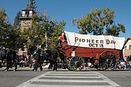
Vintage Wagon -
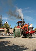
Vintage Tractor -
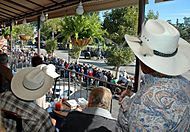
View From the Paso Robles Inn -
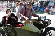
1915 Harley Davidson


In December 1940, a fire completely destroyed the "fire-proof" El Paso de Robles Hotel. Guests staying the night escaped unharmed. However, the night clerk who discovered the fire suffered a fatal heart attack immediately after sounding the alarm. Within months after the blaze, plans for a new hotel to be built on the site were drawn up. The design was an entirely new concept: A Garden Inn – Hotel, designed to accommodate motor vehicle travellers. By February 1942 construction was complete and the new Paso Robles Inn opened for business.
Through the 1960s and 1970s, the City of Paso Robles experienced significant growth. The area's wine industry flourished, the California Mid-State Fair expanded into a regional attraction, and local lakes, such as Lake Nacimiento, became family vacation destinations.
The waters
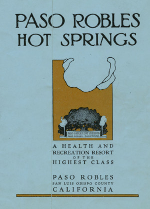
As far back as 1795, Paso Robles has been spoken of and written about as “California’s oldest watering place”—the place to go for springs and mud baths. In 1864, a correspondent to the San Francisco Bulletin wrote that there was every prospect of the Paso Robles hot springs becoming the watering place of the state. By 1868 people were coming from as far away as Oregon, Nevada, Idaho, and even Alabama. Besides the well-known mud baths, there were the Iron Spring and the Sand Spring, which bubbles through the sand and was said to produce delightful sensations.
In 1882, Drury James and the Blackburn brothers issued a pamphlet advertising “El Paso de Robles Hot and Cold Sulphur Springs and the Only Natural Mud Baths in the World.” By then there were first class accommodations—a reading room, barber shop, and telegraph office; a general store, a top-of-the-line livery stable, and comfortably furnished cottages for families that preferred privacy to quarters in the hotel. Visitors could stay in touch with the rest of the world, as there were two daily mails, a Western Union telegraph office, and a Wells Fargo agency with special rates for guests. As the springs became more and more a destination of the well-to-do as a place to go to socialize, the original purpose of the springs—to heal—became peripheral.
The bathhouse was erected over the sulphur spring in 1888, with a plunge and thirty-seven bath rooms. In the following year, work began on the large Hot Springs Hotel, (today the Paso Robles Inn), which was completed in 1900 and burned down 40 years later. Since the privileges of using the baths were restricted to guests of the hotel and many sufferers of the ailments the baths cured could not pay the rates of the fashionable hotel, a few businessmen in Paso Robles made arrangements with Felix Liss for the right to bore for sulphur water on a lot which Liss owned. A sulphur well was reached, a bath house built and baths offered at an affordable rate of twenty-five cents. The establishment was later offered to the City and is currently the site of the Municipal Pool.
The wine
Paso Robles’ growth industry—wine—has a long history with the area. Wine grapes were introduced to the Paso Robles soil in 1797 by the Spanish conquistadors and Franciscan missionaries. Spanish explorer Francisco Cortez envisioned an abundant wine-producing operation and encouraged settlers from Mexico and other parts of California to cultivate the land. The first vineyardists in the area were the Padres of the Mission San Miguel, and their old fermentation vats and grapevine artwork can still be seen at the Mission, north of the city of Paso Robles.
Commercial winemaking was introduced to the Paso Robles region in 1882 when Andrew York, a settler from Indiana, began planting vineyards and established the Ascension Winery at what is became York Mountain Winery and is now Epoch Winery. When York purchased the land, it was primarily apple orchards, with a small plot of wine grape vines. York found that the climate and soil were more suitable for vineyards and he expanded the vineyards. Within a few years, he found that the vines were yielding more than he could market, prompting him to build a small, stone winery.
Following Andrew York’s early success in the wine business, Gerd and Ilsabe Klintworth planted a vineyard in the Geneseo/Linne area in approximately 1886. They were licensed to sell jugs of Zinfandel, Port, and Muscatel, as well as some of the area’s first white wine made from Burger grapes. The Casteel Vineyards in the Willow Creek area were planted just prior to 1908. Casteel wines were stored and aged in a cave cellar. Cuttings from the old vines provided the start for other vineyards, still producing in the area today.
As the popularity of wines began to grow, so did the Paso Robles wine region. Lorenzo and Rena Nerelli purchased their vineyard at the foot of York Mountain in 1917. Their Templeton Winery was the area’s first to be bonded following the repeal of Prohibition.
The early 1920s saw a flurry of winemaking activity when several families immigrated to the area to establish family vineyards and wineries. Sylvester and Caterina Dusi purchased a vineyard in 1924. The old head-pruned Zinfandel vines are now owned and cultivated by their son, Benito. The Martinelli, Busi, Vosti, Steinbeck and Bianchi Winery vineyards were also established around this time.
The Paso Robles wine region gained more notoriety when Ignace Paderewski, the famous Polish statesman and concert pianist, visited Paso Robles, became enchanted with the area, and purchased 2,000 acres (8.1 km2). In the early 1920s, he planted Petite Sirah and Zinfandel on his Rancho San Ignacio vineyard in the Adelaide area. Following Prohibition, Paderewski's wine was made at York Mountain Winery. The wines produced from grapes grown on Rancho San Ignacio went on to become award-winners. Paso Robles’ reputation as a premier wine region became firmly established as a result of this and later successes, and through to the late 1960s and early 1970s, a new generation of vineyard pioneers came forth and flourished in the Paso Robles area.
San Simeon earthquake
At 11:15am PST on December 22, 2003, an earthquake, known as the San Simeon earthquake, struck about 25 miles (40 km) North-West of Paso Robles. The quake registered a magnitude 6.5 on the Richter Magnitude Scale, and caused two deaths when the roof slid off the clock tower building, a popular landmark in downtown Paso Robles. The dormant underground springs that had once been used for the spa were brought back to life by the quake, causing flooding and a large sinkhole in the parking lot of the city hall and library. Due to lengthy environmental and engineering considerations, it took until December 2010 for the sinkhole to be filled and the parking lot resurfaced. Paso Robles has dedicated a new clock tower in memory of the two women who died on that day.
Demographics
| Historical population | |||
|---|---|---|---|
| Census | Pop. | %± | |
| 1890 | 827 | — | |
| 1900 | 1,224 | 48.0% | |
| 1910 | 1,441 | 17.7% | |
| 1920 | 1,919 | 33.2% | |
| 1930 | 2,573 | 34.1% | |
| 1940 | 3,045 | 18.3% | |
| 1950 | 4,835 | 58.8% | |
| 1960 | 6,677 | 38.1% | |
| 1970 | 7,168 | 7.4% | |
| 1980 | 9,163 | 27.8% | |
| 1990 | 18,583 | 102.8% | |
| 2000 | 24,297 | 30.7% | |
| 2010 | 29,793 | 22.6% | |
| 2019 (est.) | 32,153 | 7.9% | |
| U.S. Decennial Census | |||
2010 Census
The 2010 United States Census reported that Paso Robles had a population of 29,793. The population density was 1,533.7 people per square mile (592.2/km2). The racial makeup of Paso Robles was 23,158 (77.7%) White, 622 (2.1%) African American, 297 (1.0%) Native American, 593 (2.0%) Asian, 56 (0.2%) Pacific Islander, 3,916 (13.1%) from other races, and 1,151 (3.9%) from two or more races. Hispanic or Latino of any race were 10,275 persons (34.5%).
The census reported that 29,624 people (99.4% of the population) lived in households, 164 (0.6%) lived in non-institutionalized group quarters, and 5 (0%) were institutionalized.
There were 10,833 households, out of which 4,104 (37.9%) had children under the age of 18 living in them, 5,721 (52.8%) were opposite-sex married couples living together, 1,345 (12.4%) had a female householder with no husband present, 603 (5.6%) had a male householder with no wife present. There were 767 (7.1%) unmarried opposite-sex partnerships, and 66 (0.6%) same-sex married couples or partnerships. 2,486 households (22.9%) were made up of individuals, and 1,192 (11.0%) had someone living alone who was 65 years of age or older. The average household size was 2.73. There were 7,669 families (70.8% of all households); the average family size was 3.19.
The population was spread out, with 7,829 people (26.3%) under the age of 18, 2,827 people (9.5%) aged 18 to 24, 7,870 people (26.4%) aged 25 to 44, 7,271 people (24.4%) aged 45 to 64, and 3,996 people (13.4%) who were 65 years of age or older. The median age was 35.3 years. For every 100 females, there were 94.9 males. For every 100 females age 18 and over, there were 92.4 males.
There were 11,426 housing units at an average density of 588.2 per square mile (227.1/km2), of which 6,412 (59.2%) were owner-occupied, and 4,421 (40.8%) were occupied by renters. The homeowner vacancy rate was 1.9%; the rental vacancy rate was 3.8%. 16,666 people (55.9% of the population) lived in owner-occupied housing units and 12,958 people (43.5%) lived in rental housing units.
2007 ACS census update
Note The following demographics are taken and computed from the United States Census Bureau's American Community Survey (ACS) data profiles. The demographics are compiled by the Census Bureau using data and surveys collected from the ACS, Census Bureau Population Estimates Program Link, and the California State Department of Finance from years 2005–2007. Although these US Census Bureau statistics are Estimates, they have been proven to be incredibly accurate year after year with a very small margin of error. These updated figures, although not necessary, give a better, and more current, idea of statistics such as population percentages, income figures, racial and age makeup, etc.
As of the 2007 ACS Census Update, the city limits population was estimated at 27,868 people, 7,880 families within the city, and an average citizen age of 33.2 years old. The city limits population density was 1,504.2 people per square mile (29.18 km2), there were 11,218 total available housing units with 10,876 of them occupied (total households). The racial makeup of the city was 82.0% White, 2.8% Black or African American, 1.1% Native American, 2.0% Asian, 0.08% Pacific Islander, 12.1% from other races, and 3.5% from two or more races. Hispanic or Latino of any race were 32.9% of the population. There were 10,876 households, out of which 33.9% had children under the age of 18 living with them, 52.6% were married couples living together, 14.8% had a female householder with no husband present, and 27.5% were non-families. 20.7% of all households were made up of individuals, and 8.9% had someone living alone who was 65 years of age or older. The average household size was 2.56 and the average family size was 2.96. In the city, the population was spread out, with 27.7% under the age of 18, 10.7% from 18 to 24, 25.7% from 25 to 44, 23.9% from 45 to 64, and 11.7% who were 65 years of age or older. The median age was 33.2 years. The median income for a household in the city was $51,172, and the median income for a family was $57,114. Males had a median income of $42,357 versus $29,311 for females. The per capita income for the city was $23,544. About 11.4% of families and 13.5% of the population as a whole were below the poverty line, including 18.2% of those under age 18 and 12.2% of those age 65 or over.
Transportation
Highways
Paso Robles is at the major crossroads of U.S. Highway 101 and State Highway 46, about halfway between Los Angeles and the San Francisco Bay Area with direct access to the San Joaquin Valley and Interstate 5. Paso Robles is currently served by one freeway and two highways:
 U.S. Route 101 (US 101) is the most frequented and largest road-transportation arterial for the city of Paso Robles which serves as its north–south gateway. US 101 runs in a north–south direction and bisects the city (along with the Salinas River), into its western and eastern portions. Traveling northward from the city, US 101 heads to San Jose and San Francisco, and continues on along the coast up through Northern California and Oregon, and ends near Olympia in Washington state. Traveling southward from the city, US 101 heads to San Luis Obispo, Santa Barbara, and on to its southern terminus in Los Angeles.
 State Route 46 (SR 46) is the main east–west arterial for the city of Paso Robles and serves as its eastern gateway from the San Joaquin Valley. SR 46 runs in an east–west direction except for a short portion in Paso Robles where it overlaps with US 101 for 3 miles (4.8 km). Traveling westward, SR 46 leaves the city and gradually climbs up and over the Santa Lucia Coastal Range, where it then quickly descends and meets the Pacific Ocean, just south of the coastal village of Cambria at its westernmost terminus at Highway 1, better known as the Pacific Coast Highway. Traveling eastward, SR 46 leaves the city and after traveling through rolling countryside for about 25 miles (40 km), it climbs up the Temblor Range and San Andreas Fault, then 25 miles (40 km) later, crosses Interstate 5 and continues on, later terminating at State Route 99, about 20 miles (32 km) north of Bakersfield and 90 miles (140 km) south of Fresno. In the future, SR 46 may be considered for a possible westward expansion of Interstate 40, via SR 58 from Barstow to Bakersfield, from Bakersfield to I-5 via Westside Parkway, along I-5 to SR 46, then following SR 46 to Paso Robles.
 State Route 229 is mainly an intra-county route that is used for traveling between the small rural towns in the eastern part of the county. SR 229 begins in Paso Robles as Creston Road, then 3 miles (4.8 km) east, as it leaves the city heading south-eastward, becomes simply SR 229 as it heads to the small rural town of Creston about 15 miles (24 km) southeast of Paso Robles. It then continues southward for 8 miles (13 km), where it ends at State Route 58, about 5 miles (8.0 km) east of the small town of Santa Margarita.
Rail transportation


Amtrak, the national passenger rail system, serves Paso Robles, operating its Coast Starlight daily in each direction between Seattle, Washington, and Los Angeles. Amtrak's Pacific Surfliner, which operates between San Diego and Paso Robles, connects by bus transfer from San Luis Obispo Railroad Station.
Airport
Paso Robles Municipal Airport, a regional general aviation airport, is about 5 miles (8.0 km) northeast of downtown Paso Robles. Paso Robles Municipal does not offer scheduled passenger service. Scheduled passenger market is available at the nearby San Luis Obispo County Regional Airport, 25 miles (40 km) to the south in San Luis Obispo. The Paso Robles airport has daily business aviation operations, in addition to serving as a large general aviation base. The California Department of Forestry and Fire Protection (CAL FIRE) has an air attack base at the airport. There, aircraft are reloaded with fire fighting chemicals, which are dropped on brush and forest fires. The local Civil Air Patrol squadron also operates and trains on the airbase as part of the localized squadron 103, performing training craft operations known as O-Flights in a trainer craft that is brought to a desired altitude then dropped, essentially being towed by the aircraft, cadets of the Civil Air Patrol are the most of this demographic, but the cadets also help out congestion in the airport when it is busy during the operations. Also, the California Highway Patrol (CHP) houses a fixed-wing aircraft, used for speed enforcement, and a helicopter, used for search and rescue. The area immediately surrounding the Paso Robles Airport, known as Airport Road Industrial Park, is also home to many aviation maintenance providers and facilities, as well as home to many aviation parts manufacturers and other related businesses. LaGuardia's Italian Deli is the only restaurant on the field, and is located in the terminal building. The deli opened in November 2012.
The Paso Robles Airport hosts the Northern California Regional Aerobatic Contest which is held annually in mid-June.
Sports and recreation
Paso Robles offers its residents and visitors cycling, golfing, tennis and swimming. In 2009 and 2011, Paso Robles was the finish line for Stage 5 of the AMGEN Tour of California. Since 2008, Paso Robles hosts the annual Wine Vine Run, a half marathon and 5k foot race to benefit Paso Robles High School youth sports programs.
Lake Nacimiento is an 18-mile (29 km)-long lake located about 13 miles (21 km) north-west of the city up in the Santa Lucia Range. Although Lake Nacimiento is not actually located within the city of Paso Robles itself, it is however in what is considered the Greater Paso Robles Area. "The Lake", as it is known to locals, shares the 93446 zip code with Paso Robles, due to its proximity to the city. The lake provides ample room for waterskiing, wakeboarding, jetskiing, and other water-related activities, in addition to fishing and swimming.
Parks and recreation
Located just off of Highway 46 East at Union Road is the 42-acre (170,000 m2) Barney Schwartz Park. The park has baseball, softball and soccer facilities, as well as lake access, picnicking, event pavilions, picnicking and playgrounds. Centennial Park is located in the eastern section of Paso Robles. Besides being the home of all indoor community sports (basketball, volleyball and gymnastics) and many different classes and activities, the 17-acre (69,000 m2) Centennial Park contains a 200,000-gallon swimming pool and wading pool with waterslides, group barbecue areas, grassy picnic and pavilion areas, an amphitheater, walking paths, two outdoor half-court basketball courts, five pickleball courts, four tennis courts, a 1.2-mile-long (1.9 km) paved trail, four lighted tennis courts and two playgrounds.
The land upon which City Park sits was donated by the town's founders, James and Blackburn, for the specific use of a public park. Located in the heart of downtown, the 5-acre (20,000 m2) park provides easy access to the downtown area's amenities. Holiday and festival events are often held at this park, including holidays such as the 4th of July. City Park hosts “Concerts in the Park”, Trading Day, bi-weekly farmers markets, the Wine Festival, the Olive Festival, the Festival of the Arts, and several car shows.
Sherwood Park is located on the upper south-east side of town and is used mostly for youth sports. The Little League field was completely redone in April 2002. In addition to the renovated Little League Field, Sherwood Park has one basketball court, horseshoe pits, a sand volleyball court, barbecue areas, three soccer fields, a softball field, and tennis courts. The park also features a playground area with a medieval theme called Sherwood Forest.
Venues
- Paso Robles Event Center, home to the California Mid-State Fair
- Vina Robles Amphitheatre, a 3000-seat outdoor theatre, opened in 2013.
- River Oaks Hot Springs Spa, outdoor venue
- Paso Robles Inn Ballroom, indoor venue
Sustainable building
Several companies in the area specialize in straw-bale construction, insulating concrete forms, rammed earth, super insulated buildings, and Leadership in Energy and Environmental Design (L.E.E.D) construction. Within a 15-mile (24 km) radius of downtown Paso Robles there are twelve straw bale homes, six insulated concrete homes, and several straw bale wineries/tasting rooms.
Economy
Wine and vineyards

The Paso Robles Wine Country has a number of wineries and vineyards in the area. It is the location of the Paso Robles AVA (American Viticultural Area). More than 25 different varieties of grapes are grown in the Paso Robles Wine Country and there are over 250 bonded wineries.
In 1993, Paso Robles grape growers, wineries and wine tasting rooms united to form the Paso Robles Wine Country Alliance. This non-profit trade organization is dedicated to the promotion and education of the Paso Robles premium wine country.
The Paso Robles Wine Country Alliance is a cooperative marketing alliance made up of Paso Robles Wine Country wineries, vineyards and related businesses. They host many of the festivals in the Paso Robles Area, and strengthen brand awareness locally, regionally and nationally. The wine alliance focuses on trade and consumer outreach, media relations, buyer tours, educational and research programs and giving back to education and health organizations in the Paso Robles community.
Sustainable building
Several companies in the area specialize in straw-bale construction, insulating concrete forms, rammed earth, super insulated buildings, and Leadership in Energy and Environmental Design (L.E.E.D) construction. Within a 15-mile (24 km) radius of downtown Paso Robles there are twelve straw bale homes, six insulated concrete homes, and several straw bale wineries/tasting rooms.
Education
The Paso Robles Public Schools District contains six elementary schools, two middle schools, three high schools, and four other miscellaneous school sites and programs.
Elementary and middle schools

- Bauer–Speck Elementary (K–5)
- Georgia Brown Elementary (Dual language immersion campus) (K–5)
- Kermit King Elementary (K–5)
- Pat Butler Elementary (K–5)
- Virginia Peterson Elementary (K–5)
- Winifred Pifer Elementary (K–5)
- George Flamson Middle School (6–8)
- Daniel Lewis Middle School (6–8)
- Saint Rose of Lima School (Pres.–8)
- Trinity Lutheran School (Pres.–8)
High schools
- Paso Robles High School
- Liberty High School
- Independence High School
Colleges and adult education
- Cuesta College
- Paso Robles Adult School
- PR Culinary Arts Academy
- University of Phoenix Satellite Office
Notable people
- Frank Armitage, muralist, painter, former Walt Disney imagineer
- Casey Biggs, actor, best known for his work on Star Trek: Deep Space Nine; has a home in Paso Robles and has done commercials for Paso Robles wine
- Jason Botts, born in 1980 in Paso Robles, was designated hitter and outfielder for Texas Rangers
- Christine Clayburg, correspondent for Fox News Channel
- Larry Grant, former American football linebacker, played for the San Francisco 49ers in the NFL. Former head football coach at Paso Robles High School.
- Dennis Harrah, former NFL offensive lineman, played 13 seasons for the Los Angeles Rams.
- Terry Hoage, former NFL player, currently operates Terry Hoage Vineyards in Paso Robles
- Derrick Jasper, assistant coach for Texas Tech Red Raiders men's basketball team; former men's basketball player for Kentucky Wildcats and UNLV Rebels
- Rusty Kuntz, baseball player for 1984 World Series champion Detroit Tigers and coach for 2015 World Series champion Kansas City Royals, attended Paso Robles High School
- Frank Minini, NFL player, born in Paso Robles
- Colleen Moore, actress, died in Paso Robles
- Ignacy Jan Paderewski, world-famous Polish pianist; was elected prime minister and Minister of Foreign Affairs in 1919 of Poland; planted extensive orchards and vineyards in Paso Robles
- Don Parish (American football), 1948-2018
- Hampton John "Hamp" Pool (1915–2000), football player, coach and scout who was part of two National Football League championship teams during his playing career and served as head coach for three professional teams
- Hal Rhyne (1899–1971), shortstop for the Pittsburgh Pirates (1926–1927), Boston Red Sox (1929–1932) and Chicago White Sox (1933); one of only two major leaguers to have been born in Paso Robles
- Hunter Tylo, actress, lives in Paso Robles
- Mitchell Van Dyk, NFL offensive tackle
- Elena Verdugo, born April 25, 1925, in Paso Robles, starred in films and on television series Marcus Welby, M.D. and has a star on Hollywood Walk of Fame
- King Vidor (1894–1992), pioneering film director
- Jake Zemke, professional motorcycle racer
See also
 In Spanish: El Paso de Robles para niños
