
Patapsco River facts for kids
Quick facts for kids Patapsco River |
|
 Patapsco Valley State Park at Catonsville.
|
|
| Country | United States |
|---|---|
| State | Maryland |
| Tributaries | |
| - left | North Branch |
| - right | South Branch |
| Cities | Baltimore, Elkridge, Ellicott City |
| Source | |
| - location | Marriottsville |
| - elevation | 260 ft (79 m) |
| - coordinates | 39°20′59″N 76°52′56″W / 39.3498272°N 76.8821987°W |
| Mouth | Chesapeake Bay |
| - location | Baltimore |
| - elevation | 0 ft (0 m) |
| - coordinates | 39°10′25″N 76°26′36″W / 39.1737202°N 76.4432935°W |
| Basin | 632 sq mi (1,637 km²) |
The Patapsco River is a river in the state of Maryland in the United States. It is 39 miles (63 km) long. The name "Patapsco" comes from the language of the Algonquian tribe of Native Americans. The Alginquian word pota-psk-ut means "backwater" or "tide covered with froth."
The river runs through central Maryland and empties into the Chesapeake Bay. The mouth of the river, where it enters the Chesapeake Bay, serves as the city of Baltimore's Inner Harbor. The river has two tributaries. The North Branch runs north. The South Branch runs east and is the northern border of Howard County, Maryland.
Related pages
Images for kids
-
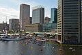
The Inner Harbor viewed from the Baltimore Aquarium
-
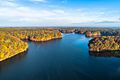
Liberty Reservoir
-
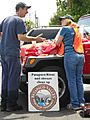
Volunteers at a community cleanup of Herbert Run, a tributary of the Patapsco River running through Arbutus, Maryland


See also
 In Spanish: Río Patapsco para niños
