
Paulsboro, New Jersey facts for kids
Quick facts for kids
Paulsboro, New Jersey
|
|
|---|---|
|
Borough
|
|
| Borough of Paulsboro | |

The Paul House
|
|

Map of Paulsboro highlighted within Gloucester County. Inset: Location of Gloucester County in New Jersey.
|
|

Census Bureau map of Paulsboro, New Jersey
|
|
| Country | |
| State | |
| County | |
| Incorporated | March 2, 1904 |
| Named for | Samuel Phillip Paul |
| Government | |
| • Type | Borough |
| • Body | Borough Council |
| Area | |
| • Total | 2.63 sq mi (6.81 km2) |
| • Land | 1.92 sq mi (4.98 km2) |
| • Water | 0.71 sq mi (1.83 km2) 26.81% |
| Area rank | 367th of 565 in state 16th of 24 in county |
| Elevation | 20 ft (6 m) |
| Population | |
| • Total | 6,097 |
| • Estimate
(2019)
|
5,854 |
| • Rank | 342nd of 566 in state 14th of 24 in county |
| • Density | 3,216.4/sq mi (1,241.9/km2) |
| • Density rank | 205th of 566 in state 5th of 24 in county |
| Time zone | UTC−05:00 (Eastern (EST)) |
| • Summer (DST) | UTC−04:00 (Eastern (EDT)) |
| ZIP Code |
08066
|
| Area code(s) | 856 exchanges: 224, 423, 467, 599 |
| FIPS code | 3401557150 |
| GNIS feature ID | 0885344 |
Paulsboro is a borough in Gloucester County, New Jersey, United States. As of the 2010 United States Census, the borough's population was 6,097, reflecting a decline of 63 (-1.0%) from the 6,160 counted in the 2000 Census, which had in turn declined by 417 (-6.3%) from the 6,577 counted in the 1990 Census.
Paulsboro was formed as a borough by an act of the New Jersey Legislature on March 2, 1904, from portions of Greenwich Township. It was named for Samuel Phillip Paul, son of a settler.
Contents
History
Paulsboro is the home of Fort Billingsport, the first land purchase made by the United States, acquired the day after the signing of the United States Declaration of Independence.
Paulsboro is the location of the Tinicum Island Rear Range Lighthouse, first lit on the night of December 31, 1880. In 1997 a local citizen's group was established with the purpose of providing tours and public access to the structure. The lighthouse is one of New Jersey's few publicly accessible aids to navigation and is the centerpiece of Paulsboro's cultural revitalization.
The East Jefferson Street railroad bridge over Mantua Creek was built in 1917 and rebuilt in 1940 for the Pennsylvania-Reading Seashore Lines (PRSL). It is now part of Conrail's Penns Grove Secondary. On November 30, 2012 it buckled, causing seven cars of a freight train to derail. One of the four tanker cars that fell into the creek was punctured, leaking thousands of gallons of vinyl chloride. Homes in the borough had to be evacuated and dozens of people went to hospitals as a precautionary measure due to exposure to the chemicals. Some residents in the area have filed suit against Conrail and CSX in Pennsylvania State Court having "complained about respiratory and bronchial related illnesses, headaches, eye and skin irritations and multiple other symptoms." In March 2013, Conrail announced that the bridge would be replaced with an expected September 2014 operational date. Normally, between March 1 and November 30 the bridge is left in the open position for maritime traffic and closed when trains approach. It will remain locked in the closed position until the bridge is replaced. In September 2013, another less serious derailment took place along the Paulsboro Gibbstown border, with one car leaving the tracks on a train consisting mostly of empty tanker cars.
Geography
According to the United States Census Bureau, the borough had a total area of 2.605 square miles (6.745 km2), including 1.896 square miles (4.910 km2) of land and 0.709 square miles (1.836 km2) of water (27.21%).
Unincorporated communities, localities and place names located partially or completely within the borough include Billingsport.
The borough borders the Gloucester County municipalities of East Greenwich Township, Greenwich Township, West Deptford Township and the Delaware River.
Demographics
| Historical population | |||
|---|---|---|---|
| Census | Pop. | %± | |
| 1880 | 750 | — | |
| 1890 | 1,131 | 50.8% | |
| 1910 | 2,121 | — | |
| 1920 | 4,352 | 105.2% | |
| 1930 | 7,121 | 63.6% | |
| 1940 | 7,011 | −1.5% | |
| 1950 | 7,842 | 11.9% | |
| 1960 | 8,121 | 3.6% | |
| 1970 | 8,084 | −0.5% | |
| 1980 | 6,944 | −14.1% | |
| 1990 | 6,577 | −5.3% | |
| 2000 | 6,160 | −6.3% | |
| 2010 | 6,097 | −1.0% | |
| 2019 (est.) | 5,854 | −4.0% | |
| Population sources: 1880-1890 1910-2000 1910-1920 1910 1910-1930 1930-1990 2000 2010 |
|||
Census 2010
As of the census of 2010, there were 6,097 people, 2,286 households, and 1,591 families residing in the borough. The population density was 3,216.4 per square mile (1,241.9/km2). There were 2,533 housing units at an average density of 1,336.2 per square mile (515.9/km2)*. The racial makeup of the borough was 54.49% (3,322) White, 36.72% (2,239) Black or African American, 0.34% (21) Native American, 0.71% (43) Asian, 0.07% (4) Pacific Islander, 2.35% (143) from other races, and 5.33% (325) from two or more races. [[Hispanic (U.S. Census)|Hispanic or Latino of any race were 8.89% (542) of the population.
There were 2,286 households out of which 33.9% had children under the age of 18 living with them, 33.7% were married couples living together, 28.1% had a female householder with no husband present, and 30.4% were non-families. 25.7% of all households were made up of individuals, and 9.5% had someone living alone who was 65 years of age or older. The average household size was 2.66 and the average family size was 3.16.
In the borough, the population was spread out with 28.3% under the age of 18, 9.6% from 18 to 24, 26.6% from 25 to 44, 24.1% from 45 to 64, and 11.4% who were 65 years of age or older. The median age was 33.7 years. For every 100 females there were 88.4 males. For every 100 females ages 18 and old there were 82.4 males.
The Census Bureau's 2006-2010 American Community Survey showed that (in 2010 inflation-adjusted dollars) median household income was $43,846 (with a margin of error of +/- $9,449) and the median family income was $61,147 (+/- $5,392). Males had a median income of $51,923 (+/- $6,640) versus $37,826 (+/- $5,863) for females. The per capita income for the borough was $21,061 (+/- $2,252). About 8.2% of families and 12.9% of the population were below the poverty line, including 13.6% of those under age 18 and 9.9% of those age 65 or over.
Census 2000
As of the 2000 United States Census there were 6,160 people, 2,353 households, and 1,614 families residing in the borough. The population density was 3,140.8 people per square mile (1,213.5/km2). There were 2,628 housing units at an average density of 1,339.9 per square mile (517.7/km2). The racial makeup of the borough was 63.56% White, 31.64% African American, 0.24% Native American, 0.32% Asian, 0.10% Pacific Islander, 1.31% from other races, and 2.82% from two or more races. Hispanic or Latino of any race were 4.35% of the population.
There were 2,353 households, out of which 33.1% had children under the age of 18 living with them, 38.0% were married couples living together, 24.7% had a female householder with no husband present, and 31.4% were non-families. 26.9% of all households were made up of individuals, and 11.6% had someone living alone who was 65 years of age or older. The average household size was 2.61 and the average family size was 3.15.
In the borough the population was spread out, with 28.8% under the age of 18, 8.3% from 18 to 24, 29.8% from 25 to 44, 19.3% from 45 to 64, and 13.9% who were 65 years of age or older. The median age was 34 years. For every 100 females, there were 88.1 males. For every 100 females age 18 and over, there were 81.7 males.
The median income for a household in the borough was $35,569, and the median income for a family was $41,359. Males had a median income of $32,313 versus $24,779 for females. The per capita income for the borough was $16,368. About 14.6% of families and 17.7% of the population were below the poverty line, including 27.0% of those under age 18 and 9.2% of those age 65 or over.
Transportation
_in_Paulsboro,_Gloucester_County,_New_Jersey.jpg)
Roads and highways
As of May 2010[update], the borough had a total of 26.02 miles (41.88 km) of roadways, of which 22.58 miles (36.34 km) were maintained by the municipality, 1.62 miles (2.61 km) by Gloucester County and 1.82 miles (2.93 km) by the New Jersey Department of Transportation.
Interstate 295 and U.S. Route 130 pass through the southern tip of Paulsboro and Route 44 also traverses the borough.
Public transportation
NJ Transit bus service is available between Pennsville Township and Philadelphia on the 402 route, with local service offered on the 455 route between Cherry Hill Mall and Woodbury.
The borough operates shuttle bus service throughout the day.
Port of Paulsboro
The Port of Paulsboro is located on the Delaware River and Mantua Creek in and around Paulsboro, and is traditionally one of the nation's busiest for marine transfer operations of petroleum products. From 1998 to early 2011, the Valero Energy Corporation operated an oil refinery here, which it sold in a 2010 deal to PBF Energy for $360 million. The port is being redeveloped as an adaptable omniport able to handle a diversity of bulk, break bulk cargo and shipping containers. Studies completed in 2012 concluded that the port is well-suited to become a center for the manufacture, assembly, and transport of wind turbines and platforms for the development of Atlantic Wind Connection The port has also been home to America's largest asphalt refinery, scheduled to close in 2017.
Education
The Paulsboro Public Schools serves students in kindergarten through twelfth grade. As of the 2017–18 school year, the district, comprised of four schools, had an enrollment of 1,205 students and 103.1 classroom teachers (on an FTE basis), for a student–teacher ratio of 11,7:1. Schools in the district (with 2017-18 enrollment data from the National Center for Education Statistics) are Billingsport Early Childhood Center (351 students; in grades K-2), Loudenslager Elementary School (291; 3–6), Paulsboro Junior High School (163; 7–8) and Paulsboro High School (317; 9–12).
Students in ninth through twelfth grades from Greenwich Township attend the district's high school as part of a sending/receiving relationship with the Greenwich Township School District. As of the 2017–18 school year, the high school had an enrollment of 317 students and 39.4 classroom teachers (on an FTE basis), for a student–teacher ratio of 8.0:1.
Students from across the county are eligible to apply to attend Gloucester County Institute of Technology, a four-year high school in Deptford Township that provides technical and vocational education. As a public school, students do not pay tuition to attend the school.
The Roman Catholic Diocese of Camden includes the Guardian Angels Regional School. Its 4-8 campus is in Paulsboro while its PreK-3 campus is in Gibbstown.
Notable people
People who were born in, residents of, or otherwise closely associated with Paulsboro include:
- Flipper Anderson (born 1965 as Willie Lee Anderson Jr.), wide receiver who played in the NFL for nine seasons for four different teams.
- John J. Burzichelli (born 1954), member of the New Jersey General Assembly who was also a long-time mayor of Paulsboro.
- Russell Carter (born 1985), a First Team All-Big East basketball player at the University of Notre Dame in 2006–2007.
- Julién Davenport (born 1995), offensive tackle for the Indianapolis Colts.
- Gerald Hodges (born 1991), linebacker who has played in the NFL for the Minnesota Vikings.
- Isaac F. Hughes (1861–1931), member of the Los Angeles City Council, 1925–1927.
- Henry C. Loudenslager (1852–1911), represented New Jersey's 1st congressional district from 1893 to 1911.
- Tony Montanaro (1927-2002), mime artist who switched to the art from stage acting after seeing Marcel Marceau's 1956 performances in New York City.
- Isaac Redman (born 1984), running back for the Pittsburgh Steelers.
- Kevin Ross (born 1962), Paulsboro High and Temple University graduate, played in the National Football League for 14 seasons for three different teams.
- Anthony Scirrotto (born 1986), football safety.
- Larry Sharpe (born 1951), former professional wrestler who operates the Monster Factory training school in Paulsboro.
- Alex Silvestro (born 1988), tight end who has played in the NFL for the New England Patriots and Baltimore Ravens.
- Edwin H. Simmons (1921–2007), highly decorated United States Marine Corps officer.
- Joan Weber (1935-1981), singer who became a one-hit wonder with her 1954 song "Let Me Go, Lover!"
- Chazz Witherspoon (born 1981), professional boxer.
Images for kids
-
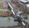
Aerial view of 2012 derailment
.jpg)
See also
 In Spanish: Paulsboro para niños
