
Pe Ell, Washington facts for kids
Quick facts for kids
Pe Ell, Washington
|
|
|---|---|

Location of Pe Ell, Washington
|
|
| Country | United States |
| State | Washington |
| County | Lewis |
| Area | |
| • Total | 0.60 sq mi (1.55 km2) |
| • Land | 0.59 sq mi (1.53 km2) |
| • Water | 0.01 sq mi (0.02 km2) |
| Elevation | 420 ft (128 m) |
| Population
(2020)
|
|
| • Total | 642 |
| • Density | 1,142.13/sq mi (440.62/km2) |
| Time zone | UTC−8 (Pacific (PST)) |
| • Summer (DST) | UTC−7 (PDT) |
| ZIP code |
98572
|
| Area code | 360 |
| FIPS code | 53-53930 |
| GNIS feature ID | 1507338 |
Pe Ell is a town in Lewis County, Washington, United States. The population was 642 at the 2020 census.
History
Pe Ell was officially incorporated on March 9, 1906.
There have long been several versions of how Pe Ell was named, none of which can be authenticated.
- The more accepted version is that the name comes from the attempts of the local Indians to pronounce the first name of an early French-Canadian settler, Pierre Charles, who was an ex-Hudson Bay employee. This version has it that the Indians could not pronounce Pierre, and their attempts turned it into Pe Ell.
- Another version is that P and L were the first initials for Pierre Charles and his Indian wife. Two words were made from the initials: "Pe Ell".
- Another distinct version is that Charlie Pershell, a Frenchman, settled in the area and married an Indian maiden. The. Indians found it difficult to sound out the "sh" in Pershell so it became Pe Ell.
In 1897, the North Pacific Railway built a railroad depot in the town. In 1907 Pe Ell's population was around 1,000—larger than it is today. The rich agricultural and timber resources of the region attracted farmers, millworkers, and loggers. By 1909, the town had a bank, three dry goods stores, two general stores, three grocery stores, two barber shops, five saloons, four hotels, a newspaper, a blacksmith, and even an opera house.
Geography
Pe Ell is located at 46°34′17″N 123°17′49″W / 46.57139°N 123.29694°W (46.571415, -123.296842).
According to the United States Census Bureau, the town has a total area of 0.59 square miles (1.53 km2), all of it land.
Demographics
| Historical population | |||
|---|---|---|---|
| Census | Pop. | %± | |
| 1910 | 838 | — | |
| 1920 | 861 | 2.7% | |
| 1930 | 891 | 3.5% | |
| 1940 | 825 | −7.4% | |
| 1950 | 787 | −4.6% | |
| 1960 | 593 | −24.7% | |
| 1970 | 582 | −1.9% | |
| 1980 | 617 | 6.0% | |
| 1990 | 547 | −11.3% | |
| 2000 | 657 | 20.1% | |
| 2010 | 632 | −3.8% | |
| 2020 | 642 | 1.6% | |
| U.S. Decennial Census 2020 Census |
|||
2010 census
As of the census of 2010, there were 632 people, 259 households, and 169 families living in the town. The population density was 1,071.2 inhabitants per square mile (413.6/km2). There were 290 housing units at an average density of 491.5 per square mile (189.8/km2). The racial makeup of the town was 91.3% White, 0.2% African American, 3.2% Native American, 1.7% from other races, and 3.6% from two or more races. Hispanic or Latino of any race were 4.3% of the population.
There were 259 households, of which 32.8% had children under the age of 18 living with them, 49.0% were married couples living together, 10.4% had a female householder with no husband present, 5.8% had a male householder with no wife present, and 34.7% were non-families. 26.6% of all households were made up of individuals, and 12.8% had someone living alone who was 65 years of age or older. The average household size was 2.44 and the average family size was 2.91.
The median age in the town was 40 years. 25% of residents were under the age of 18; 7.2% were between the ages of 18 and 24; 23.4% were from 25 to 44; 26.6% were from 45 to 64; and 17.7% were 65 years of age or older. The gender makeup of the town was 49.7% male and 50.3% female.
Images for kids
-
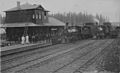
Trains at Pe Ell station along the construction route of Yakima and Pacific Coast Railroad, Washington, circa 1890-1892
.jpg)
See also
 In Spanish: Pe Ell (Washington) para niños
