Pender County, North Carolina facts for kids
Quick facts for kids
Pender County
|
|
|---|---|

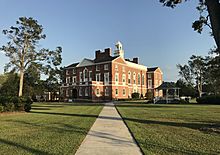
Pender County Courthouse in Burgaw, North Carolina
|
|

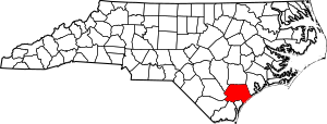
Location within the U.S. state of North Carolina
|
|
 North Carolina's location within the U.S. |
|
| Country | |
| State | |
| Founded | 1875 |
| Named for | William Dorsey Pender |
| Seat | Burgaw |
| Largest community | Hampstead |
| Area | |
| • Total | 933 sq mi (2,420 km2) |
| • Land | 870 sq mi (2,300 km2) |
| • Water | 63 sq mi (160 km2) 6.8%% |
| Population | |
| • Estimate
(2021)
|
62,815 |
| • Density | 72.2/sq mi (27.9/km2) |
| Time zone | UTC−5 (Eastern) |
| • Summer (DST) | UTC−4 (EDT) |
| Congressional district | 7th |
Pender County is a county located in the U.S. state of North Carolina. As of the 2020 census, the population was 60,203. Its county seat is Burgaw. Pender County is part of the Wilmington, NC Metropolitan Statistical Area.
Contents
History
The county was formed in 1875 from New Hanover County. It was named for William Dorsey Pender of Edgecombe County, a Confederate general mortally wounded at the Battle of Gettysburg. It is in the southeastern section of the State and is bounded by the Atlantic Ocean and New Hanover, Brunswick, Columbus, Bladen, Sampson, Duplin and Onslow counties. The present land area is 870.76 square miles (2,255.3 km2) and the 1990 population was 28,855. The county commissioners were ordered to hold their first meeting at Rocky Point. The act provided for the establishment of the town of Cowan as the county seat. In 1877 an act was passed repealing that section of the law relative to the town, and another law was enacted whereby the qualified voters were to vote on the question of moving the county seat to South Washington or any other place which the majority of the voters designated. Whatever place was selected, the town should be called Stanford. In 1879 Stanford was changed to Burgaw, which was by that law incorporated. It is the county seat.
Geography
According to the U.S. Census Bureau, the county has a total area of 933 square miles (2,420 km2), of which 870 square miles (2,300 km2) is land and 63 square miles (160 km2) (6.8%) is water. It is the fifth-largest county in North Carolina by land area.
Adjacent counties
- Duplin County, North Carolina — north
- Onslow County, North Carolina — northeast
- New Hanover County, North Carolina — south
- Brunswick County, North Carolina — south
- Columbus County, North Carolina — southwest
- Bladen County, North Carolina — west
- Sampson County, North Carolina — northwest
Protected areas
- Holly Shelter Game Land
- Lea-Hutaff Island
- Moores Creek National Battlefield
Major highways
 I-40
I-40 US 17
US 17 US 117
 US 421
 NC 11
NC 11 NC 50
NC 50 NC 53
NC 53 NC 133
 NC 210
Demographics
| Historical population | |||
|---|---|---|---|
| Census | Pop. | %± | |
| 1880 | 12,468 | — | |
| 1890 | 12,514 | 0.4% | |
| 1900 | 13,381 | 6.9% | |
| 1910 | 15,471 | 15.6% | |
| 1920 | 14,788 | −4.4% | |
| 1930 | 15,686 | 6.1% | |
| 1940 | 17,710 | 12.9% | |
| 1950 | 18,423 | 4.0% | |
| 1960 | 18,508 | 0.5% | |
| 1970 | 18,149 | −1.9% | |
| 1980 | 22,215 | 22.4% | |
| 1990 | 28,855 | 29.9% | |
| 2000 | 41,082 | 42.4% | |
| 2010 | 52,217 | 27.1% | |
| 2020 | 60,203 | 15.3% | |
| 2021 (est.) | 62,815 | 20.3% | |
| U.S. Decennial Census 1790-1960 1900-1990 1990-2000 2010-2013 |
|||
2020 census
| Race | Number | Percentage |
|---|---|---|
| White (non-Hispanic) | 44,418 | 73.78% |
| Black or African American (non-Hispanic) | 7,544 | 12.53% |
| Native American | 195 | 0.32% |
| Asian | 319 | 0.53% |
| Pacific Islander | 23 | 0.04% |
| Other/Mixed | 2,722 | 4.52% |
| Hispanic or Latino | 4,982 | 8.28% |
As of the 2020 United States census, there were 60,203 people, 21,740 households, and 14,676 families residing in the county.
Communities
Towns
Village
Census-designated places
Unincorporated communities
- Charity
- Currie
- Montague
- Register
- Sloop Point
- Willard
- Yamacraw
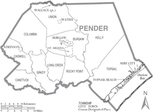
Townships
- Burgaw
- Canetuck
- Caswell
- Columbia
- Grady
- Holly
- Long Creek
- Rocky Point
- Topsail
- Union
Education
The county is served by Pender County Schools.
Notable people
- John Baptista Ashe, born in Rocky Point township, delegate to the Continental Congress
- John Baptista Ashe, born in Rocky Point township, nephew of the above, United States Congressman from North Carolina
- William Shepperd Ashe, born in Rocky Point township, United States Congressman from North Carolina
See also
 In Spanish: Condado de Pender para niños


