Penns Grove, New Jersey facts for kids
Quick facts for kids
Penns Grove, New Jersey
|
|
|---|---|
|
Borough
|
|
| Borough of Penns Grove | |

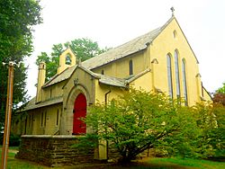
Church of Our Merciful Saviour
|
|
| Motto(s):
Pride in Progress
|
|

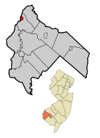
Penns Grove Borough highlighted in Salem County. Inset map: Salem County highlighted in the State of New Jersey.
|
|

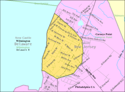
Census Bureau map of Penns Grove, New Jersey
|
|
| Country | |
| State | |
| County | |
| Incorporated | March 8, 1894 |
| Named for | William Penn |
| Government | |
| • Type | Borough |
| • Body | Borough Council |
| Area | |
| • Total | 0.89 sq mi (2.31 km2) |
| • Land | 0.89 sq mi (2.31 km2) |
| • Water | 0.00 sq mi (0.00 km2) 0.00% |
| Area rank | 517th of 565 in state 15th of 15 in county |
| Elevation | 7 ft (2 m) |
| Population | |
| • Total | 5,147 |
| • Estimate
(2019)
|
4,757 |
| • Rank | 373rd of 566 in state 4th of 15 in county |
| • Density | 5,656.0/sq mi (2,183.8/km2) |
| • Density rank | 92nd of 566 in state 1st of 15 in county |
| Time zone | UTC−05:00 (Eastern (EST)) |
| • Summer (DST) | UTC−04:00 (Eastern (EDT)) |
| ZIP Code |
08069
|
| Area code(s) | 856 exchanges: 299, 351 |
| FIPS code | 3403357750 |
| GNIS feature ID | 0885348 |
| Website | |
Penns Grove is a borough in Salem County, New Jersey, United States. As of the 2010 United States Census, the borough's population was 5,147, reflecting an increase of 261 (+5.3%) from the 4,886 counted in the 2000 Census, which had in turn declined by 342 (-6.5%) from the 5,228 counted in the 1990 Census.
Penns Grove had the fourth-highest property tax rate in New Jersey, with an equalized rate of 5.556% in 2020, compared to 3.476% in Salem County and a statewide average of 2.279%.
Contents
History
This area was long primarily agricultural. Penns Grove was incorporated as a borough by an act of the New Jersey Legislature on March 8, 1894, from portions of Upper Penns Neck Township (now Carneys Point Township), based on the results of a referendum held two days earlier. It began to industrialize around this time. The borough's name comes from William Penn.
In the early 20th century, many Italian immigrants from Valle San Giovanni and the surrounding southern province of Teramo came to work at the local E.I. DuPont de Nemours plant in Carneys Point. Many settled on Pitman Street in Penns Grove. In 1925, the Italian community arranged to commission a copy of the statue of the Madonna and Child from the Chiesa della Madonna delle Grazie in Teramo, and had it installed in the Saint James Roman Catholic Church in Penns Grove. Other immigrants from eastern Europe also settled in the county, markedly increasing the population.
Also in the 20th century, this area became a destination for Black Americans in the Great Migration who came north for industrial jobs. Some Black Americans in the area were descended from slave families from the colonial and early federal period. Since the late 20th century, new immigrants have arrived from Central and South America, and are among the rising Latino minority.
Geography
According to the United States Census Bureau, the borough had a total area of 0.912 square miles (2.361 km2), including 0.910 square miles (2.357 km2) of land and 0.002 square miles (0.004 km2) of water (0.18%).
The borough borders Carneys Point Township and the Delaware River. The borough is located across the Delaware River from Wilmington, which is part of the Delaware Valley, and 33 miles (53 km) south of Philadelphia.
Demographics
| Historical population | |||
|---|---|---|---|
| Census | Pop. | %± | |
| 1900 | 1,826 | — | |
| 1910 | 2,118 | 16.0% | |
| 1920 | 6,060 | 186.1% | |
| 1930 | 5,895 | −2.7% | |
| 1940 | 6,488 | 10.1% | |
| 1950 | 6,669 | 2.8% | |
| 1960 | 6,176 | −7.4% | |
| 1970 | 5,727 | −7.3% | |
| 1980 | 5,760 | 0.6% | |
| 1990 | 5,228 | −9.2% | |
| 2000 | 4,886 | −6.5% | |
| 2010 | 5,147 | 5.3% | |
| 2019 (est.) | 4,757 | −7.6% | |
| Population sources: 1900-2000 1900-1920 1900-1910 1910-1930 1930-1990 2000 2010 |
|||
Census 2010
As of the census of 2010, there were 5,147 people, 1,801 households, and 1,235 families residing in the borough. The population density was 5,656.0 per square mile (2,183.8/km2). There were 2,004 housing units at an average density of 2,202.2 per square mile (850.3/km2)*. The racial makeup of the borough was 41.83% (2,153) White, 39.77% (2,047) Black or African American, 0.66% (34) Native American, 0.49% (25) Asian, 0.00% (0) Pacific Islander, 12.40% (638) from other races, and 4.86% (250) from two or more races. [[Hispanic (U.S. Census)|Hispanic or Latino of any race were 28.27% (1,455) of the population.
There were 1,801 households out of which 36.8% had children under the age of 18 living with them, 29.9% were married couples living together, 31.6% had a female householder with no husband present, and 31.4% were non-families. 25.3% of all households were made up of individuals, and 9.4% had someone living alone who was 65 years of age or older. The average household size was 2.85 and the average family size was 3.38.
In the borough, the population was spread out with 32.3% under the age of 18, 10.1% from 18 to 24, 26.9% from 25 to 44, 21.2% from 45 to 64, and 9.5% who were 65 years of age or older. The median age was 29.7 years. For every 100 females there were 89.5 males. For every 100 females ages 18 and old there were 82.5 males.
The Census Bureau's 2006-2010 American Community Survey showed that (in 2010 inflation-adjusted dollars) median household income was $30,104 (with a margin of error of +/- $9,093) and the median family income was $37,663 (+/- $9,442). Males had a median income of $42,908 (+/- $8,706) versus $30,353 (+/- $5,538) for females. The per capita income for the borough was $15,785 (+/- $2,169). About 28.1% of families and 28.2% of the population were below the poverty line, including 41.2% of those under age 18 and 15.8% of those age 65 or over.
Census 2000
As of the 2000 United States Census there were 4,886 people, 1,827 households, and 1,231 families residing in the borough. The population density was 5,275.8 people per square mile (2,028.5/km2). There were 2,075 housing units at an average density of 2,240.5 per square mile (861.5/km2). The racial makeup of the borough was 48.85% White, 39.75% African American, 0.37% Native American, 0.29% Asian, 0.16% Pacific Islander, 8.13% from other races, and 2.46% from two or more races. Hispanic or Latino of any race were 17.29% of the population.
There were 1,827 households, out of which 38.4% had children under the age of 18 living with them, 34.6% were married couples living together, 27.5% had a female householder with no husband present, and 32.6% were non-families. 28.1% of all households were made up of individuals, and 13.0% had someone living alone who was 65 years of age or older. The average household size was 2.67 and the average family size was 3.26.
In the borough the population was spread out, with 33.0% under the age of 18, 8.9% from 18 to 24, 27.9% from 25 to 44, 18.5% from 45 to 64, and 11.8% who were 65 years of age or older. The median age was 31 years. For every 100 females, there were 85.5 males. For every 100 females age 18 and over, there were 79.6 males.
The median income for a household in the borough was $26,227, and the median income for a family was $34,076. Males had a median income of $30,871 versus $20,983 for females. The per capita income for the borough was $13,330. About 18.1% of families and 21.0% of the population were below the poverty line, including 29.1% of those under age 18 and 13.3% of those age 65 or over.
Transportation
Roads and highways
As of May 2010[update], the borough had a total of 19.19 miles (30.88 km) of roadways, of which 13.76 miles (22.14 km) were maintained by the municipality, 4.14 miles (6.66 km) by Salem County and 1.29 miles (2.08 km) by the New Jersey Department of Transportation.
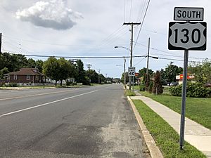
U.S. Route 130 (locally called Virginia Avenue) and Route 48 (starting at its western terminus and called Main Street within Penns Grove) both pass through the borough.
Public transportation
NJ Transit provides bus service between the borough and Philadelphia on the 402 route and to Woodstown on the 468 route.
Education
Students in public school for kindergarten through twelfth grade attend the Penns Grove-Carneys Point Regional School District, together with students from Carneys Point Township. As of the 2018–19 school year, the district, comprised of five schools, had an enrollment of 2,185 students and 182.0 classroom teachers (on an FTE basis), for a student–teacher ratio of 12.0:1. Schools in the district (with 2018–19 enrollment data from the National Center for Education Statistics) are Lafayette-Pershing School with 331 students in grades Pre-K to Kindergarten, Field Street School with 480 students in grades 1 - 3, Paul W. Carleton School with 355 students in grades 4 - 5, Penns Grove Middle School with 465 students in grades 6 - 8 and Penns Grove High School with 508 students in grades 9 - 12.
A majority of students in ninth through twelfth grades from Oldmans Township, New Jersey attend the district's high school as part of a sending/receiving relationship with the Oldmans Township School District, with the balance attending Woodstown High School in the Woodstown-Pilesgrove Regional School District.
The Catholic K-8 school St. James Elementary School of the Roman Catholic Diocese of Camden closed in 2000, with students redirected to Bishop Guilfoyle Regional Catholic School in Carneys Point, which in turn closed in 2010. As of 2020[update] Guardian Angels Regional School (Pre-K-Grade 3 campus in Gibbstown CDP and 4-8 campus in Paulsboro) takes students from Carneys Point.
Notable people
People who were born in, residents of, or otherwise closely associated with Penns Grove include:
- Don Bragg (1935-2019), Gold medal winner in the pole vault at the 1960 Summer Olympics held in Rome, Italy.
- Roy Elsh (1892–1978), professional baseball player.
- John Forsythe (1918–2010), television and character actor.
- Paul Foster (born 1931), playwright.
- Ernest Martin Hennings (1888-1956), landscape and portrait painter who was a member of the Taos Society of Artists.
- Dave Romansky (born 1938), competitive racewalker who represented the United States at the 1968 Summer Olympics.
- Bruce Willis (born 1955), actor, moved to Penns Grove as child and graduated from Penns Grove High School.
See also
 In Spanish: Penns Grove para niños


