Pennsville Township, New Jersey facts for kids
Quick facts for kids
Pennsville Township, New Jersey
|
|
|---|---|
|
Township
|
|
| Township of Pennsville | |

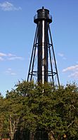
Finn's Point Rear Range Light
|
|

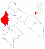
Pennsville Township highlighted in Salem County. Inset map: Salem County highlighted in the State of New Jersey.
|
|

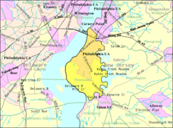
map of Pennsville Township, New Jersey
|
|
| Country | |
| State | |
| County | |
| Formed | July 10, 1721 as Lower Penns Neck Township |
| Incorporated | February 21, 1798 |
| Renamed | November 2, 1965 as Pennsville Township |
| Named for | William Penn |
| Government | |
| • Type | Township |
| • Body | Township Committee |
| Area | |
| • Total | 24.58 sq mi (63.66 km2) |
| • Land | 21.27 sq mi (55.08 km2) |
| • Water | 3.31 sq mi (8.58 km2) 13.48% |
| Area rank | 111th of 565 in state 7th of 15 in county |
| Elevation | 16 ft (5 m) |
| Population | |
| • Total | 13,409 |
| • Estimate
(2019)
|
12,418 |
| • Rank | 186th of 566 in state 1st of 15 in county |
| • Density | 630.2/sq mi (243.3/km2) |
| • Density rank | 422nd of 566 in state 5th of 15 in county |
| Time zone | UTC−05:00 (Eastern (EST)) |
| • Summer (DST) | UTC−04:00 (Eastern (EDT)) |
| ZIP Code |
08070
|
| Area code(s) | 856 |
| FIPS code | 3403357870 |
| GNIS feature ID | 0882134 |
Pennsville Township is a township in Salem County, in the U.S. state of New Jersey. As of the 2010 United States Census, the township's population was 13,409, reflecting an increase of 215 (+1.6%) from the 13,194 counted in the 2000 Census, which had in turn declined by 600 (-4.3%) from the 13,794 counted in the 1990 Census. The township is named for William Penn. The township includes the state's westernmost point.
The township had the 24th-highest property tax rate in New Jersey, with an equalized rate of 4.285% in 2020, compared to 3.476% in the county as a whole and a statewide average of 2.279%.
Contents
Geography
According to the United States Census Bureau, the township had a total area of 24.588 square miles (63.683 km2), including 21.277 square miles (55.108 km2) of land and 3.311 square miles (8.575 km2) of water (13.47%).
Pennsville CDP (with a 2010 Census population of 11,888) is a unincorporated community and census-designated place (CDP) area located within Pennsville Township.
Other unincorporated communities, localities and place names located partially or completely within the township include Cedar Point, Church Landing, Churchtown, Cobbs Island, Deepwater, Deepwater Point, Finns Point, Fort Mott, Goose Island Flats, Harrisonville, Kellys Point, Marsh Point, Penn Brick Beach, Salem Cove and Travis Cove.
The Salem River flows along the township's eastern and southern boundaries.
The township borders the Salem County municipalities of Carneys Point Township, Elsinboro Township, Mannington Township and Salem. Pennsville Township also borders a section of New Castle County, Delaware, which is one of only two points of land east of the Delaware River that are within the state of Delaware, the other being on Artificial Island in Lower Alloways Creek Township.
Demographics
| Historical population | |||
|---|---|---|---|
| Census | Pop. | %± | |
| 1810 | 1,163 | — | |
| 1820 | 1,158 | −0.4% | |
| 1830 | 993 | −14.2% | |
| 1840 | 1,219 | 22.8% | |
| 1850 | 1,429 | 17.2% | |
| 1860 | 1,506 | 5.4% | |
| 1870 | 1,472 | −2.3% | |
| 1880 | 1,334 | −9.4% | |
| 1890 | 1,280 | −4.0% | |
| 1900 | 1,424 | 11.3% | |
| 1910 | 1,544 | 8.4% | |
| 1920 | 2,149 | 39.2% | |
| 1930 | 2,933 | 36.5% | |
| 1940 | 5,113 | 74.3% | |
| 1950 | 7,376 | 44.3% | |
| 1960 | 10,417 | 41.2% | |
| 1970 | 13,296 | 27.6% | |
| 1980 | 13,848 | 4.2% | |
| 1990 | 13,794 | −0.4% | |
| 2000 | 13,194 | −4.3% | |
| 2010 | 13,409 | 1.6% | |
| 2019 (est.) | 12,418 | −7.4% | |
| Population sources: 1810-2000 1810-1920 1840 1850-1870 1850 1870 1880-1890 1890-1910 1910-1930 1930-1990 2000 2010 |
|||
Census 2010
As of the census of 2010, there were 13,409 people, 5,491 households, and 3,706 families residing in the township. The population density was 630.2 per square mile (243.3/km2). There were 5,914 housing units at an average density of 278.0 per square mile (107.3/km2)*. The racial makeup of the township was 94.68% (12,696) White, 1.54% (206) Black or African American, 0.23% (31) Native American, 1.42% (190) Asian, 0.01% (2) Pacific Islander, 0.92% (124) from other races, and 1.19% (160) from two or more races. [[Hispanic (U.S. Census)|Hispanic or Latino of any race were 3.07% (411) of the population.
There were 5,491 households out of which 27.4% had children under the age of 18 living with them, 50.6% were married couples living together, 11.9% had a female householder with no husband present, and 32.5% were non-families. 27.3% of all households were made up of individuals, and 11.6% had someone living alone who was 65 years of age or older. The average household size was 2.44 and the average family size was 2.97.
In the township, the population was spread out with 21.9% under the age of 18, 7.9% from 18 to 24, 25.0% from 25 to 44, 29.6% from 45 to 64, and 15.6% who were 65 years of age or older. The median age was 41.8 years. For every 100 females there were 95.1 males. For every 100 females ages 18 and old there were 92.1 males.
The Census Bureau's 2006-2010 American Community Survey showed that (in 2010 inflation-adjusted dollars) median household income was $58,153 (with a margin of error of +/- $4,425) and the median family income was $71,327 (+/- $6,934). Males had a median income of $53,166 (+/- $4,370) versus $42,054 (+/- $3,006) for females. The per capita income for the borough was $29,275 (+/- $1,740). About 7.0% of families and 9.8% of the population were below the poverty line, including 13.4% of those under age 18 and 5.9% of those age 65 or over.
Census 2000
As of the 2000 United States Census there were 13,194 people, 5,317 households, and 3,711 families residing in the township. The population density was 571.1 people per square mile (220.5/km2). There were 5,623 housing units at an average density of 243.4 per square mile (94.0/km2). The racial makeup of the township was 96.68% White, 0.96% African American, 0.16% Native American, 0.96% Asian, 0.02% Pacific Islander, 0.39% from other races, and 0.83% from two or more races. Hispanic or Latino of any race were 1.60% of the population.
There were 5,317 households, out of which 29.7% had children under the age of 18 living with them, 55.3% were married couples living together, 10.2% had a female householder with no husband present, and 30.2% were non-families. 26.0% of all households were made up of individuals, and 11.6% had someone living alone who was 65 years of age or older. The average household size was 2.47 and the average family size was 2.98.
In the township the population was spread out, with 23.2% under the age of 18, 7.7% from 18 to 24, 28.2% from 25 to 44, 25.4% from 45 to 64, and 15.5% who were 65 years of age or older. The median age was 39 years. For every 100 females, there were 92.4 males. For every 100 females age 18 and over there were 90.1 males.
The median income for a household in the township was $47,250, and the median income for a family was $57,340. Males had a median income of $45,523 versus $29,629 for females. The per capita income for the township was $22,717. About 3.1% of families and 4.9% of the population were below the poverty line, including 5.2% of those under age 18 and 5.1% of those age 65 or over.
Transportation
Roads and highways
As of May 2010[update], the township had a total of 90.71 miles (145.98 km) of roadways, of which 73.02 miles (117.51 km) were maintained by the municipality, 7.33 miles (11.80 km) by Salem County, 8.99 miles (14.47 km) by the New Jersey Department of Transportation, 0.95 miles (1.53 km) by the Delaware River and Bay Authority and 0.42 miles (0.68 km) by the New Jersey Turnpike Authority.
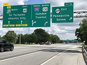
Pennsville houses county, state, U.S., Interstates and toll expressways which all converge at the northern part of the township near the hamlet of Deepwater. The southern terminus of U.S. Route 130 is in the township. Route 49 begins at the converging point and travels south for about 8.2 miles (13.2 km) through the center of town. Interstate 295 and U.S. Route 40 (multiplexed together) also pass through the north which houses Exit 1 along I-295 and which is also the Delaware Memorial Bridge that connects to the state of Delaware. In addition, the New Jersey Turnpike begins where Routes 49, 40, 130 and 295 all intersect with one another, with the creation of a roadway from Pennsville to Woodbridge Township being the initial goal when the New Jersey Turnpike Authority was created in 1948. Despite the Turnpike's southern end being in the township, Exit 1 is officially located in neighboring Carneys Point Township. The only major county road that travels through is County Road 551.
Public transportation
NJ Transit offers bus service to and from Philadelphia on the 402 route, and local service on the 468 routes.
Education
Students in public school for pre-kindergarten through twelfth grade attend the Pennsville School District. As of the 2020–21 school year, the district, comprised of five schools, had an enrollment of 1,822 students and 165.9 classroom teachers (on an FTE basis), for a student–teacher ratio of 11.0:1. Schools in the district (with 2020–21 enrollment data from the National Center for Education Statistics) are Valley Park Elementary School with 338 students in grades preK-1, Central Park Elementary School with 271 students in grades 2-3, Penn Beach Elementary School with 305 students in grades 4-5, Pennsville Middle School with 439 students in grades 6-8 and Pennsville Memorial High School with 438 students in grades 9-12.
Guardian Angels Regional School (Pre-K-Grade 3 campus in Gibbstown and 4-8 campus in Paulsboro) takes students from Pennsville. It is within the Roman Catholic Diocese of Camden.
Notable people
People who were born in, residents of, or otherwise closely associated with Pennsville Township include:
- Gene Foster (born 1942), professional football linebacker who played for the San Diego Chargers from 1965 to 1970.
- Daniel Garrison (1782-1851), member of the United States House of Representatives from New Jersey from 1823 to 1827.
- Van Homan (born 1980) profession BMX rider.
- Thomas A. Pankok (born 1931), politician who served in the New Jersey General Assembly from 1982 to 1986, where he represented the 3rd Legislative District.
- Dave Romansky (born 1938), Olympic race walker.
- Ritch Shydner (born 1951), writer, producer and actor.
- Chris Widger (born 1971), Major League Baseball catcher and World Series Champion.
- Mike Widger (1948-2016), linebacker who played in the Canadian Football League for the Montreal Alouettes and Ottawa Rough Riders.
- Norm Willey (1927–2011), defensive lineman who played in the National Football League for the Philadelphia Eagles and then taught and coached football at Pennsville Memorial High School after retiring.
See also
 In Spanish: Municipio de Pennsville (Nueva Jersey) para niños


