
Perranzabuloe facts for kids
Quick facts for kids Perranzabuloe
|
|
|---|---|
 Perranzabuloe parish church |
|
| Lua error in Module:Location_map at line 530: Unable to find the specified location map definition: "Module:Location map/data/Cornwall (mainland)" does not exist. | |
| Population | 5,406 (Civil Parish, 2011 including Barkla Shop , Callestick and Goonhavern) |
| OS grid reference | SW 770,520 |
| Unitary authority | |
| Ceremonial county | |
| Region | |
| Country | England |
| Sovereign state | United Kingdom |
| Post town | TRURO |
| Postcode district | TR4 |
| Dialling code | 01872 |
| Police | Devon and Cornwall |
| Fire | Cornwall |
| Ambulance | South Western |
| EU Parliament | South West England |
| UK Parliament |
|

Perranzabuloe is a coastal civil parish and a hamlet in Cornwall, United Kingdom. The hamlet (containing the parish church) is just over a mile (2 km) south of the main settlement of the parish, Perranporth and seven miles (11 km) south-southwest of Newquay. The parish population was 5,382 in the 2001 census.
The name of the parish comes from the medieval Latin Perranus in Sabulo meaning Piran in the sand. Piran (the patron saint of Cornwall) was a Christian evangelist who founded a church in the seventh century near the coast north of Perranporth. The ruins of this church were rediscovered in the 20th century. The medieval parish church of Perranzabuloe was over a long period completely lost in sand dunes. A new church had to be built further away from the coast.
Images for kids
-
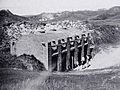
The Oratory in 1952 under a protective shell that was built before the sand was allowed to rebury it
-
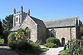
The parish church of St Piran
-
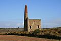
Batters' Shaft, West Chiverton mine
-
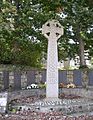
Perranzabuloe war memorial


