
Pettistree facts for kids
Quick facts for kids Pettistree |
|
|---|---|
 Village Sign |
|

Pettistree
|
|
| Population | 194 (2001) |
| OS grid reference | TM 30510 53679 |
| District | |
| Shire county | |
| Region | |
| Country | England |
| Sovereign state | United Kingdom |
| Post town | Woodbridge |
| Postcode district | IP13 |
| Dialling code | 01728 |
| Police | Suffolk |
| Fire | Suffolk |
| Ambulance | East of England |
| EU Parliament | East of England |
Pettistree is a small village and a civil parish in the Suffolk Coastal District, in the English county of Suffolk. According to the 2011 Census, Pettistree had a population of 194 people and is set in around 1,800 acres of farmland. The village has many footpaths and country lanes surrounding it. Being only one mile from the larger village of Wickham Market, Pettistree uses many of their resources; such as the Post Office, Medical and Resource Centre and Children's Play Area. The Primary School situated in Wickham Market also serves the younger children of Pettistree. However, senior children are required to travel 7 miles to Thomas Mile High School which is situated in Framlingham.
Pettistree House is a Georgian country manor house set in 13 acres of parkland. The civil parish of Pettistree comprises the manor of Pettistree, the manor of Byng, and the manor of Loudham. Byng Hall is a castellated 16th century manor house. Loudham Hall is a fine Georgian country manor house set in 69 acres. The village church of St Peter and St Pauls was originally built in the Thirteenth Century. Pettistree is just south of the small town of Wickham Market. For transport there is the A12 road nearby.
Images for kids
-
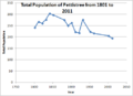
Population graph of Pettistree as reported by Census Data
-
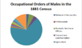
Occupation of Males in Pettistree as reported in the 1881 Census


