
Phoenicia, New York facts for kids
Quick facts for kids
Phoenicia
|
|
|---|---|

View east from NY 214 along Main Street
|
|
| Etymology: From Phoenix tannery | |

Location in Ulster County and the state of New York.
|
|
| Country | United States |
| State | New York |
| Region | Catskills |
| County | Ulster |
| Area | |
| • Total | 0.5 sq mi (1 km2) |
| Elevation | 827 ft (252 m) |
| Population
(2010)
|
|
| • Total | 309 |
| • Density | 620/sq mi (239/km2) |
| Time zone | UTC-5 (Eastern (EST)) |
| • Summer (DST) | UTC-4 (EDT) |
| ZIP Code |
12464
|
| Area code(s) | 845 |
| Exchange | 688 |
| FIPS code | 36-57650 |
| GNIS feature ID | 0960320 |
Phoenicia is a hamlet (and census-designated place) of Shandaken in Ulster County, New York, United States. The population was 309 at the 2010 census, making it the highest populated community in the town. The village center is located just off Route 28 at its junction with Route 214 and is nestled at the base of three peaks, Mount Tremper, Romer Mountain, and Sheridan Mountain. The community sits at the confluence of the Esopus Creek and Stony Clove Creek. A popular getaway for New Yorkers, the hamlet has frequented many tourism guides as among the best vacation towns in the greater New York City area.
Contents
History
The railroad (the Ulster and Delaware Railroad) arrived at this community first, making it the first to develop the tourist industry which is still a major part of the local economy. Phoenicia is also the western terminus of the Catskill Mountain Railroad's tourist operations (which run on the former Ulster and Delaware tracks). Severe washouts west of Bridge Street prevent westward operations.
Since 2010 the town has been home to the Phoenicia International Festival of the Voice every August.
The Phoenicia Railroad Station was listed on the National Register of Historic Places in 1995.
Geography
Phoenicia is located at 42°4′53″N 74°18′47″W / 42.08139°N 74.31306°W (42.081266, -74.313019).

According to the United States Census Bureau, the CDP has a total area of 0.5 square miles (1.3 km2), all land.
The community is located inside the Catskill Park.
Phoenicia is mostly covered by mountains.
Demographics
As of the census of 2000, there were 381 people, 194 households, and 82 families residing in the CDP. The population density was 823.2 per square mile (319.8/km2). There were 246 housing units at an average density of 531.5/sq mi (206.5/km2). The racial makeup of the CDP was 96.06% White, 0.26% African American, 0.52% Native American, 0.26% Asian, 0.26% Pacific Islander, and 2.62% from two or more races. Hispanic or Latino of any race were 2.62% of the population.
There were 194 households, out of which 20.1% had children under the age of 18 living with them, 26.8% were married couples living together, 10.3% had a female householder with no husband present, and 57.7% were non-families. 45.4% of all households were made up of individuals, and 23.7% had someone living alone who was 65 years of age or older. The average household size was 1.96 and the average family size was 2.88.
In the CDP, the population was spread out, with 18.1% under the age of 18, 5.8% from 18 to 24, 24.4% from 25 to 44, 28.6% from 45 to 64, and 23.1% who were 65 years of age or older. The median age was 46 years. For every 100 females, there were 87.7 males. For every 100 females age 18 and over, there were 85.7 males.
The median income for a household in the CDP was $22,159, and the median income for a family was $28,000. Males had a median income of $29,250 versus $21,750 for females. The per capita income for the CDP was $15,408. About 5.7% of families and 13.9% of the population were below the poverty line, including none of those under age 18 and 20.5% of those age 65 or over.
The Zip Code for Phoenicia is 12464, and the Area code is 845.
Images for kids
-
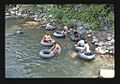
Tubing on the Esopus Creek in Phoenicia (1978)

See also
 In Spanish: Phoenicia para niños
