Pickens County, Alabama facts for kids
Quick facts for kids
Pickens County
|
|
|---|---|

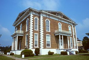
Pickens County Courthouse in Carrollton
|
|

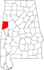
Location within the U.S. state of Alabama
|
|
 Alabama's location within the U.S. |
|
| Country | |
| State | |
| Founded | December 20, 1820 |
| Named for | Andrew Pickens |
| Seat | Carrollton |
| Largest city | Aliceville |
| Area | |
| • Total | 890 sq mi (2,300 km2) |
| • Land | 881 sq mi (2,280 km2) |
| • Water | 8.7 sq mi (23 km2) 1.0% |
| Population
(2020)
|
|
| • Total | 19,123 |
| • Estimate
(2021)
|
18,801 |
| • Density | 21.49/sq mi (8.30/km2) |
| Time zone | UTC−6 (Central) |
| • Summer (DST) | UTC−5 (CDT) |
| Congressional district | 7th |
|
|
Pickens County is a county located on the west central border of the U.S. state of Alabama. As of the 2020 census, the population was 19,123. Its county seat is Carrollton, located in the center of the county. It is a prohibition, or dry county, although the communities of Carrollton and Aliceville voted to become wet in 2011 and 2012, respectively.
Pickens County is included in the Tuscaloosa, AL Metropolitan Statistical Area
Contents
History
Pickens County was established on December 20, 1820, and named for revolutionary war hero General Andrew Pickens of South Carolina. The county seat was relocated from Pickensville to Carrollton in 1830. The first courthouse in Carrollton was burned on April 5, 1865, by troops of Union General John T. Croxton.
It was developed for cotton plantations, worked by a large population of African-American slaves brought south in the slave trade.
A second courthouse was destroyed by fire on November 16, 1876, during the last months of the Reconstruction era.
20th century to present
On April 8, 1998, a supercell thunderstorm produced an F3 tornado in Pickens County. This windstorm injured two people and damaged five homes including mobile homes. It rotated seventeen miles (27 km) from Holman to north of Northport. Twenty-four homes and thirteen mobile homes were also in the path of destruction. Moments later, that same supercell thunderstorm produced an F5 tornado that struck northeastern Tuscaloosa near the Black Warrior River before entering western Jefferson County where it destroyed Oak Grove High School and killed thirty-two people in its path.
From 2000 to 2013 the rural county had been losing population. From July 2013 to July 2014 the population grew by 5.1%, making it the fourth-fastest growing county with at least 10,000 inhabitants. In 2014 it became the fastest growing county in Alabama. This was due to the installation of the Federal Correctional Institution, Aliceville federal women's prison.
Geography
According to the U.S. Census Bureau, the county has a total area of 890 square miles (2,300 km2), of which 881 square miles (2,280 km2) is land and 8.7 square miles (23 km2) (1.0%) is water.
The county is between Tuscaloosa County and the Alabama-Mississippi state line.
Adjacent counties
- Lamar County (north)
- Fayette County (northeast)
- Tuscaloosa County (east)
- Greene County (southeast)
- Sumter County (south)
- Noxubee County, Mississippi (southwest)
- Lowndes County, Mississippi (west)
Transportation
Major highways
Rail
- Alabama and Gulf Coast Railway
- Alabama Southern Railroad
Demographics
| Historical population | |||
|---|---|---|---|
| Census | Pop. | %± | |
| 1830 | 6,622 | — | |
| 1840 | 17,118 | 158.5% | |
| 1850 | 21,512 | 25.7% | |
| 1860 | 22,316 | 3.7% | |
| 1870 | 17,690 | −20.7% | |
| 1880 | 21,479 | 21.4% | |
| 1890 | 22,470 | 4.6% | |
| 1900 | 24,402 | 8.6% | |
| 1910 | 25,055 | 2.7% | |
| 1920 | 25,353 | 1.2% | |
| 1930 | 24,902 | −1.8% | |
| 1940 | 27,671 | 11.1% | |
| 1950 | 24,349 | −12.0% | |
| 1960 | 21,882 | −10.1% | |
| 1970 | 20,326 | −7.1% | |
| 1980 | 21,481 | 5.7% | |
| 1990 | 20,699 | −3.6% | |
| 2000 | 20,949 | 1.2% | |
| 2010 | 19,746 | −5.7% | |
| 2020 | 19,123 | −3.2% | |
| 2021 (est.) | 18,801 | −4.8% | |
| U.S. Decennial Census 1790–1960 1900–1990 1990–2000 2010–2020 |
|||
2020 census
| Race | Num. | Perc. |
|---|---|---|
| White (non-Hispanic) | 10,066 | 52.64% |
| Black or African American (non-Hispanic) | 7,448 | 38.95% |
| Native American | 23 | 0.12% |
| Asian | 78 | 0.41% |
| Other/Mixed | 455 | 2.38% |
| Hispanic or Latino | 1,053 | 5.51% |
As of the 2020 United States census, there were 19,123 people, 7,637 households, and 5,074 families residing in the county.
2010 census
As of the 2010 United States census, there were 19,746 people in the county. 56.3% were White, 41.6% Black or African American, 0.2% Asian, 0.1% Native American, 0.6% of some other race and 1.2% of two or more races. 1.6% were Hispanic or Latino (of any race).
Communities
Cities
Towns
- Carrollton (county seat)
- Ethelsville
- Gordo
- McMullen
- Memphis
- Pickensville
Census-designated places
Unincorporated communities
See also
 In Spanish: Condado de Pickens (Alabama) para niños

