Pierce County, Georgia facts for kids
Quick facts for kids
Pierce County
|
|
|---|---|

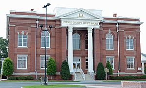
Pierce County Courthouse in Blackshear
|
|

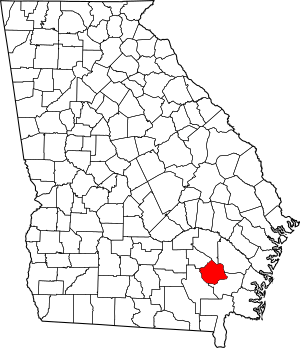
Location within the U.S. state of Georgia
|
|
 Georgia's location within the U.S. |
|
| Country | |
| State | |
| Founded | December 18, 1857 |
| Named for | Franklin Pierce |
| Seat | Blackshear |
| Largest city | Blackshear |
| Area | |
| • Total | 343 sq mi (890 km2) |
| • Land | 316 sq mi (820 km2) |
| • Water | 27 sq mi (70 km2) 7.8%% |
| Population | |
| • Estimate
(2018)
|
19,389 |
| • Density | 59/sq mi (23/km2) |
| Time zone | UTC−5 (Eastern) |
| • Summer (DST) | UTC−4 (EDT) |
| Congressional district | 1st |
Pierce County is a county located in the southeastern part of the U.S. state of Georgia. As of the 2010 census, the population was 18,758. The county seat is Blackshear.
Pierce County is part of the Waycross, GA Micropolitan Statistical Area.
Contents
History
Pierce County is named for Franklin Pierce, fourteenth President of the United States. It was created December 18, 1857, from Appling and Ware counties.
Geography
According to the U.S. Census Bureau, the county has a total area of 343 square miles (890 km2), of which 316 square miles (820 km2) is land and 27 square miles (70 km2) (7.8%) is water.
The northeastern third of Pierce County, bordered by a line from just west of Mershon to just south of Bristol, then south to just north of Blackshear, and then heading due east, is located in the Little Satilla River sub-basin of the St. Marys River-Satilla River basin. The southern two-thirds of the county is located in the Satilla River sub-basin of the St. Marys-Satilla River basin.
Major highways
Adjacent counties
- Appling County - north
- Wayne County - northeast
- Brantley County - southeast
- Ware County - west
- Bacon County - northwest
Demographics
| Historical population | |||
|---|---|---|---|
| Census | Pop. | %± | |
| 1860 | 1,973 | — | |
| 1870 | 2,778 | 40.8% | |
| 1880 | 4,538 | 63.4% | |
| 1890 | 6,379 | 40.6% | |
| 1900 | 8,100 | 27.0% | |
| 1910 | 10,749 | 32.7% | |
| 1920 | 11,934 | 11.0% | |
| 1930 | 12,522 | 4.9% | |
| 1940 | 11,800 | −5.8% | |
| 1950 | 11,112 | −5.8% | |
| 1960 | 9,678 | −12.9% | |
| 1970 | 9,281 | −4.1% | |
| 1980 | 11,897 | 28.2% | |
| 1990 | 13,328 | 12.0% | |
| 2000 | 15,636 | 17.3% | |
| 2010 | 18,758 | 20.0% | |
| 2018 (est.) | 19,389 | 3.4% | |
| U.S. Decennial Census 1790-1960 1900-1990 1990-2000 2010-2013 |
|||
2010 census
As of the 2010 United States Census, there were 18,758 people, 7,083 households, and 5,268 families living in the county. The population density was 59.3 inhabitants per square mile (22.9/km2). There were 7,986 housing units at an average density of 25.2 per square mile (9.7/km2). The racial makeup of the county was 86.9% white, 8.9% black or African American, 0.4% American Indian, 0.3% Asian, 0.1% Pacific islander, 2.1% from other races, and 1.4% from two or more races. Those of Hispanic or Latino origin made up 4.7% of the population. Of the 7,083 households, 37.7% had children under the age of 18 living with them, 55.7% were married couples living together, 13.6% had a female householder with no husband present, 25.6% were non-families, and 21.8% of all households were made up of individuals. The average household size was 2.63 and the average family size was 3.05. The median age was 38.4 years.
The median income for a household in the county was $37,062 and the median income for a family was $47,157. Males had a median income of $38,770 versus $26,510 for females. The per capita income for the county was $18,283. About 13.6% of families and 15.4% of the population were below the poverty line, including 20.3% of those under age 18 and 14.9% of those age 65 or over.
2020 census
| Race | Num. | Perc. |
|---|---|---|
| White (non-Hispanic) | 16,403 | 83.2% |
| Black or African American (non-Hispanic) | 1,597 | 8.1% |
| Native American | 41 | 0.21% |
| Asian | 82 | 0.42% |
| Other/Mixed | 595 | 3.02% |
| Hispanic or Latino | 998 | 5.06% |
As of the 2020 United States census, there were 19,716 people, 7,048 households, and 5,319 families residing in the county.
Communities
Cities
- Blackshear
- Offerman
- Patterson
- Waycross (a small part) Effective July 1, 2015, Waycross is no longer located nor allowed to be located in Pierce County, Georgia. Rep. Chad Nimmer introduced HB 523 during the 2015 Legislative Session without providing the required statutory notice to the City of Waycross. HB 523 de-annexed the portion of Waycross located in Pierce County and prevents the City of Waycross from coming back into Pierce County.
Unincorporated communities
- Blue Lake
- Bristol
- Hacklebarney
- Jot Em Down Store
- Mershon
- Otter Creek
- Sandy Bottom
- Walkerville
- Zirkle's Landing
See also
 In Spanish: Condado de Pierce (Georgia) para niños

