
Pierce County, North Dakota facts for kids
Quick facts for kids
Pierce County
|
|
|---|---|

|
|

Location within the U.S. state of North Dakota
|
|
 North Dakota's location within the U.S. |
|
| Country | |
| State | |
| Founded | March 11, 1887 (created) April 6, 1889 (organized) |
| Named for | Gilbert A. Pierce |
| Seat | Rugby |
| Largest city | Rugby |
| Area | |
| • Total | 1,082 sq mi (2,800 km2) |
| • Land | 1,019 sq mi (2,640 km2) |
| • Water | 64 sq mi (170 km2) 5.9% |
| Population
(2020)
|
|
| • Total | 3,990 |
| • Estimate
(2021)
|
3,953 |
| • Density | 3.688/sq mi (1.4238/km2) |
| Time zone | UTC−6 (Central) |
| • Summer (DST) | UTC−5 (CDT) |
| Congressional district | At-large |
Pierce County is a county in the U.S. state of North Dakota. As of the 2020 census, the population was 3,990. Its county seat is Rugby.
Contents
Geography
According to the U.S. Census Bureau, the county has a total area of 1,082 square miles (2,800 km2), of which 1,019 square miles (2,640 km2) is land and 64 square miles (170 km2) (5.9%) is water.
Major highways
 U.S. Highway 2
 U.S. Highway 52
 North Dakota Route 3
 North Dakota Route 60
 North Dakota Route 17
 North Dakota Route 19
Adjacent counties
- Rolette County (north)
- Towner County (northeast)
- Benson County (east)
- Wells County (southeast)
- Sheridan County (southwest)
- McHenry County (west)
- Bottineau County (northwest)
National protected area
- Buffalo Lake National Wildlife Refuge
Demographics
| Historical population | |||
|---|---|---|---|
| Census | Pop. | %± | |
| 1890 | 905 | — | |
| 1900 | 4,765 | 426.5% | |
| 1910 | 9,740 | 104.4% | |
| 1920 | 9,283 | −4.7% | |
| 1930 | 9,074 | −2.3% | |
| 1940 | 9,208 | 1.5% | |
| 1950 | 8,326 | −9.6% | |
| 1960 | 7,394 | −11.2% | |
| 1970 | 6,323 | −14.5% | |
| 1980 | 6,166 | −2.5% | |
| 1990 | 5,052 | −18.1% | |
| 2000 | 4,675 | −7.5% | |
| 2010 | 4,357 | −6.8% | |
| 2020 | 3,990 | −8.4% | |
| 2021 (est.) | 3,953 | −9.3% | |
| U.S. Decennial Census 1790-1960 1900-1990 1990-2000 2010-2020 |
|||
2010 census
As of the 2010 census, there were 4,357 people, 1,835 households, and 1,145 families in the county. The population density was 4.28/sqmi (1.65/km2). There were 2,199 housing units at an average density of 2.16/sqmi (0.83/km2). The racial makeup of the county was 94.1% white, 3.9% American Indian, 0.5% black or African American, 0.1% Asian, 0.7% from other races, and 0.8% from two or more races. Those of Hispanic or Latino origin made up 1.0% of the population. In terms of ancestry, 52.3% were German, 34.5% were Norwegian, 5.5% were Irish, and 2.0% were American.
Of the 1,835 households, 24.5% had children under the age of 18 living with them, 52.8% were married couples living together, 5.9% had a female householder with no husband present, 37.6% were non-families, and 34.3% of all households were made up of individuals. The average household size was 2.23 and the average family size was 2.86. The median age was 46.9 years.
The median income for a household in the county was $37,091 and the median income for a family was $55,304. Males had a median income of $39,511 versus $21,811 for females. The per capita income for the county was $18,575. About 6.4% of families and 12.9% of the population were below the poverty line, including 11.2% of those under age 18 and 19.2% of those age 65 or over.
Communities
Cities
Census-designated places
Townships
- Alexanter
- Antelope Lake
- Balta
- Elling
- Elverum
- Hagel
- Jefferson
- Meyer map
- Ness
- Reno Valley
- Rush Lake
- Torgerson
- Truman
- Tuscarora
- White
Images for kids
-
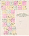
Outline map of Pierce County, North Dakota, 1910

See also
 In Spanish: Condado de Pierce (Dakota del Norte) para niños
