
Pierre, South Dakota facts for kids
Quick facts for kids
Pierre
Čhúŋkaške (Lakota)
|
|
|---|---|
|
State capital of South Dakota
|
|

The South Dakota State Capitol building in downtown Pierre
|
|
| Motto(s):
"On The River-On The Move"
|
|

Location within Hughes County in South Dakota
|
|

Pierre
Location in the United States
|
|
| Country | United States |
| State | South Dakota |
| County | Hughes |
| Founded | 1880 |
| Incorporated | 1883 |
| Named for | Pierre Chouteau Jr. |
| Area | |
| • Total | 13.05 sq mi (33.80 km2) |
| • Land | 13.03 sq mi (33.74 km2) |
| • Water | 0.02 sq mi (0.05 km2) 0.08% |
| Elevation | 1,453 ft (442 m) |
| Population
(2020)
|
|
| • Total | 14,091 |
| • Density | 1,081.42/sq mi (417.63/km2) |
| Time zone | UTC−6 (Central) |
| • Summer (DST) | UTC−5 (Central) |
| ZIP code |
57501
|
| Area code(s) | 605 Exchanges:224,773,776,945 |
| FIPS code | 46-49600 |
| GNIS feature ID | 1266887 |
| Website | City of Pierre |
Pierre ( peer; Lakota: Čhúŋkaške, lit. 'fort') is the capital city of South Dakota and the seat of Hughes County. The population was 14,091 at the 2020 census, making it the second-least populous state capital in the United States, following Montpelier, Vermont. It is the eighth-most populous city in South Dakota. Founded in 1880, it was selected as the state capital when the territory was admitted as a state. Pierre is the principal city of the Pierre Micropolitan Statistical Area, which includes all of Hughes and Stanley counties.
Contents
Geography

Pierre is located at 44°22′5″N 100°20′11″W / 44.36806°N 100.33639°W (44.367966, −100.336378).
According to the United States Census Bureau, the city has a total area of 13.07 square miles (33.85 km2), of which, 13.06 square miles (33.83 km2) is land and 0.01 square miles (0.03 km2) is water.
Pierre lies on rough river bluffs above the east bank of the Missouri River, overlooking its expanse. It is a few miles away from Lake Oahe, one of the largest man-made lakes in the world. Developed for flood control and irrigation, the lake has become a very popular fishing destination.
Climate
Pierre has a relatively dry, four-season, humid continental climate (Köppen Dfa), with long, dry, cold winters, hot summers, and brief spring and autumnal transitions; as with much of the southern half of the state, it lies in USDA Plant Hardiness Zone 5. The monthly daily average temperature ranges from 19.9 °F (−6.7 °C) in January to 75.4 °F (24.1 °C), though the diurnal temperature variation is significantly greater during summer than in winter. Snow primarily falls in light amounts, with the snowiest months being February and March, while the average seasonal total is 32 inches (0.81 m). In addition, there are 20 nights per year with lows below 0 °F (−17.8 °C), and cold conditions are often intensified by the high winds of the Great Plains. Summers often see spikes in temperature, with 6.4 days of highs above 100 °F (37.8 °C) and 36−37 days with highs above 90 °F (32.2 °C).
The beginning of both May and October represent the last and first, respectively, freezing nights of the cooler season. Precipitation is much lighter in the winter months than it is in late spring and summer, and totals about 20 inches (508 mm) annually. Extremes have ranged from −35 °F (−37 °C) on February 9, 1994 to 117 °F (47 °C) on July 15, 2006.
| Climate data for Pierre, South Dakota (Pierre Regional Airport), 1981−2010 normals | |||||||||||||
|---|---|---|---|---|---|---|---|---|---|---|---|---|---|
| Month | Jan | Feb | Mar | Apr | May | Jun | Jul | Aug | Sep | Oct | Nov | Dec | Year |
| Record high °F (°C) | 68 (20) |
75 (24) |
88 (31) |
98 (37) |
105 (41) |
112 (44) |
117 (47) |
114 (46) |
108 (42) |
98 (37) |
87 (31) |
77 (25) |
117 (47) |
| Average high °F (°C) | 30.0 (−1.1) |
34.9 (1.6) |
45.4 (7.4) |
59.7 (15.4) |
70.2 (21.2) |
80.0 (26.7) |
88.8 (31.6) |
87.3 (30.7) |
76.5 (24.7) |
61.0 (16.1) |
44.1 (6.7) |
31.3 (−0.4) |
59.1 (15.1) |
| Average low °F (°C) | 9.8 (−12.3) |
13.8 (−10.1) |
23.5 (−4.7) |
34.2 (1.2) |
45.7 (7.6) |
55.4 (13.0) |
61.9 (16.6) |
60.1 (15.6) |
49.2 (9.6) |
36.4 (2.4) |
23.3 (−4.8) |
12.1 (−11.1) |
35.6 (2.0) |
| Record low °F (°C) | −33 (−36) |
−35 (−37) |
−19 (−28) |
1 (−17) |
21 (−6) |
34 (1) |
42 (6) |
39 (4) |
21 (−6) |
4 (−16) |
−18 (−28) |
−31 (−35) |
−35 (−37) |
| Average precipitation inches (mm) | .42 (11) |
.59 (15) |
1.23 (31) |
1.81 (46) |
3.15 (80) |
3.57 (91) |
2.61 (66) |
1.80 (46) |
1.87 (47) |
1.65 (42) |
.76 (19) |
.55 (14) |
20.01 (508) |
| Average snowfall inches (cm) | 5.4 (14) |
6.0 (15) |
5.8 (15) |
3.5 (8.9) |
0 (0) |
0 (0) |
0 (0) |
0 (0) |
0 (0) |
.9 (2.3) |
4.8 (12) |
4.8 (12) |
31.3 (80) |
| Average precipitation days (≥ 0.01 in) | 5.7 | 4.7 | 6.3 | 8.2 | 10.2 | 10.7 | 9.2 | 7.4 | 6.8 | 6.8 | 5.9 | 5.8 | 87.7 |
| Average snowy days (≥ 0.1 in) | 5.1 | 3.8 | 3.5 | 1.9 | 0 | 0 | 0 | 0 | 0 | .6 | 3.1 | 4.3 | 22.3 |
| Source: NOAA (extremes 1933–present) | |||||||||||||
Demographics
| Historical population | |||
|---|---|---|---|
| Census | Pop. | %± | |
| 1890 | 3,235 | — | |
| 1900 | 2,306 | −28.7% | |
| 1910 | 3,656 | 58.5% | |
| 1920 | 3,209 | −12.2% | |
| 1930 | 3,659 | 14.0% | |
| 1940 | 4,322 | 18.1% | |
| 1950 | 5,715 | 32.2% | |
| 1960 | 10,088 | 76.5% | |
| 1970 | 9,699 | −3.9% | |
| 1980 | 11,973 | 23.4% | |
| 1990 | 12,906 | 7.8% | |
| 2000 | 13,876 | 7.5% | |
| 2010 | 13,646 | −1.7% | |
| 2020 | 14,091 | 3.3% | |
| U.S. Decennial Census 2018 Estimate |
|||
2010 census

As of the census of 2010, there were 13,646 people, 5,778 households, and 3,463 families living in the city. The population density was 1,044.9 inhabitants per square mile (403.4/km2). There were 6,159 housing units at an average density of 471.6 per square mile (182.1/km2). The racial makeup of the city was 85.1% White, 0.5% African American, 10.9% Native American, 0.6% Asian, 0.5% from other races, and 2.4% from two or more races. Hispanic or Latino people of any race were 1.9% of the population.
There were 5,778 households, of which 29.2% had children under the age of 18 living with them, 45.7% were married couples living together, 10.4% had a female householder with no husband present, 3.8% had a male householder with no wife present, and 40.1% were non-families. 35.0% of all households were made up of individuals, and 11% had someone living alone who was 65 years of age or older. The average household size was 2.23 and the average family size was 2.87.
The median age in the city was 39.3 years. 22.9% of residents were under the age of 18; 7.5% were between the ages of 18 and 24; 26.7% were from 25 to 44; 28.9% were from 45 to 64; and 13.9% were 65 years of age or older. The gender makeup of the city was 47.8% male and 52.2% female.
Transportation
Public transit is provided by River Cities Public Transit.
The city's Pierre Regional Airport is currently served by two commercial airlines.
Although in the center of the state, Pierre is one of only four state capitals not served by an Interstate highway (along with Dover, Delaware, Jefferson City, Missouri, and Juneau, Alaska). It is the only one that is not served by any expressways. The nearest Interstate highway is Interstate 90, about 34 mi (55 km) south of Pierre via the four-lane U.S. Highway 83.
The Rapid City, Pierre and Eastern Railroad runs east–west through the city. The railroad crosses the Missouri River on the Chicago and North Western Railroad Bridge.
In popular culture
In 2015, in honor of the Monopoly game's 80th birthday, Hasbro held an online vote in order to determine which cities would make it into an updated version of the "Here and Now: The US Edition" of the game. The top "Boardwalk" spot went to an unexpected contender: Pierre. It got the highest number of votes, beating out cities like New York, Los Angeles, Chicago, and Boston. The picture, which accompanied the name of the city in the balloting, was of the well-known Mt. Rushmore even though the sculpture is in Keystone, SD, some 150 miles to the west of Pierre.
Pierre is home to many attractions including the Oahe Dam and the world's largest Menards, a regional home improvement store.
Photo gallery
-
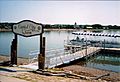
The Capital City Queen is a passenger leisure boat on the Pierre waterways.
-
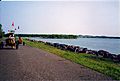
Many of Pierre's parks lie along the Missouri River.


Education
The Pierre School District oversees three elementary schools, a middle school and a high school, T. F. Riggs High School. St. Joseph, is a private Catholic elementary school. It is administered by the local parish and the Diocese of Sioux Falls. Other schools include For His Glory and the Pierre Indian Learning Center (a tribal school affiliated with the Bureau of Indian Education).
Notable people
- Angela Aames, actress
- Floyd Bannister, pitcher in Major League Baseball
- Joseph Bottum, writer
- Tom Brokaw, television journalist and author
- Robert Gleckler, actor
- Dusty Johnson, current U.S. Representative from South Dakota (born in Pierre in 1976).
- Byron S. Payne, Attorney General of South Dakota
- John Thune, current senior U.S. Senator from South Dakota (born in Pierre in 1961).
- Rex Robbins, actor
- Mike Rounds, current junior U.S. Senator from South Dakota and former Governor of South Dakota. (resident of Fort Pierre).
Images for kids
-

Huron (left) and Pierre (right) issued rival maps that claimed each as the best place voters should choose for the new state capital in 1890.
See also
 In Spanish: Pierre (Dakota del Sur) para niños
