
Pike County, Illinois facts for kids
Quick facts for kids
Pike County
|
|
|---|---|
|
County
|
|

Pike County Courthouse, Pittsfield
|
|

Location within the U.S. state of Illinois
|
|
 Illinois's location within the U.S. |
|
| Country | |
| State | |
| Founded | January 31, 1821 |
| Named for | Zebulon Pike |
| Seat | Pittsfield |
| Largest city | Pittsfield |
| Area | |
| • Total | 849 sq mi (2,200 km2) |
| • Land | 831 sq mi (2,150 km2) |
| • Water | 18 sq mi (50 km2) 2.1% |
| Population
(2010)
|
|
| • Total | 16,430 |
| • Estimate
(2018)
|
15,611 |
| • Density | 19.352/sq mi (7.472/km2) |
| Time zone | UTC−6 (Central) |
| • Summer (DST) | UTC−5 (CDT) |
| Congressional district | 18th |
Pike County is a county in the U.S. state of Illinois. According to the 2010 United States Census, it had a population of 16,430. Its county seat is Pittsfield.
Contents
History
Pike County was formed on January 31, 1821 out of Madison County. It was named in honor of Zebulon Pike, leader of the Pike expedition in 1806 to map out the south and west portions of the Louisiana Purchase. Pike served at the Battle of Tippecanoe, and was killed in 1813 in the War of 1812.
Prior to the coming of the first European settler to Pike County, French traders, hunters, and travelers passed through the native forests and prairies. Originally Pike County began on the south junction of the Illinois and Mississippi rivers. The east boundary was the Illinois River north to the Kankakee River to the Indiana State line on north to Wisconsin territorial line and then west to the Mississippi River to the original point at the south end. The first county seat was Cole's Grove, a post town, in what later became Calhoun County. The Gazetteer of Illinois and Missouri, published in 1822, mentioned Chicago as "a village of Pike County" containing 12 or 15 houses and about 60 or 70 inhabitants.
The New Philadelphia Town Site was listed on the National Register of Historic Places in 2005 and designated a National Historic Landmark in 2009. Founded by Frank McWorter, an early free black settler in Pike County, it was the first town founded by a black man in the United States. McWorter had invested in land there sight unseen after purchasing the first few members of his family out of slavery. In 1836 he founded the town of New Philadelphia, near Barry. He was elected mayor and lived there the rest of his life. With the sale of land, he made enough money to purchase the freedom of his children. After the railroad bypassed the town, its growth slowed and it was eventually abandoned in the 20th century. The town site is now an archaeological site.
In the early 21st century, Pike County acquired notability as a whitetail deer hunting center, especially for bowhunting.
-
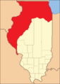
Pike County from the time of its creation to 1823
-
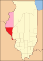
Pike County between 1823 and 1825, including a large tract of unorganized territory temporarily attached to it.
-
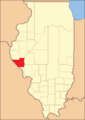
Pike County in 1825, reduced to its present borders.


Geography
According to the U.S. Census Bureau, the county has a total area of 849 square miles (2,200 km2), of which 831 square miles (2,150 km2) is land and 18 square miles (47 km2) (2.1%) is water.
Pike County is located on the highlands between the Illinois River on the eastern border, and the Mississippi River on the west. It has two interstate highways, I-72, with bridges spanning both rivers to enter the county and I-172 which only extends about 300 feet (91 m) into the county where it ends at its southern terminus with I-72.
Climate and weather
| Weather chart for Pittsfield, Illinois | |||||||||||||||||||||||||||||||||||||||||||||||
|---|---|---|---|---|---|---|---|---|---|---|---|---|---|---|---|---|---|---|---|---|---|---|---|---|---|---|---|---|---|---|---|---|---|---|---|---|---|---|---|---|---|---|---|---|---|---|---|
| J | F | M | A | M | J | J | A | S | O | N | D | ||||||||||||||||||||||||||||||||||||
|
1.7
33
15
|
1.8
40
20
|
3.2
51
30
|
3.9
64
42
|
4.1
74
52
|
3.3
82
62
|
4.1
86
66
|
3
85
63
|
3.2
78
54
|
2.9
66
43
|
3.4
51
31
|
2.6
38
21
|
||||||||||||||||||||||||||||||||||||
| temperatures in °F precipitation totals in inches source: The Weather Channel |
|||||||||||||||||||||||||||||||||||||||||||||||
|
Metric conversion
|
|||||||||||||||||||||||||||||||||||||||||||||||
In recent years, average temperatures in the county seat of Pittsfield have ranged from a low of 15 °F (−9 °C) in January to a high of 86 °F (30 °C) in July, although a record low of −25 °F (−32 °C) was recorded in February 1905 and a record high of 115 °F (46 °C) was recorded in July 1954. Average monthly precipitation ranged from 1.74 inches (44 mm) in January to 4.11 inches (104 mm) in May.
Major highways
 Interstate 72
 Interstate 172
 U.S. Route 36
 U.S. Route 54
 Illinois Route 57
 Illinois Route 96
 Illinois Route 106
 Illinois Route 107
 Illinois Route 100
Adjacent counties
- Adams County - north
- Brown County - northeast
- Scott County - east
- Morgan County - east
- Greene County - southeast
- Calhoun County - south
- Pike County, Missouri - southwest
- Ralls County, Missouri - west
- Marion County, Missouri - northwest
Pike County is one of the few counties in the United States to border as many as nine counties. Illinois has two such counties, with LaSalle County being the other.
Pike County in Illinois and Missouri are two of twenty-two counties or parishes in the United States with the same name to border each other across state lines. The others are Union Parish, Louisiana and Union County, Arkansas, Big Horn County, Montana and Big Horn County, Wyoming, Sabine County, Texas and Sabine Parish, Louisiana, Bristol County, Massachusetts and Bristol County, Rhode Island, Kent County, Delaware and Kent County, Maryland, Escambia County, Alabama and Escambia County, Florida, Teton County, Idaho and Teton County, Wyoming, Park County, Montana and Park County, Wyoming, San Juan County, New Mexico and San Juan County, Utah, and Vermilion County, Illinois and Vermillion County, Indiana. respectively. (Note, despite the different spellings, the source of the name is the same for Vermilion County, Illinois and Vermillion County, Indiana—the Vermillion River which flows through both counties.)
National protected area
Demographics
| Historical population | |||
|---|---|---|---|
| Census | Pop. | %± | |
| 1830 | 2,396 | — | |
| 1840 | 11,728 | 389.5% | |
| 1850 | 18,819 | 60.5% | |
| 1860 | 27,249 | 44.8% | |
| 1870 | 30,768 | 12.9% | |
| 1880 | 33,751 | 9.7% | |
| 1890 | 31,000 | −8.2% | |
| 1900 | 31,595 | 1.9% | |
| 1910 | 28,622 | −9.4% | |
| 1920 | 26,866 | −6.1% | |
| 1930 | 24,357 | −9.3% | |
| 1940 | 25,340 | 4.0% | |
| 1950 | 22,155 | −12.6% | |
| 1960 | 20,552 | −7.2% | |
| 1970 | 19,185 | −6.7% | |
| 1980 | 18,896 | −1.5% | |
| 1990 | 17,577 | −7.0% | |
| 2000 | 17,384 | −1.1% | |
| 2010 | 16,430 | −5.5% | |
| 2018 (est.) | 15,611 | −5.0% | |
| US Decennial Census 1790-1960 1900-1990 1990-2000 2010-2013 |
|||
As of the 2010 United States Census, there were 16,430 people, 6,639 households, and 4,527 families residing in the county. The population density was 19.8 inhabitants per square mile (7.6/km2). There were 7,951 housing units at an average density of 9.6 per square mile (3.7/km2). The racial makeup of the county was 96.9% white, 1.7% black or African American, 0.2% Asian, 0.2% American Indian, 0.2% from other races, and 0.7% from two or more races. Those of Hispanic or Latino origin made up 1.0% of the population. In terms of ancestry, 26.3% were German, 16.8% were American, 15.1% were English, and 13.4% were Irish.
Of the 6,639 households, 30.3% had children under the age of 18 living with them, 54.5% were married couples living together, 9.0% had a female householder with no husband present, 31.8% were non-families, and 27.8% of all households were made up of individuals. The average household size was 2.38 and the average family size was 2.87. The median age was 42.5 years.
The median income for a household in the county was $40,205 and the median income for a family was $50,426. Males had a median income of $39,071 versus $26,835 for females. The per capita income for the county was $19,996. About 11.3% of families and 15.4% of the population were below the poverty line, including 23.7% of those under age 18 and 11.2% of those age 65 or over.
Communities
Cities
Villages
Town
Unincorporated communities
Ghost town
Townships
- Atlas Township
- Barry Township
- Chambersburg Township
- Cincinnati Township
- Derry Township
- Detroit Township
- Fairmount Township
- Flint Township
- Griggsville Township
- Hadley Township
- Hardin Township
- Kinderhook Township
- Levee Township
- Martinsburg Township
- Montezuma Township
- Newburg Township
- New Salem Township
- Pearl Township
- Perry Township
- Pittsfield Township
- Pleasant Hill Township
- Pleasant Vale Township
- Ross Township
- Spring Creek Township
See also
 In Spanish: Condado de Pike (Illinois) para niños
