Plantation Island, Florida facts for kids
Quick facts for kids
Plantation Island, Florida
|
|
|---|---|

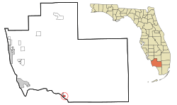
Location in Collier County and the state of Florida
|
|
| Country | |
| State | |
| County | |
| Area | |
| • Total | 0.59 sq mi (1.53 km2) |
| • Land | 0.58 sq mi (1.49 km2) |
| • Water | 0.01 sq mi (0.03 km2) |
| Elevation | 4 ft (1 m) |
| Population
(2020)
|
|
| • Total | 119 |
| • Density | 206.60/sq mi (79.76/km2) |
| Time zone | UTC-5 (Eastern (EST)) |
| • Summer (DST) | UTC-4 (EDT) |
| FIPS code | 12-57492 |
| GNIS feature ID | 0289027 |
Plantation Island is a census-designated place (CDP) in Collier County, Florida, United States. The population was 163 at the 2010 census. It is part of the Naples–Marco Island Metropolitan Statistical Area.
Contents
Geography
Plantation Island is located in southern Collier County at 25°50′47″N 81°22′6″W / 25.84639°N 81.36833°W (25.846346, -81.368274), on the shore of Chokoloskee Bay near the northwest end of Everglades National Park. It is bordered to the west by Everglades City.
According to the United States Census Bureau, the CDP has a total area of 0.58 square miles (1.5 km2), of which 0.012 square miles (0.03 km2), or 1.90%, is water.
Demographics
| Historical population | |||
|---|---|---|---|
| Census | Pop. | %± | |
| 2020 | 119 | — | |
|
|
|||
2020 census
| Race | Number | Percentage |
|---|---|---|
| White (NH) | 104 | 87.39% |
| Native American or Alaska Native (NH) | 1 | 0.84% |
| Some Other Race (NH) | 1 | 0.84% |
| Mixed/Multi-Racial (NH) | 5 | 4.2% |
| Hispanic or Latino | 8 | 6.72% |
| Total | 119 |
As of the 2020 United States census, there were 119 people, 14 households, and 0 families residing in the CDP.
See also
 In Spanish: Plantation Island para niños

