Pleasant Grove, Maryland facts for kids
Quick facts for kids
Pleasant Grove, Maryland
|
|
|---|---|

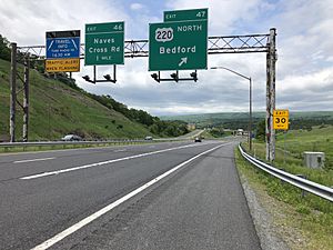
I-68/US 40 at US 220 in Pleasant Grove
|
|
| Country | |
| State | |
| County | |
| Area | |
| • Total | 1.60 sq mi (4.13 km2) |
| • Land | 1.60 sq mi (4.13 km2) |
| • Water | 0.00 sq mi (0.00 km2) |
| Elevation | 780 ft (240 m) |
| Population
(2020)
|
|
| • Total | 330 |
| • Density | 206.77/sq mi (79.84/km2) |
| Time zone | UTC−5 (Eastern (EST)) |
| • Summer (DST) | UTC−4 (EDT) |
| FIPS code | 24-62100 |
| GNIS feature ID | 2583672 |
Pleasant Grove is a census-designated place (CDP) in Allegany County, Maryland, United States. As of the 2010 census it had a population of 353.
Pleasant Grove is located east of Cumberland along Maryland Route 144 (Baltimore Pike), the old alignment of U.S. Route 40. Interstate 68, the new highway alignment, also runs through the CDP, with access via Exit 47 at the western end of the community.
Demographics
| Historical population | |||
|---|---|---|---|
| Census | Pop. | %± | |
| 2020 | 330 | — | |
| U.S. Decennial Census | |||
See also
 In Spanish: Pleasant Grove (Maryland) para niños

All content from Kiddle encyclopedia articles (including the article images and facts) can be freely used under Attribution-ShareAlike license, unless stated otherwise. Cite this article:
Pleasant Grove, Maryland Facts for Kids. Kiddle Encyclopedia.


