
Plymouth, New Hampshire facts for kids
Quick facts for kids
Plymouth, New Hampshire
|
||
|---|---|---|
|
Town
|
||

Town center (left to right): Plymouth Post Office, Rounds Hall of Plymouth State University (in background), Plymouth Congregational Church, Town Hall
|
||
|
||
| Motto(s):
Bridging the Lakes Region and the White Mountains
|
||

Location in Grafton County, New Hampshire
|
||
| Country | United States | |
| State | New Hampshire | |
| County | Grafton | |
| Incorporated | 1763 | |
| Named for | Plymouth Colony, Massachusetts | |
| Villages | Plymouth West Plymouth |
|
| Area | ||
| • Total | 28.6 sq mi (74.2 km2) | |
| • Land | 28.1 sq mi (72.8 km2) | |
| • Water | 0.5 sq mi (1.4 km2) 1.94% | |
| Elevation | 520 ft (160 m) | |
| Population
(2020)
|
||
| • Total | 6,682 | |
| • Density | 238/sq mi (91.8/km2) | |
| Time zone | UTC−5 (Eastern) | |
| • Summer (DST) | UTC−4 (Eastern) | |
| ZIP Code |
03264
|
|
| Area code(s) | 603 | |
| FIPS code | 33-62660 | |
| GNIS feature ID | 0873702 | |

Plymouth is a town in Grafton County, New Hampshire, United States, in the White Mountains Region. Plymouth is located at the confluence of the Pemigewasset and Baker rivers. The population was 6,682 at the 2020 census. The town is home to Plymouth State University, Speare Memorial Hospital, and Plymouth Regional High School.
The town's main village, where 4,730 people resided at the 2020 census (three-quarters of whom are college student age), is defined as the Plymouth census-designated place (CDP), and is located along U.S. Route 3, south of the confluence of the Baker and Pemigewasset rivers.
History
Plymouth was originally the site of an Abenaki village that was burned to the ground by Captain Thomas Baker in 1712. This was just one of the many British raids on American Indian settlements during Queen Anne's War. Part of a large plot of undivided land in the Pemigewasset Valley, the town was first named New Plymouth, after the original Plymouth Colony in Massachusetts. Colonial Governor Benning Wentworth granted Plymouth to settlers from Hollis, all of whom had been soldiers in the French and Indian War. Some had originally come from Plymouth, Massachusetts. The town was incorporated in 1763. Parts of Hebron and Campton were annexed in 1845 and 1860.
In 1806, then-lawyer Daniel Webster lost his first criminal case at the Plymouth courthouse, which now houses the Historical Society. The author Nathaniel Hawthorne, while on vacation in 1864 with former U.S. President Franklin Pierce, died in Plymouth at the second Pemigewasset House, which was later destroyed by fire in 1909. In the early 20th century, the Draper and Maynard Sporting Goods Company (D&M) sold products directly to the Boston Red Sox, and players such as Babe Ruth would regularly visit to pick out their equipment. The Plymouth Normal School was founded in 1871 out of the already existing Holmes Plymouth Academy, becoming the state's first teachers' college. It would later evolve into Plymouth Teachers' College in 1939, Plymouth State College in 1963, and finally Plymouth State University in 2003.
-
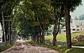
Main Street in 1908
-
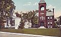
Congregational Church and Town Hall c. 1920
-
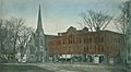
Kidder Block c. 1906
-
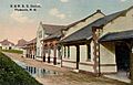
Railroad Station c. 1912


Geography

According to the United States Census Bureau, the town has a total area of 28.7 square miles (74.3 km2), of which
28.1 square miles (72.8 km2) is land and 0.6 square miles (1.6 km2) of it is water, comprising 2.00% of the town. Plymouth is drained by the Pemigewasset and Baker rivers and lies within the Merrimack River watershed. Plymouth Mountain, elevation 2,193 feet (668 m) above sea level, the highest point in Plymouth, is in the south, and the slopes of Tenney Mountain are in the west. (The 2,310-foot (700 m) summit of Tenney Mountain lies in the town of Groton.)
The main village of Plymouth, a census-designated place, has a total area of 3.8 square miles (9.8 km2). 3.7 sq mi (9.6 km2) is land and 0.1 sq mi (0.26 km2) of it (1.59%) is water.
Demographics
| Historical population | |||
|---|---|---|---|
| Census | Pop. | %± | |
| 1790 | 625 | — | |
| 1800 | 743 | 18.9% | |
| 1810 | 937 | 26.1% | |
| 1820 | 983 | 4.9% | |
| 1830 | 1,175 | 19.5% | |
| 1840 | 1,282 | 9.1% | |
| 1850 | 1,290 | 0.6% | |
| 1860 | 1,407 | 9.1% | |
| 1870 | 1,409 | 0.1% | |
| 1880 | 1,719 | 22.0% | |
| 1890 | 1,852 | 7.7% | |
| 1900 | 1,972 | 6.5% | |
| 1910 | 2,200 | 11.6% | |
| 1920 | 2,353 | 7.0% | |
| 1930 | 2,470 | 5.0% | |
| 1940 | 2,533 | 2.6% | |
| 1950 | 3,039 | 20.0% | |
| 1960 | 3,210 | 5.6% | |
| 1970 | 4,225 | 31.6% | |
| 1980 | 5,094 | 20.6% | |
| 1990 | 5,811 | 14.1% | |
| 2000 | 5,892 | 1.4% | |
| 2010 | 6,990 | 18.6% | |
| 2020 | 6,682 | −4.4% | |
| U.S. Decennial Census | |||
As of the census of 2010, there were 6,990 people, 1,953 households, and 947 families residing in the town. The population density was 248.8 people per square mile (96.0/km2). There were 2,231 housing units at an average density of 30.6 units/km2 (79.4 units/sq mi). The racial makeup of the town was 95.6% White, 1.0% African American, 0.3% Native American, 1.1% Asian, 0.5% some other race, and 1.6% from two or more races. Of the population 1.9% were Hispanic or Latino of any race.
There were 1,953 households, out of which 24.1% had children under the age of 18 living with them, 37.1% were headed by married couples living together, 8.6% had a female householder whose husband did not live with her, and 50.1% were non-families. 28.6% of all households were made up of individuals, and 9.9% were someone living alone who was 65 years of age or older. The average household size was 2.41, and the average family size was 2.89.

In the town, the population was spread out, with 12.0% under the age of 18, 50.4% from 18 to 24, 13.3% from 25 to 44, 16.3% from 45 to 64, and 8.0% who were 65 years of age or older. The median age was 21.7 years. For every 100 females, there were 109.2 males. For every 100 females age 18 and over, there were 108.6 males.
For the period 2009–2013, the estimated median annual income for a household in the town was $41,709, and the median income for a family was $79,453. Male full-time workers had a median income of $52,297 versus $28,851 for females. The per capita income for the town was $19,804. 22.5% of the population and 3.3% of families were below the poverty line. Out of the total people living in poverty, 4.3% were under the age of 18 and 9.8% were 65 or older.
Recreation
.jpg)
- Fox Pond Park
- Langdon Park
- Walter-Newton Natural Area
- Sutherland Hiking Trail (on Plymouth Mountain)
Sites of interest
- Plymouth Historical Museum
- Pease Public Library
- Lamson Library
- Boy Scout Fountain on the Common (one of only two Boy Scout Fountains in the USA)
- Fox Park
- Langdon Beach
- Smith Millennium Bridge (a covered bridge over the Baker River)
- The Flying Monkey Movie House and Performance Center (formerly the Plymouth Theater)
Notable people
- William F. Batchelder (1926–2019), New Hampshire Supreme Court associate justice
- Henry W. Blair (1834–1920), US senator, congressman
- Eliza Coupe (born 1981), actress (Happy Endings, Scrubs)
- Irene Clark Durrell (1852–1914), educator
- William A. Fletcher (1788–1852), Chief Justice of the Michigan Supreme Court, born in Plymouth
- Robert Frost (1874–1963), poet
- Harl Pease (1917–1942), World War II pilot, Medal of Honor recipient
- Daniel Webster (1782–1852), US senator, congressman from Massachusetts
See also
 In Spanish: Plymouth (Nuevo Hampshire) para niños
