Polk County, Missouri facts for kids
Quick facts for kids
Polk County
|
|
|---|---|

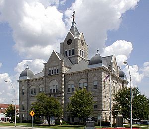
Polk County Courthouse in Bolivar
|
|

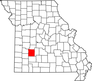
Location within the U.S. state of Missouri
|
|
 Missouri's location within the U.S. |
|
| Country | |
| State | |
| Founded | March 13, 1835 |
| Named for | Ezekiel Polk |
| Seat | Bolivar |
| Largest city | Bolivar |
| Area | |
| • Total | 642 sq mi (1,660 km2) |
| • Land | 636 sq mi (1,650 km2) |
| • Water | 6.9 sq mi (18 km2) 1.1% |
| Population
(2010)
|
|
| • Total | 31,137 |
| • Estimate
(2018)
|
32,201 |
| • Density | 48.50/sq mi (18.726/km2) |
| Time zone | UTC−6 (Central) |
| • Summer (DST) | UTC−5 (CDT) |
| Congressional district | 7th |
Polk County is a county located in the southwestern portion of the U.S. state of Missouri. As of the 2010 census, the population was 31,137. Its county seat is Bolivar. The county was organized January 5, 1835, and named for Ezekiel Polk.
Polk County is part of the Springfield, MO Metropolitan Statistical Area.
Contents
History
Polk County was organized and separated from Greene County on January 5, 1835. Its original boundaries were later reduced in creating Dade, Dallas, and Hickory counties. The name was suggested by a local pioneer, Ezekiel Madison Campbell, to honor his grandfather Ezekiel Polk, a colonel in the Revolutionary War and an early settler of western Tennessee.
Geography
According to the U.S. Census Bureau, the county has a total area of 642 square miles (1,660 km2), of which 636 square miles (1,650 km2) is land and 6.9 square miles (18 km2) (1.1%) is water.
Adjacent counties
- Hickory County (north)
- Dallas County (east)
- Greene County (south)
- Dade County (southwest)
- Cedar County (west)
- St. Clair County (northwest)
Major highways
Demographics
| Historical population | |||
|---|---|---|---|
| Census | Pop. | %± | |
| 1840 | 8,449 | — | |
| 1850 | 6,186 | −26.8% | |
| 1860 | 9,995 | 61.6% | |
| 1870 | 12,445 | 24.5% | |
| 1880 | 15,734 | 26.4% | |
| 1890 | 20,339 | 29.3% | |
| 1900 | 23,255 | 14.3% | |
| 1910 | 21,561 | −7.3% | |
| 1920 | 20,351 | −5.6% | |
| 1930 | 17,803 | −12.5% | |
| 1940 | 17,400 | −2.3% | |
| 1950 | 16,062 | −7.7% | |
| 1960 | 13,753 | −14.4% | |
| 1970 | 15,415 | 12.1% | |
| 1980 | 18,822 | 22.1% | |
| 1990 | 21,826 | 16.0% | |
| 2000 | 26,992 | 23.7% | |
| 2010 | 31,137 | 15.4% | |
| 2020 | 31,519 | 1.2% | |
| U.S. Decennial Census 1790-1960 1900-1990 1990-2000 2010-2015 |
|||
As of the census of 2000, there were 26,992 people, 9,917 households, and 7,140 families residing in the county. The population density was 42 people per square mile (16/km2). There were 11,183 housing units at an average density of 18 per square mile (7/km2). The racial makeup of the county was 97.26% White, 0.45% Black or African American, 0.67% Native American, 0.19% Asian, 0.03% Pacific Islander, 0.33% from other races, and 1.06% from two or more races. Approximately 1.30% of the population were Hispanic or Latino of any race.
There were 9,917 households, out of which 33.00% had children under the age of 18 living with them, 60.50% were married couples living together, 8.20% had a female householder with no husband present, and 28.00% were non-families. 23.20% of all households were made up of individuals, and 10.70% had someone living alone who was 65 years of age or older. The average household size was 2.56 and the average family size was 3.02.
In the county, the population was spread out, with 25.70% under the age of 18, 12.60% from 18 to 24, 25.50% from 25 to 44, 20.80% from 45 to 64, and 15.30% who were 65 years of age or older. The median age was 35 years. For every 100 females, there were 94.90 males. For every 100 females age 18 and over, there were 90.90 males.
The median income for a household in the county was $29,656, and the median income for a family was $35,843. Males had a median income of $25,383 versus $18,799 for females. The per capita income for the county was $13,645. About 11.10% of families and 16.30% of the population were below the poverty line, including 20.00% of those under age 18 and 12.00% of those age 65 or over.
Communities
Cities
- Bolivar (county seat)
- Fair Play
- Humansville
- Pleasant Hope
Villages
Unincorporated communities
Townships
Polk County is divided into 22 townships:
- Campbell Township
- Cliquot Township
- East Looney Township
- East Madison Township
- Flemington Township
- Jackson Township
- Jefferson Township
- Johnson Township
- McKinley Township
- Mooney Township
- North Benton Township
- North Green Township
- Northeast Marion Township
- Northwest Marion Township
- South Benton Township
- South Green Township
- Southeast Marion Township
- Southwest Marion Township
- Union Township
- West Looney Township
- West Madison Township
- Wishart Township
Education
Public libraries
- Polk County Public Library
See also
 In Spanish: Condado de Polk (Misuri) para niños

