Polk County, Tennessee facts for kids
Quick facts for kids
Polk County
|
|
|---|---|

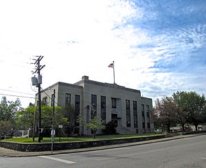
Polk County Courthouse in Benton
|
|

Location within the U.S. state of Tennessee
|
|
 Tennessee's location within the U.S. |
|
| Country | |
| State | |
| Founded | November 28, 1839 |
| Named for | James K. Polk |
| Seat | Benton |
| Largest town | Benton |
| Area | |
| • Total | 442 sq mi (1,140 km2) |
| • Land | 435 sq mi (1,130 km2) |
| • Water | 7.7 sq mi (20 km2) 1.7%% |
| Population
(2020)
|
|
| • Total | 17,544 |
| • Density | 40.33/sq mi (15.57/km2) |
| Time zone | UTC−5 (Eastern) |
| • Summer (DST) | UTC−4 (EDT) |
| Congressional district | 3rd |
Polk County is a county located in the southeastern corner of the U.S. state of Tennessee. As of the 2020 United States census, its population was 17,544. Its county seat is Benton. The county was created on November 28, 1839, from parts of Bradley and McMinn counties, after final removal of most Cherokee from the region that year. The county was named after then-governor (and future president) James K. Polk. Polk County is included in the Cleveland, Tennessee Metropolitan Area Statistical Area, which is also included in the Chattanooga–Cleveland–Dalton, TN–GA–AL Combined Statistical Area.
Contents
Geography
According to the U.S. Census Bureau, the county has a total area of 442 square miles (1,140 km2), of which 435 square miles (1,130 km2) is land and 7.7 square miles (20 km2) (1.7%) is water. The total area is 1.65% water. Located in the extreme southeastern corner of Tennessee, it is the state's only county to share borders with both Georgia and North Carolina.
Much of the terrain of eastern Polk County is mountainous, including Big Frog Mountain, constituting part of the southern Appalachian Mountains. Large tracts of Polk County are part of the Cherokee National Forest. The Ocoee River, site of whitewater slalom events in the Atlanta 1996 Summer Olympic Games, runs through Polk County and is vital to one of the county's major industries, whitewater rafting. The calmer Hiwassee River, a tributary of the Tennessee River which flows through northern Polk County, is also used for rafting and tubing.
Adjacent counties
- Monroe County (northeast)
- Cherokee County, North Carolina (east)
- Fannin County, Georgia (southeast)
- Murray County, Georgia (southwest)
- Bradley County (west)
- McMinn County (northwest)
National protected areas
- Big Frog Wilderness (part)
- Cherokee National Forest (part)
State protected areas
- William L. Davenport Refuge
- Ducktown Basin Museum and Burra Burra Mine (state historic site)
- Fourth Fractional Township Wildlife Management Area
- Hiwassee/Ocoee Scenic River State Park
Demographics
| Historical population | |||
|---|---|---|---|
| Census | Pop. | %± | |
| 1840 | 3,570 | — | |
| 1850 | 6,338 | 77.5% | |
| 1860 | 8,726 | 37.7% | |
| 1870 | 7,369 | −15.6% | |
| 1880 | 7,269 | −1.4% | |
| 1890 | 8,361 | 15.0% | |
| 1900 | 11,357 | 35.8% | |
| 1910 | 14,116 | 24.3% | |
| 1920 | 14,243 | 0.9% | |
| 1930 | 15,686 | 10.1% | |
| 1940 | 15,473 | −1.4% | |
| 1950 | 14,074 | −9.0% | |
| 1960 | 12,160 | −13.6% | |
| 1970 | 11,669 | −4.0% | |
| 1980 | 13,602 | 16.6% | |
| 1990 | 13,643 | 0.3% | |
| 2000 | 16,050 | 17.6% | |
| 2010 | 16,825 | 4.8% | |
| 2020 | 17,544 | 4.3% | |
| U.S. Decennial Census 1790-1960 1900-1990 1990-2000 2010-2014 |
|||
2020 census
| Race | Number | Percentage |
|---|---|---|
| White (non-Hispanic) | 16,313 | 92.98% |
| Black or African American (non-Hispanic) | 61 | 0.35% |
| Native American | 59 | 0.34% |
| Asian | 33 | 0.19% |
| Pacific Islander | 10 | 0.06% |
| Other/Mixed | 771 | 4.39% |
| Hispanic or Latino | 297 | 1.69% |
As of the 2020 United States census, there were 17,544 people, 7,383 households, and 5,239 families residing in the county.
2010 census
As of the census of 2010, there were 16,825 people, 6,653 households, and 4,755 families residing in the county. The population density was 38.7 people per square mile. There were 7,991 housing units at an average density of 18.4 per square mile. The racial makeup of the county was 97.53% White, 0.38% Native American, 0.30% African American, 0.14% Asian, 0.02% Pacific Islander, and 1.21% from two or more races. Those of Hispanic or Latino origins, regardless of race, constituted 1.38% of the population.
There were 6,653 households, out of which 26.10% had children under the age of 18 living with them, 56.60% were married couples living together, 9.00% had a female householder with no husband present, and 26.30% were non-families. 25.0% of all households were made up of individuals, and 11.20% had someone living alone who was 65 years of age or older. The average household size was 2.49 and the average family size was 2.96.
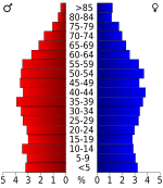
In the county, the population was spread out, with 22.14% under the age of 18, 5.0% from 20 to 24, 10.20% from 25 to 34, 21.60% from 35 to 49, 21.70% from 50 to 64, and 17.10% who were 65 years of age or older. The median age was 42.5 years.
In 2000, the median income for a household in the county was $29,643, and the median income for a family was $36,370. Males had a median income of $27,703 versus $21,010 for females. The per capita income for the county was $16,025. About 9.70% of families and 13.00% of the population were below the poverty line, including 13.80% of those under age 18 and 18.40% of those age 65 or over.
Communities
Cities
Town
- Benton (county seat)
Ghost Towns
- Probst
- Bonnie
- McFarland
- Sylco
- Hidgon's Store
- Alaculsy
- Old Dutch Settlement
- Broad Shoals
- Smith Creek Village
- Apalachia
- Apalachia Station
Unincorporated Communities
Economy
For most of its history, the mines in the Copper Basin were the largest source of employment in Polk County. As the copper mining industry began to decline, tourism associated with the Ocoee and Hiwassee Rivers began to overtake the copper mines as the largest industry in the county. The first rafting company on the Hiwassee was established in 1969. The shutdown of Ocoee Dam No. 2 to repair the flume line in September 1976 first made possible the rafting of the river's rapids, and several rafting companies were established during this time up until 1983, when the reconstruction was complete. Before the reconstruction project was complete, a struggle ensued between TVA and the rafting companies over usage of the river, which culminated in a 1984 agreement with TVA to schedule periodic releases of water through the dam at certain times of the year to allow for whitewater rafting. This agreement, set to expire in 2019, was renewed in 2017. During the same time, commercial rafting of the Hiwassee also greatly increased. Today, tourism associated with rafting, kayaking, and canoeing the Hiwassee and Ocoee Rivers is the largest sector of Polk County's economy, drawing more than 250,000 people to the area annually. The Ocoee River is now the most rafted river in the United States, with about 250,000 visitors annually, and more than 100,000 people raft the Hiwaseee River each year. Both rivers are ranked as two of the most visited tourist attractions in Tennessee.
Education
Public schools in Polk County are operated by the Polk County Schools district. High Schools include Copper Basin High School and Polk County High School. The district has one middle school, Chilhowee Middle. The district also has three elementary schools, Benton Elementary, South Polk Elementary and Copper Basin Elementary.
Transportation
Highways
Air
Polk County is served by Martin Campbell Field, a general aviation airport. The Chilhowee Gliderport is an FAA-licensed gliderport located near Benton.
Notable people
- Stan Beaver, musician.
- Landrum Bolling, journalist.
- Randy Buehler, game developer.
- Joel Eaves, basketball coach.
- G. Earl Guinn, university president.
- Elizabeth Hamer Kegan, librarian.
- John E. Hutton, U.S. representative.
- J. Chris Newton, politician.
- Rick Tyler, white supremacist.
Images for kids
See also
 In Spanish: Condado de Polk (Tennessee) para niños


