
Pontine Islands facts for kids

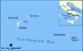
Map of the Pontine Islands
|
|
| Geography | |
|---|---|
| Location | Tyrrhenian Sea |
| Coordinates | 40°53′5″N 13°9′15″E / 40.88472°N 13.15417°E |
| Administration | |
| Demographics | |
| Demonym | Ponzesi |
| Population | 4076 |
The Pontine Islands are a small archipelago along the Gulf of Gaeta, in the Tyrrhenian Sea off the west coast of Italy, at about 30–40 km (19–25 mi) from the European continent.
The islands were named after the largest island in the group, Ponza.
Contents
Geography
The archipelago has an area of about 11.91 km2 (4.60 sq mi) with a resident population of about 4,076 persons. During the summers, many people visit the islands. They islands, Ponza and Ventotene, can be reached by ferry or hydrofoil.
The highest point in the archipelago is Monte Guardia in the southern end of the Ponza island; it is 283 m (928 ft) high.
Muncipalities
The archipelago has six islands and several islets divided in two groups, part of two comuni of the Latina province:
| Comune | Group | Islands | Population (2016) |
Area (km²) |
Density (inhab./km²) |
|---|---|---|---|---|---|
| Ponza | Northwestern group | Ponza, Palmarola, Zannone, Gavi | 3,337 | 10.16 | 328.4 |
| Ventotene | Southeastern group | Ventotene, Santo Stefano | 739 | 1.75 | 422.3 |
| Total | 4,076 | 11.91 | 342.2 | ||
Gallery
.png)


Images for kids
-
The Pontine Islands.
See also
 In Spanish: Islas Pontinas para niños
