
Port Kembla, New South Wales facts for kids
Quick facts for kids Port KemblaWollongong, New South Wales |
|||||||||||||||
|---|---|---|---|---|---|---|---|---|---|---|---|---|---|---|---|

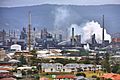
View of Port Kembla from Hill 60 Park looking North West at sunset
|
|||||||||||||||

Port Kembla
Location in New South Wales
|
|||||||||||||||
| Population | 5,014 (2016 census) | ||||||||||||||
| Postcode(s) | 2505 | ||||||||||||||
| Time zone | AEST (UTC+10) | ||||||||||||||
| • Summer (DST) | AEDT (UTC+11) | ||||||||||||||
| Location | 112 km (70 mi) S of Sydney | ||||||||||||||
| LGA(s) | City of Wollongong | ||||||||||||||
| State electorate(s) | Wollongong | ||||||||||||||
| Federal Division(s) | Cunningham | ||||||||||||||
|
|||||||||||||||
Port Kembla is a suburb of Wollongong 8 km south of the CBD and part of the Illawarra region of New South Wales. The suburb comprises a seaport, industrial complex (one of the largest in Australia), a small harbour foreshore nature reserve, and a small commercial sector. It is situated on the tip of Red Point: its first European sighting was by Captain James Cook in 1770. The name "Kembla" is an Aboriginal word meaning "plenty [of] wild fowl".
Contents
History
Before Port Kembla was an industrial suburb of Wollongong, it was a town with a remarkably self-sufficient society, a growing commercial centre, and a vibrant civic life. Town subdivision began in 1908, and by 1921 there were 1622 residents. Economic expansion propelled further population growth. Port Kembla derives its name from its proximity to Mount Kembla.
Industrial change
A copper smelter and refinery, the Electrolytic Refinery and Smelting Company of Australia, began production in 1908, followed by the opening of Metal Manufactures in 1917 and finally the arrival of the Hoskins Iron and Steel Works in 1927. The works became Australian Iron and Steel the following year.
By 1947 the town's population has increased to 4,960 with smaller satellite suburbs such as Cringila and Lake Heights, mushrooming on its fringes. That year, 1947, marked the climax of a local campaign for municipal autonomy which was ultimately thwarted by the creation of a Greater City of Wollongong. In the post-Second World War period there was an inexorable decline of a 'Port Kembla' society as local town boundaries were slowly but surely absorbed into a more Wollongong-focused or regional identity.
Multiculturalism
Despite the decline from the heyday of the 1920s, the town experienced major social and demographic change in the 1950s and 1960s. Waves of migrants, mostly from the United Kingdom, Italy, Macedonia and Germany, moved to the town. During this period, Port Kembla was on the cusp of changes affecting Australian society generally as new ethic and cultural influences found a place in local society. With its long migration history accommodating waves of migrant workers and their families, Port Kembla is still one of the most culturally diverse suburbs in New South Wales.
Hill 60
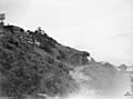
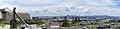
Port Kembla's highest point, Hill 60, overlooks the Five Islands and Red Point. Hill 60, originally the site of an Aboriginal settlement, was used by the army during World War II to make a coastal gun emplacement known as Illowra Battery. In September 1942, Aboriginal inhabitants were forcibly evicted from the area. It has remained in the army's ownership and is now a public lookout reserve, despite a vigorous campaign to return some of the land to its Aboriginal owners. Although not technically open to tourists, the tunnels are open, and can be explored by foot. The entrance to the tunnels is located almost under the coastguard tower on Hill 60, and can be seen down the left when standing at the information board, facing southeast.
-
Dated: 1944 No. 2 gun Illowra Battery, Showing its original BL 6 inch Mk XI gun
-
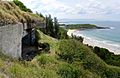
Gun position No. 2 at Illowra Battery, which formed part of the Kembla Fortress defences in World War II


Climate
Port Kembla has a warm oceanic climate (Cfb) with humid summers and mild, crispy winters. The suburb enjoys abundant sunshine, getting 111.4 clear days, annually.
| Climate data for Port Kembla (1957-1976) | |||||||||||||
|---|---|---|---|---|---|---|---|---|---|---|---|---|---|
| Month | Jan | Feb | Mar | Apr | May | Jun | Jul | Aug | Sep | Oct | Nov | Dec | Year |
| Record high °C (°F) | 41.9 (107.4) |
36.1 (97.0) |
39.4 (102.9) |
32.5 (90.5) |
29.4 (84.9) |
25.6 (78.1) |
25.8 (78.4) |
28.3 (82.9) |
35.0 (95.0) |
35.0 (95.0) |
39.2 (102.6) |
39.8 (103.6) |
41.9 (107.4) |
| Average high °C (°F) | 24.1 (75.4) |
24.4 (75.9) |
24.1 (75.4) |
22.4 (72.3) |
19.4 (66.9) |
17.5 (63.5) |
16.7 (62.1) |
17.3 (63.1) |
19.2 (66.6) |
20.7 (69.3) |
22.4 (72.3) |
23.4 (74.1) |
21.0 (69.8) |
| Average low °C (°F) | 18.4 (65.1) |
18.7 (65.7) |
18.0 (64.4) |
15.7 (60.3) |
12.7 (54.9) |
10.9 (51.6) |
9.8 (49.6) |
10.3 (50.5) |
11.8 (53.2) |
13.7 (56.7) |
15.3 (59.5) |
17.1 (62.8) |
14.4 (57.9) |
| Record low °C (°F) | 13.3 (55.9) |
13.0 (55.4) |
10.6 (51.1) |
10.0 (50.0) |
5.6 (42.1) |
5.3 (41.5) |
1.1 (34.0) |
2.2 (36.0) |
2.2 (36.0) |
7.2 (45.0) |
9.2 (48.6) |
10.0 (50.0) |
1.1 (34.0) |
| Average precipitation mm (inches) | 116.1 (4.57) |
157.5 (6.20) |
183.7 (7.23) |
92.9 (3.66) |
89.0 (3.50) |
140.3 (5.52) |
62.6 (2.46) |
87.7 (3.45) |
55.0 (2.17) |
108.0 (4.25) |
94.3 (3.71) |
90.4 (3.56) |
1,260.6 (49.63) |
| Average precipitation days | 11.6 | 12.5 | 13.4 | 9.1 | 8.0 | 9.7 | 7.4 | 9.5 | 8.2 | 11.2 | 11.1 | 11.0 | 122.7 |
| Average relative humidity (%) | 75 | 76 | 74 | 68 | 62 | 61 | 57 | 57 | 61 | 67 | 67 | 72 | 67 |
Sports and leisure
Sporting teams
Port Kembla has both junior and senior teams in local popular sporting leagues such as:
- Port Kembla Rugby League in the Illawarra Division Rugby league
Home grounds are Noel Mulligan Oval
- Port Kembla Cricket Club in the Cricket Illawarra Competition
Home grounds are King George V Park
- Port Kembla Soccer Club in the Illawarra Football Association
Home grounds are Darcy Wentworth Park Home grounds are Kully Bay Park.
Port Kembla Rugby league, Port Kembla Soccer Club and Port Kembla AFL home grounds are not located in Port Kembla, they all play in parks across Warrawong.
Parks and beaches
Port Kembla has a number of parks, nature reserves, beaches and a Saltwater Olympic pool:
- King George V Park
A foreshore park located in walking distance from Port Kembla Beach. Used in summer for Port Kembla Cricket Club home games.
- Hill 60 Park
A popular take off area for hang gliders and para gliders, Hill 60 Park has BBQ facilities as well as picnic shelters, seats and tables positioned to enjoy the scenic views.
- Port Kembla Beach (Or Perkins Beach)
An award winning beach, seasonally patrolled from September to April and home to the Port Kembla Surf Life Saving Club. It's beach code is nsw379A and it has a Surf Life Saving Australia general hazard rating of 7/10
- Fishermans Beach
A small sheltered beach at the bottom of Hill 60's eastern side facing the Five Islands Nature Reserve.
- North Port Kembla Beach
Also known by locals as MM Beach for its close proximity to the Metal Manufacturers site on Gloucester Boulevard. Remnants of a tidal rock pool are still standing near the southern end of the beach below the headland.
Three people died after being washed into rough surf at the popular rock fishing spot on Friday 22 January 2021.
Public transport
Train
Port Kembla has two railway stations on the Port Kembla branch of the NSW TrainLink South Coast Line.
Port Kembla railway station is the terminus of the branch line, and serves the residential area of Port Kembla. Port Kembla North serves the industrial area of the suburb. The station is the nearest to the BHP site in the area.
Both stations have a one sided platform, with the platform at Port Kembla used for terminating trains. The stations are served by approximately one train per hour, usually a local service to Thirroul, but extra direct trains to and from Sydney are provided in the peak hours.
-
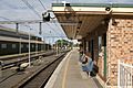
Port Kembla station
-
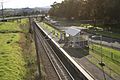
Port Kembla North station


Bus
Premier Illawarra runs three routes to and from Port Kembla railway station:
- 34 – to Wollongong via Berkeley
- 43 – to Dapto
- 65 – to North Beach
Images for kids
-
BlueScope steelworks
-
Port Kembla Harbour, taken from Breakwater Battery

