
Isle of Skye facts for kids
| Gaelic name | An t-Eilean Sgitheanach |
|---|---|
| Norse name | Skíð |
| Meaning of name | Etymology unclear |
_-_geograph.org.uk_-_1353645.jpg) Bank Street, Portree |
|
| OS grid reference | NG452319 |
| Coordinates | 57°18′25″N 6°13′48″W / 57.307°N 6.230°W |
| Physical geography | |
| Island group | Skye |
| Area | 1,656 km2 (639 sq mi) |
| Area rank | 2 |
| Highest elevation | Sgùrr Alasdair 993 metres (3,258 ft) |
| Administration | |
| Sovereign state | United Kingdom |
| Country | Scotland |
| Council area | Highland |
| Demographics | |
| Population | 10,008 |
| Population density | 6.04 people/km2 |
| Largest settlement | Portree |
The Isle of Skye, commonly known as Skye, is the largest and northernmost of the major islands in the Inner Hebrides of Scotland. The island's peninsulas radiate from a mountainous centre dominated by the Cuillin, the rocky slopes of which provide some of the most dramatic mountain scenery in the country. Although it has been suggested that the Gaelic Sgitheanach describes a winged shape there is no definitive agreement as to the name's origins.
The island has been occupied since the Mesolithic period, and its history includes a time of Norse rule and a long period of domination by Clan MacLeod and Clan Donald. The 18th century Jacobite risings led to the breaking up of the clan system and subsequent Clearances that replaced entire communities with sheep farms, some of which also involved forced emigrations to distant lands. Resident numbers declined from over 20,000 in the early 19th century to just under 9,000 by the closing decade of the 20th century. Skye's population increased by 4 per cent between 1991 and 2001. About a third of the residents were Gaelic speakers in 2001, and although their numbers are in decline, this aspect of island culture remains important.
The main industries are tourism, agriculture, fishing and forestry. Skye is part of the Highland Council local government area. The island's largest settlement is Portree, which is also its capital, known for its picturesque harbour. There are links to various nearby islands by ferry and, since 1995, to the mainland by a road bridge. The climate is mild, wet and windy. The abundant wildlife includes the golden eagle, red deer and Atlantic salmon. The local flora are dominated by heather moor, and there are nationally important invertebrate populations on the surrounding sea bed. Skye has provided the locations for various novels and feature films and is celebrated in poetry and song.
Contents
Geography


At 1,656 square kilometres (639 sq mi), Skye is the second-largest island in Scotland after Lewis and Harris. The coastline of Skye is a series of peninsulas and bays radiating out from a centre dominated by the Cuillin hills (Gaelic: An Cuiltheann). Malcolm Slesser suggested that its shape "sticks out of the west coast of northern Scotland like a lobster's claw ready to snap at the fish bone of Harris and Lewis" and W. H. Murray, commenting on its irregular coastline, stated that "Skye is sixty miles [100 km] long, but what might be its breadth is beyond the ingenuity of man to state". Martin Martin, a native of the island, reported on it at length in a 1703 publication. His geological observations included a note that:
There are marcasites black and white, resembling silver ore, near the village Sartle: there are likewise in the same place several stones, which in bigness, shape, &c., resemble nutmegs, and many rivulets here afford variegated stones of all colours. The Applesglen near Loch-Fallart has agate growing in it of different sizes and colours; some are green on the outside, some are of a pale sky colour, and they all strike fire as well as flint: I have one of them by me, which for shape and bigness is proper for a sword handle. Stones of a purple colour flow down the rivulets here after great rains.
—Martin Martin, A Description of The Western Islands of Scotland.
The Black Cuillin, which are mainly composed of basalt and gabbro, include twelve Munros and provide some of the most dramatic and challenging mountain terrain in Scotland. The ascent of Sgùrr a' Ghreadaidh is one of the longest rock climbs in Britain and the Inaccessible Pinnacle is the only peak in Scotland that requires technical climbing skills to reach the summit. Nearby Sgùrr Alasdair, meanwhile, is the tallest mountain on any Scottish island. These hills make demands of the hill walker that exceed any others found in Scotland and a full traverse of the Cuillin ridge may take 15–20 hours. The Red Hills (Gaelic: Am Binnean Dearg) to the south are also known as the Red Cuillin. They are mainly composed of granite that has weathered into more rounded hills with many long scree slopes on their flanks. The highest point of these hills is Glamaig, one of only two Corbetts on Skye.
The northern peninsula of Trotternish is underlain by basalt, which provides relatively rich soils and a variety of unusual rock features. The Kilt Rock is named after the tartan-like patterns in the 105 metres (344 ft) cliffs. The Quiraing is a spectacular series of rock pinnacles on the eastern side of the main spine of the peninsula and further south is the rock pillar of the Old Man of Storr. The view of the Quiraing and the Old Man of Storr is one of the most iconic in all of Scotland, and is frequently used on calendars and tourism guides and brochures.
Beyond Loch Snizort to the west of Trotternish is the Waternish peninsula, which ends in Ardmore Point's double rock arch. Duirinish is separated from Waternish by Loch Dunvegan, which contains the island of Isay. The loch is ringed by sea cliffs that reach 295 metres (967 ft) at Waterstein Head. Oolitic loam provides good arable land in the main valley. Lochs Bracadale and Harport and the island of Wiay lie between Duirinish and Minginish, which includes the narrower defiles of Talisker and Glen Brittle and whose beaches are formed from black basaltic sands. Strathaird is a relatively small peninsula close to the Cuillin hills with only a few crofting communities, the island of Soay lies offshore. The bedrock of Sleat in the south is Torridonian sandstone, which produces poor soils and boggy ground, although its lower elevations and relatively sheltered eastern shores enable a lush growth of hedgerows and crops. The islands of Raasay, Rona, Scalpay and Pabay all lie to the north and east between Skye and the mainland.
Towns and villages


Portree in the north at the base of Trotternish is the largest settlement (estimated population 2,264 in 2011) and is the main service centre on the island. Broadford, the location of the island's only airstrip, is on the east side of the island and Dunvegan in the north-west is well known for its castle and the nearby Three Chimneys restaurant. The 18th-century Stein Inn on the Waternish coast is the oldest pub on Skye. Kyleakin is linked to Kyle of Lochalsh on the mainland by the Skye Bridge, which spans the narrows of Loch Alsh. Uig, the port for ferries to the Outer Hebrides, is on the west of the Trotternish peninsula and Edinbane is between Dunvegan and Portree. Much of the rest of the population lives in crofting townships scattered around the coastline.
Climate
The influence of the Atlantic Ocean and the Gulf Stream create a mild oceanic climate. Temperatures are generally cool, averaging 6.5 °C (43.7 °F) in January and 15.4 °C (59.7 °F) in July at Duntulm in Trotternish. Snow seldom lies at sea level and frosts are less frequent than on the mainland. Winds are a limiting factor for vegetation. South-westerlies are the most common and speeds of 128 km/h (80 mph) have been recorded. High winds are especially likely on the exposed coasts of Trotternish and Waternish. In common with most islands of the west coast of Scotland, rainfall is generally high at 1,500–2,000 mm (59–79 in) per annum and the elevated Cuillin are wetter still. Variations can be considerable, with the north tending to be drier than the south. Broadford, for example, averages more than 2,870 mm (113 in) of rain per annum. Trotternish typically has 200 hours of bright sunshine in May, the sunniest month. On 28 December 2015, the temperature reached 15 °C, beating the previous December record of 12.9 °C, set in 2013. On 9 May 2016, a temperature of 26.7 °C (80.1 °F) was recorded at Lusa in the south-east of the island.
| Climate data for Duntulm, Skye | |||||||||||||
|---|---|---|---|---|---|---|---|---|---|---|---|---|---|
| Month | Jan | Feb | Mar | Apr | May | Jun | Jul | Aug | Sep | Oct | Nov | Dec | Year |
| Record high °C (°F) | 13.5 (56.3) |
12.5 (54.5) |
16.7 (62.1) |
22.3 (72.1) |
26.7 (80.1) |
24.5 (76.1) |
25.9 (78.6) |
25.6 (78.1) |
22.1 (71.8) |
19.3 (66.7) |
17.3 (63.1) |
15.0 (59.0) |
26.7 (80.1) |
| Average high °C (°F) | 6.5 (43.7) |
6.6 (43.9) |
8.1 (46.6) |
9.6 (49.3) |
12.4 (54.3) |
14.3 (57.7) |
15.4 (59.7) |
15.7 (60.3) |
14.2 (57.6) |
11.5 (52.7) |
9.1 (48.4) |
7.6 (45.7) |
10.9 (51.6) |
| Average low °C (°F) | 2.4 (36.3) |
2.2 (36.0) |
3.3 (37.9) |
4.3 (39.7) |
6.5 (43.7) |
8.7 (47.7) |
10.4 (50.7) |
10.7 (51.3) |
9.4 (48.9) |
7.2 (45.0) |
5.1 (41.2) |
3.6 (38.5) |
6.2 (43.2) |
| Record low °C (°F) | −4.0 (24.8) |
−3.5 (25.7) |
−4.1 (24.6) |
−3.4 (25.9) |
0.0 (32.0) |
4.2 (39.6) |
5.2 (41.4) |
4.7 (40.5) |
2.6 (36.7) |
0.3 (32.5) |
−4.5 (23.9) |
−6.5 (20.3) |
−6.5 (20.3) |
| Average precipitation mm (inches) | 148 (5.84) |
100 (3.93) |
82 (3.24) |
86 (3.40) |
73 (2.87) |
85 (3.35) |
97 (3.83) |
112 (4.41) |
128 (5.05) |
152 (6.00) |
143 (5.63) |
142 (5.58) |
1,350 (53.13) |
| Source 1: Cooper (1983) | |||||||||||||
| Source 2: Met office for May and December record high, bing weather | |||||||||||||
History
Prehistory
A Mesolithic hunter-gatherer site dating to the 7th millennium BC at An Corran in Staffin is one of the oldest archaeological sites in Scotland. Its occupation is probably linked to that of the rock shelter at Sand, Applecross, on the mainland coast of Wester Ross where tools made of a mudstone from An Corran have been found. Surveys of the area between the two shores of the Inner Sound and Sound of Raasay have revealed 33 sites with potentially Mesolithic deposits. Finds of bloodstone microliths on the foreshore at Orbost on the west coast of the island near Dunvegan also suggest Mesolithic occupation. These tools probably originate from the nearby island of Rùm.

Rubha an Dùnain, an uninhabited peninsula to the south of the Cuillin, has a variety of archaeological sites dating from the Neolithic onwards. There is a 2nd or 3rd millennium BC chambered cairn, an Iron Age promontory fort and the remains of another prehistoric settlement dating from the Bronze Age nearby. Loch na h-Airde on the peninsula is linked to the sea by an artificial "Viking" canal that may date from the later period of Norse settlement. Dun Ringill is a ruined Iron Age hill fort on the Strathaird peninsula, which was further fortified in the Middle Ages and may have become the seat of Clan MacKinnon.
Early history
The late Iron Age inhabitants of the northern and western Hebrides were probably Pictish, although the historical record is sparse. Three Pictish symbol stones have been found on Skye and a fourth on Raasay. More is known of the kingdom of Dál Riata to the south; Adomnán's life of Columba, written shortly before 697, portrays the saint visiting Skye (where he baptised a pagan leader using an interpreter) and Adomnán himself is thought to have been familiar with the island. The Irish annals record a number of events on Skye in the later 7th and early 8th centuries – mainly concerning the struggles between rival dynasties that formed the background to the Old Irish language romance Scéla Cano meic Gartnáin.
The Norse held sway throughout the Hebrides from the 9th century until after the Treaty of Perth in 1266. However, apart from placenames, little remains of their presence on Skye in the written or archaeological record. Apart from the name "Skye" itself, all pre-Norse placenames seem to have been obliterated by the Scandinavian settlers. Viking heritage is claimed by Clan MacLeod and Norse tradition is celebrated in the winter fire festival at Dunvegan, during which a replica Viking long boat is set alight.
Clans and Scottish rule
The most powerful clans on Skye in the post–Norse period were Clan MacLeod, originally based in Trotternish, and Clan Macdonald of Sleat. Following the disintegration of the Lordship of the Isles, Clan Mackinnon also emerged as an independent clan, whose substantial landholdings in Skye were centred on Strathaird. Clan MacNeacail also have a long association with Trotternish, and in the 16th century many of the MacInnes clan moved to Sleat. The MacDonalds of South Uist were bitter rivals of the MacLeods, and an attempt by the former to murder church-goers at Trumpan in retaliation for a previous massacre on Eigg, resulted in the Battle of the Spoiling Dyke of 1578.

After the failure of the Jacobite rebellion of 1745, Flora MacDonald became famous for rescuing Prince Charles Edward Stuart from the Hanoverian troops. Although she was born on South Uist her story is strongly associated with their escape via Skye and she is buried at Kilmuir in Trotternish. Samuel Johnson and James Boswell's visit to Skye in 1773 and their meeting with Flora MacDonald in Kilmuir is recorded in Boswell's The Journal of a Tour to the Hebrides. Boswell wrote, "To see Dr Samuel Johnson, the great champion of the English Tories, salute Miss Flora MacDonald in the isle of Sky, [sic] was a striking sight; for though somewhat congenial in their notions, it was very improbable they should meet here". Johnson's words that Flora MacDonald was "A name that will be mentioned in history, and if courage and fidelity be virtues, mentioned with honour" are written on her gravestone. After this rebellion the clan system was broken up and Skye became a series of landed estates.
Of the island in general, Johnson observed:

I never was in any house of the islands, where I did not find books in more languages than one, if I staid long enough to want them, except one from which the family was removed. Literature is not neglected by the higher rank of the Hebrideans. It need not, I suppose, be mentioned, that in countries so little frequented as the islands, there are no houses where travellers are entertained for money. He that wanders about these wilds, either procures recommendations to those whose habitations lie near his way, or, when night and weariness come upon him, takes the chance of general hospitality. If he finds only a cottage he can expect little more than shelter; for the cottagers have little more for themselves but if his good fortune brings him to the residence of a gentleman, he will be glad of a storm to prolong his stay. There is, however, one inn by the sea-side at Sconsor, in Sky, where the post-office is kept.
—Samuel Johnson, A Journey to the Western Islands of Scotland.
Skye has a rich heritage of ancient monuments from this period. Dunvegan Castle has been the seat of Clan MacLeod since the 13th century. It contains the Fairy Flag and is reputed to have been inhabited by a single family for longer than any other house in Scotland. The 18th-century Armadale Castle, once home of Clan Donald of Sleat, was abandoned as a residence in 1925 but now hosts the Clan Donald Centre. Nearby are the ruins of two more MacDonald strongholds, Knock Castle, and Dunscaith Castle (called "Fortress of Shadows"), the legendary home of warrior woman, martial arts instructor (and, according to some sources, Queen) Scáthach. Caisteal Maol, a fortress built in the late 15th century near Kyleakin and once a seat of Clan MacKinnon, is another ruin.
Clearances

In the late 18th century the harvesting of kelp became a significant activity but from 1822 on cheap imports led to a collapse of this industry throughout the Hebrides. During the 19th century, the inhabitants of Skye were also devastated by famine and Clearances. Thirty thousand people were evicted between 1840 and 1880 alone, many of them forced to emigrate to the New World. For example, the settlement of Lorgill on the west coast of Duirinish was cleared on 4 August 1830. Every crofter under the age of seventy was removed and placed on board the Midlothian on threat of imprisonment, with those over that age being sent to the poorhouse. The "Battle of the Braes" involved a demonstration against a lack of access to land and the serving of eviction notices. The incident involved numerous crofters and about 50 police officers. This event was instrumental in the creation of the Napier Commission, which reported in 1884 on the situation in the Highlands. Disturbances continued until the passing of the 1886 Crofters' Act and on one occasion 400 marines were deployed on Skye to maintain order. The ruins of cleared villages can still be seen at Lorgill, Boreraig and Suisnish in Strath Swordale, and Tusdale on Minginish.
Overview of population trends
| Year | 1755 | 1794 | 1821 | 1841 | 1881 | 1891 | 1931 | 1951 | 1961 | 1971 | 1981 | 1991 | 2001 | 2011 |
|---|---|---|---|---|---|---|---|---|---|---|---|---|---|---|
| Population | 11,252 | 14,470 | 20,827 | 23,082 | 16,889 | 15,705 | 9,908 | 8,537 | 7,479 | 7,183 | 7,276 | 8,847 | 9,232 | 10,008 |
As with many Scottish islands, Skye's population peaked in the 19th century and then declined under the impact of the Clearances and the military losses in the First World War. By 1971 the population was less than a third of its peak recorded figure in 1841. However, the number of residents then grew by over 28 per cent in the thirty years to 2001.
Gaelic
Historically, Skye was overwhelmingly Gaelic-speaking, but this changed between 1921 and 2001. In both the 1901 and 1921 censuses, all Skye parishes were more than 75 per cent Gaelic-speaking. By 1971, only Kilmuir parish had more than three quarters Gaelic speakers while the rest of Skye ranged between 50 and 74 per cent. At that time, Kilmuir was the only area outside the Western Isles that had such a high proportion of Gaelic speakers. In the 2001 census Kilmuir had just under half Gaelic speakers, and overall, Skye had 31 per cent, distributed unevenly. The strongest Gaelic areas were in the north and south-west of the island, including Staffin at 61 per cent. The weakest areas were in the west and east (e.g. Luib 23 per cent and Kylerhea 19 per cent). Other areas on Skye ranged between 48 per cent and 25 per cent.
Economy

The largest employer on the island and its environs is the public sector, which accounts for about a third of the total workforce, principally in administration, education and health. The second largest employer in the area is the distribution, hotels and restaurants sector, highlighting the importance of tourism. Key attractions include Dunvegan Castle, the Clan Donald Visitor Centre, and The Aros Experience arts and exhibition centre in Portree. There are about a dozen large landowners on Skye, the largest being the public sector, with the Scottish Government owning most of the northern part of the island. Glendale is a community-owned estate in Duirinish and the Sleat Community Trust, the local development trust, is active in various regeneration projects.
Crofting is still important, but although there are about 2,000 crofts on Skye only 100 or so are large enough to enable a crofter to earn a livelihood entirely from the land. Cod and herring stocks have declined but commercial fishing remains important, especially fish farming of salmon and shellfish such as scampi. The west coast of Scotland has a considerable renewable energy potential and the Isle of Skye Renewables Co-op has recently bought a stake in the Ben Aketil wind farm near Dunvegan. There is a thriving arts and crafts sector.
Transport
Skye is linked to the mainland by the Skye Bridge, while ferries sail from Armadale on the island to Mallaig, and from Kylerhea to Glenelg. Ferries also run from Uig to Tarbert on Harris and Lochmaddy on North Uist, and from Sconser to Raasay.

Bus services run to Inverness and Glasgow, and there are local services on the island, mainly starting from Portree or Broadford. Train services run from Kyle of Lochalsh at the mainland end of the Skye Bridge to Inverness, as well as from Glasgow to Mallaig from where the ferry can be caught to Armadale.
The Isle of Skye Airfield at Ashaig, near Broadford, is used by private aircraft and occasionally by NHS Highland and the Scottish Ambulance Service for transferring patients to hospitals on the mainland.
The A87 trunk road traverses the island from the Skye Bridge to Uig, linking most of the major settlements. Many of the island's roads have been widened in the past forty years although there are still substantial sections of single track road.
Wildlife
The Hebrides generally lack the biodiversity of mainland Britain, but like most of the larger islands, Skye still has a wide variety of species. Observing the abundance of game birds Martin wrote:
There is plenty of land and water fowl in this isle—as hawks, eagles of two kinds (the one grey and of a larger size, the other much less and black, but more destructive to young cattle), black cock, heath-hen, plovers, pigeons, wild geese, ptarmigan, and cranes. Of this latter sort I have seen sixty on the shore in a flock together. The sea fowls are malls of all kinds—coulterneb, guillemot, sea cormorant, &c. The natives observe that the latter, if perfectly black, makes no good broth, nor is its flesh worth eating; but that a cormorant, which hath any white feathers or down, makes good broth, and the flesh of it is good food; and the broth is usually drunk by nurses to increase their milk.
—Martin Martin, A Description of The Western Islands of Scotland.
Similarly, Samuel Johnson noted that:
At the tables where a stranger is received, neither plenty nor delicacy is wanting. A tract of land so thinly inhabited, must have much wild-fowl; and I scarcely remember to have seen a dinner without them. The moor-game is every where to be had. That the sea abounds with fish, needs not be told, for it supplies a great part of Europe. The Isle of Sky has stags and roebucks, but no hares. They sell very numerous droves of oxen yearly to England, and therefore cannot be supposed to want beef at home. Sheep and goats are in great numbers, and they have the common domestic fowls."
—Samuel Johnson, A Journey to the Western Islands of Scotland.

In the modern era avian life includes the corncrake, red-throated diver, kittiwake, tystie, Atlantic puffin, goldeneye and golden eagle. The eggs of the last breeding pair of white-tailed sea eagle in the UK were taken by an egg collector on Skye in 1916 but the species has recently been re-introduced. The chough last bred on the island in 1900. Mountain hare (apparently absent in the 18th century) and rabbit are now abundant and preyed upon by wild cat and pine marten. The rich fresh water streams contain brown trout, Atlantic salmon and water shrew. Offshore the edible crab and edible oyster are also found, the latter especially in the Sound of Scalpay. There are nationally important horse mussel and brittlestar beds in the sea lochs and in 2012 a bed of 100 million flame shells was found during a survey of Loch Alsh. Grey Seals can be seen off the Southern coast.
Heather moor containing ling, bell heather, cross-leaved heath, bog myrtle and fescues is everywhere abundant. The high Black Cuillins weather too slowly to produce a soil that sustains a rich plant life, but each of the main peninsulas has an individual flora. The basalt underpinnings of Trotternish produce a diversity of Arctic and alpine plants including alpine pearlwort and mossy cyphal. The low-lying fields of Waternish contain corn marigold and corn spurry. The sea cliffs of Duirinish boast mountain avens and fir clubmoss. Minginish produces fairy flax, cats-ear and black bog rush. There is a fine example of Brachypodium-rich ash woodland at Tokavaig in Sleat incorporating silver birch, hazel, bird cherry, and hawthorn.
The local Biodiversity Action Plan recommends land management measures to control the spread of ragwort and bracken and identifies four non-native, invasive species as threatening native biodiversity: Japanese knotweed, rhododendron, New Zealand flatworm and mink. It also identifies problems of over-grazing resulting in the impoverishment of moorland and upland habitats and a loss of native woodland, caused by the large numbers of red deer and sheep.

Images for kids
-
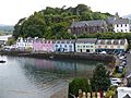
Portree was chosen as one of the "20 most beautiful villages in the UK and Ireland" by Condé Nast Traveler, and is visited by many tourists each year.
-
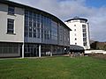
The new college buildings, Sabhal Mòr Ostaig
-
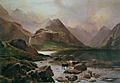
Loch Coruisk, Isle of Skye painted in 1874 by Sidney Richard Percy
-
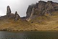
Rock pinnacles of The Storr, which feature in some of the opening scenes in the film Prometheus
-
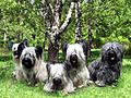
Skye Terriers
-

The Skye Flag until 2020
.jpg)


See also
 In Spanish: Isla de Skye para niños
