Posey County, Indiana facts for kids
Quick facts for kids
Posey County
|
|
|---|---|

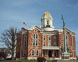
Posey County Courthouse in Mount Vernon
|
|

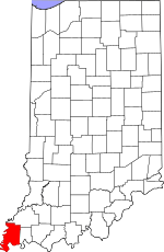
Location within the U.S. state of Indiana
|
|
 Indiana's location within the U.S. |
|
| Country | |
| State | |
| Founded | 11 November 1814 |
| Named for | Thomas Posey |
| Seat | Mount Vernon |
| Largest city | Mount Vernon |
| Area | |
| • Total | 419.32 sq mi (1,086.0 km2) |
| • Land | 409.57 sq mi (1,060.8 km2) |
| • Water | 9.75 sq mi (25.3 km2) |
| Population | |
| • Estimate
(2018)
|
25,540 |
| • Density | 62.4/sq mi (24.1/km2) |
| Time zone | UTC−6 (Central) |
| • Summer (DST) | UTC−5 (CDT) |
| Congressional district | 8th |
|
|
Posey County is the southernmost, southwesternmost, and westernmost county in the U.S. state of Indiana. Its southern border is formed by the Ohio River, and its western border by the Wabash River, a tributary to the Ohio. As of 2010, the population was 25,910. The county seat is Mount Vernon.
Posey County is part of the Evansville, IN–KY Metropolitan Statistical Area. The Ports of Indiana-Mt. Vernon, on the Ohio River, is the seventh largest inland port complex in the nation. Mechanization of dock technology has altered the number of workers at the port, but Posey County is still the seventh-largest internal port in the United States, based on the tons of materials handled. Grain from the Midwest is among the products shipped.
Contents
History
Posey County was formed on November 11, 1814 from Gibson and Warrick counties. It was named for Revolutionary War Gen. Thomas Posey, who was then serving as Governor of the Indiana Territory. Mount Vernon became the county seat in 1825.
Geography
According to the 2010 census, the county has a total area of 419.32 square miles (1,086.0 km2), of which 409.57 square miles (1,060.8 km2) (or 97.67%) is land and 9.75 square miles (25.3 km2) (or 2.33%) is water. The lowest point in the state of Indiana is located on the Ohio River in Posey County, where the waters of the Wabash River join it and flow out of Indiana and into Illinois and Kentucky.
Adjacent counties
- Gibson County - north and northeast
- Vanderburgh County - east
- Henderson County, Kentucky - southeast
- Union County, Kentucky - south
- Gallatin County, Illinois - southwest
- White County, Illinois - west and northwest
Cities and towns
Townships
- Bethel
- Black
- Center
- Harmony
- Lynn
- Marrs
- Point
- Robb
- Robinson
- Smith
Census-designated place
Other unincorporated places
- Barrett
- Blairsville
- Bufkin
- Caborn
- Dead Mans Crossing
- Erwin
- Farmersville
- Grafton
- Hepburn
- Heusler
- Hovey
- Lippe
- Marrs Center
- New Baltimore
- Oak Grove
- Oliver
- Philip Station
- Prairie
- Rapture
- Savah
- Solitude
- Springfield
- St. Philip
- St. Wendel
- Stewartsville
- Upton
- Wadesville
- Welborn Switch
- West Franklin
Transportation
Major highways
 I-64
I-64 SR 62
SR 62 SR 65
SR 65 SR 66
SR 66 SR 68
SR 68 SR 69
SR 69 SR 165
 SR 269
Railroads
- CSX Transportation
- Evansville Western Railway
River ports
- Ports of Indiana-Mt. Vernon is "the 7th largest inland port [complex] in the United States and serves as a major multi-modal hub for the region." It handles more than 4 million trip tons of cargo annually. Southwind Maritime Center is the name of a related port facility, now considered within the complex. This port facility is important to the economy of the state of Indiana as well as to Posey County. It handles shipping of grain, grain products, coal, fertilizer, cement and minerals, from a region that produces a large amount of grain. This is the largest public port within 175 miles of the confluence of the Ohio and Mississippi rivers.
Climate and weather
| Weather chart for Mount Vernon, Indiana | |||||||||||||||||||||||||||||||||||||||||||||||
|---|---|---|---|---|---|---|---|---|---|---|---|---|---|---|---|---|---|---|---|---|---|---|---|---|---|---|---|---|---|---|---|---|---|---|---|---|---|---|---|---|---|---|---|---|---|---|---|
| J | F | M | A | M | J | J | A | S | O | N | D | ||||||||||||||||||||||||||||||||||||
|
3.4
38
23
|
3.2
44
26
|
4.6
54
35
|
4.4
65
45
|
5.4
75
55
|
4
84
64
|
4.1
87
68
|
3
86
65
|
2.7
80
58
|
2.9
69
46
|
4.4
55
37
|
3.7
43
27
|
||||||||||||||||||||||||||||||||||||
| temperatures in °F precipitation totals in inches source: The Weather Channel |
|||||||||||||||||||||||||||||||||||||||||||||||
|
Metric conversion
|
|||||||||||||||||||||||||||||||||||||||||||||||
In recent years, average temperatures in Mount Vernon have ranged from a low of 23 °F (−5 °C) in January to a high of 87 °F (31 °C) in July, although a record low of −21 °F (−29 °C) was recorded in January 1912 and a record high of 109 °F (43 °C) was recorded in July 1901. Average monthly precipitation ranged from 2.65 inches (67 mm) in September to 5.38 inches (137 mm) in May.
Demographics
| Historical population | |||
|---|---|---|---|
| Census | Pop. | %± | |
| 1820 | 4,061 | — | |
| 1830 | 6,549 | 61.3% | |
| 1840 | 9,683 | 47.9% | |
| 1850 | 12,549 | 29.6% | |
| 1860 | 16,167 | 28.8% | |
| 1870 | 19,185 | 18.7% | |
| 1880 | 20,857 | 8.7% | |
| 1890 | 21,529 | 3.2% | |
| 1900 | 22,333 | 3.7% | |
| 1910 | 21,670 | −3.0% | |
| 1920 | 19,334 | −10.8% | |
| 1930 | 17,853 | −7.7% | |
| 1940 | 19,183 | 7.4% | |
| 1950 | 19,818 | 3.3% | |
| 1960 | 19,214 | −3.0% | |
| 1970 | 21,740 | 13.1% | |
| 1980 | 26,414 | 21.5% | |
| 1990 | 25,968 | −1.7% | |
| 2000 | 27,061 | 4.2% | |
| 2010 | 25,910 | −4.3% | |
| 2018 (est.) | 25,540 | −1.4% | |
| US Decennial Census 1790-1960 1900-1990 1990-2000 2010-2013 |
|||
As of the 2010 United States Census, there were 25,910 people, 10,171 households, and 7,442 families in the county. The population density was 63.3 inhabitants per square mile (24.4/km2). There were 11,207 housing units at an average density of 27.4 per square mile (10.6/km2). The racial makeup of the county was 97.2% white, 0.9% black or African American, 0.3% Asian, 0.2% American Indian, 0.4% from other races, and 1.1% from two or more races. Those of Hispanic or Latino origin made up 1.0% of the population. In terms of ancestry, 43.6% were German, 13.6% were American, 11.6% were Irish, and 11.2% were English.
Of the 10,171 households, 32.7% had children under the age of 18 living with them, 60.4% were married couples living together, 8.5% had a female householder with no husband present, 26.8% were non-families, and 23.3% of all households were made up of individuals. The average household size was 2.52 and the average family size was 2.97. The median age was 41.6 years.
The median income for a household in the county was $47,697 and the median income for a family was $68,722. Males had a median income of $55,786 versus $32,747 for females. The per capita income for the county was $26,727. About 6.0% of families and 8.3% of the population were below the poverty line, including 12.2% of those under age 18 and 8.3% of those age 65 or over.
Tourism & Recreation
- Brittlebank Park - Mount Vernon
- Harmonie State Park - New Harmony
- Hovey Lake State Fish & Wildlife Area - Mount Vernon [1]
- New Harmony Historic District [2] - New Harmony
- Sherburne Park - Mount Vernon
Education
- Mount Vernon High School - Mt. Vernon
- North Posey High School - Poseyville
See also
 In Spanish: Condado de Posey para niños

