
Powell, Wyoming facts for kids
Quick facts for kids
Powell, Wyoming
|
|
|---|---|

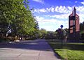
Downtown Powell, Wyoming, July 2015
|
|

Location of Powell in Park County, Wyoming.
|
|

Powell, Wyoming
Location in the United States
|
|
| Country | United States |
| State | Wyoming |
| County | Park |
| Area | |
| • Total | 4.29 sq mi (11.11 km2) |
| • Land | 4.29 sq mi (11.11 km2) |
| • Water | 0.00 sq mi (0.00 km2) |
| Elevation | 4,393 ft (1,339 m) |
| Population
(2010)
|
|
| • Total | 6,314 |
| • Estimate
(2019)
|
6,180 |
| • Density | 1,440.56/sq mi (556.27/km2) |
| Time zone | UTC−7 (Mountain (MST)) |
| • Summer (DST) | UTC−6 (MDT) |
| ZIP code |
82435
|
| Area code(s) | 307 |
| FIPS code | 56-62450 |
| GNIS feature ID | 1609143 |
Powell is a city in Park County, Wyoming, United States. The population was 6,314 at the 2010 census. Powell is an All-America City and home to Northwest College.
Contents
History
Powell was incorporated in 1909. Powell was named for John Wesley Powell, U.S. soldier, geologist and explorer. Powell post office was established January 23, 1908.
In 2013, the area was the subject of a piece of national legislation. The Powell Shooting Range Land Conveyance Act (S. 130; 113th Congress), which was passed by both the United States Senate and the United States House of Representatives, would transfer a piece of land from the Bureau of Land Management to the Powell Recreation District for continued use as a shooting range.
Geography
According to the United States Census Bureau, the city has a total area of 4.25 square miles (11.01 km2), all of it land.
Powell experiences a desert climate (Köppen BWk) with cold, dry winters and hot, slightly wetter summers.
| Climate data for Powell Field Station | |||||||||||||
|---|---|---|---|---|---|---|---|---|---|---|---|---|---|
| Month | Jan | Feb | Mar | Apr | May | Jun | Jul | Aug | Sep | Oct | Nov | Dec | Year |
| Record high °F (°C) | 58 (14) |
69 (21) |
77 (25) |
85 (29) |
93 (34) |
99 (37) |
104 (40) |
102 (39) |
95 (35) |
87 (31) |
75 (24) |
66 (19) |
104 (40) |
| Average high °F (°C) | 29.8 (−1.2) |
37.3 (2.9) |
47.6 (8.7) |
57.8 (14.3) |
67.1 (19.5) |
77.0 (25.0) |
84.2 (29.0) |
83.8 (28.8) |
71.6 (22.0) |
58.8 (14.9) |
42.4 (5.8) |
32.7 (0.4) |
57.5 (14.2) |
| Daily mean °F (°C) | 17.8 (−7.9) |
24.9 (−3.9) |
34.5 (1.4) |
43.9 (6.6) |
54.1 (12.3) |
62.7 (17.1) |
68.6 (20.3) |
67.3 (19.6) |
56.1 (13.4) |
44.1 (6.7) |
30.0 (−1.1) |
20.4 (−6.4) |
43.7 (6.5) |
| Average low °F (°C) | 5.7 (−14.6) |
12.4 (−10.9) |
21.3 (−5.9) |
30.0 (−1.1) |
41.0 (5.0) |
48.4 (9.1) |
53.0 (11.7) |
50.7 (10.4) |
40.5 (4.7) |
29.4 (−1.4) |
17.6 (−8.0) |
8.1 (−13.3) |
29.8 (−1.2) |
| Record low °F (°C) | −27 (−33) |
−33 (−36) |
−15 (−26) |
4 (−16) |
19 (−7) |
32 (0) |
32 (0) |
33 (1) |
16 (−9) |
−5 (−21) |
−18 (−28) |
−34 (−37) |
−34 (−37) |
| Average precipitation inches (mm) | 0.20 (5.1) |
0.10 (2.5) |
0.31 (7.9) |
0.50 (13) |
1.42 (36) |
1.32 (34) |
1.00 (25) |
0.52 (13) |
0.70 (18) |
0.54 (14) |
0.19 (4.8) |
0.16 (4.1) |
6.96 (177.4) |
| Source 1: NOAA (normals, 1971–2000) | |||||||||||||
| Source 2: The Weather Channel (Records) | |||||||||||||
Demographics
| Historical population | |||
|---|---|---|---|
| Census | Pop. | %± | |
| 1920 | 2,463 | — | |
| 1930 | 1,156 | −53.1% | |
| 1940 | 1,948 | 68.5% | |
| 1950 | 3,804 | 95.3% | |
| 1960 | 4,740 | 24.6% | |
| 1970 | 4,807 | 1.4% | |
| 1980 | 5,310 | 10.5% | |
| 1990 | 5,292 | −0.3% | |
| 2000 | 5,373 | 1.5% | |
| 2010 | 6,314 | 17.5% | |
| 2019 (est.) | 6,180 | −2.1% | |
| U.S. Decennial Census | |||
.jpg)

2010 census
As of the census of 2010, there were 6,314 people, 2,463 households, and 1,449 families living in the city. The population density was 1,485.6 inhabitants per square mile (573.6/km2). There were 2,627 housing units at an average density of 618.1 per square mile (238.6/km2). The racial makeup of the city was 93.7% White, 0.4% African American, 0.6% Native American, 1.2% Asian, 2.4% from other races, and 1.7% from two or more races. Hispanic or Latino of any race were 9.4% of the population.
There were 2,463 households, of which 28.4% had children under the age of 18 living with them, 45.5% were married couples living together, 9.4% had a female householder with no husband present, 3.9% had a male householder with no wife present, and 41.2% were non-families. 33.5% of all households were made up of individuals, and 13.7% had someone living alone who was 65 years of age or older. The average household size was 2.27 and the average family size was 2.93.
The median age in the city was 31.9 years. 21.2% of residents were under the age of 18; 19% were between the ages of 18 and 24; 22.8% were from 25 to 44; 20.3% were from 45 to 64; and 16.6% were 65 years of age or older. The gender makeup of the city was 48.5% male and 51.5% female.
Economy
Powell was originally established as a cattle ranching community. Oil reserves were found in the late-19th century, prompting the CB&Q Railroad (later BNSF), to extend a line into Powell. In the early 20th century, the Homestead Acts and the Shoshone Project contributed greatly to agricultural development in the Bighorn Basin. Mineral extraction and agriculture are still the key industries of Powell, with sugar beets, barley, and pinto beans being the most commonly grown cash crops. Beef production remains an important facet of the Powell economy, as well. When the local department store in Powell closed, the community raised $400,000 and established the Powell Mercantile, a community-owned store.
Education
Powell has a public library, a branch of the Park County Library System.
Public K–12 education is administered by Park County School District No. 1, and includes 4 K–5 elementary schools (one of which is located in Clark, WY), Powell Middle School, Powell High School, and the Shoshone Learning Center, an alternative high school. Northwest College, a public two-year residential college, is located in the Northern portion of Powell. Several 4-year degrees are available at Northwest through the University of Wyoming's extended campus.
Notable people
- Chris Cooley (born 1982), American football player
- Darren Dalton (born 1965), film actor (The Outsiders)
- W. Edwards Deming (1900–1993), worked to reconstruct the Japanese economy after World War II
- Dennis Havig (born 1949), American football player
Images for kids
-
Northwest College

See also
 In Spanish: Powell (Wyoming) para niños
