
Prêles facts for kids
Quick facts for kids
Prêles
|
||
|---|---|---|
|
||
| Country | Switzerland | |
| Canton | Berne | |
| District | Jura bernois | |
| Area | ||
| • Total | 6.98 km2 (2.69 sq mi) | |
| Elevation | 822 m (2,697 ft) | |
| Population
(Dec 2011)
|
||
| • Total | 908 | |
| • Density | 130.09/km2 (336.9/sq mi) | |
| Postal code |
2515
|
|
| Surrounded by | Diesse, La Neuveville, Lamboing, Ligerz, Lignières (NE), Nods, Twann | |

Prêles (German name: Prägelz) is a former municipality in the Jura bernois administrative district in the canton of Bern in Switzerland, located in the French-speaking Bernese Jura (Jura Bernois).
The proposed merger of the municipalities of Diesse, Lamboing, Nods and Prêles into the new municipality of Le Plateau de Diesse was rejected by voters. However, on 1 January 2014 the former municipalities of Prêles, Diesse and Lamboing merged into the new municipality of Plateau de Diesse.
Contents
History
Prêles is first mentioned in 1179 as Prales though this document is believed to be a 12th-century forgery. In 1185 it was mentioned as Preles and it used to be known by its German name Prägelz.
Beginning in the 12th century the noble de Perls family first appears in records. The family existed for several centuries before vanishing from records in the 15th century. Throughout its history the village was part of the Herrschaft of Tessenberg (Diesse). The major landowners in the village included the collegiate church of Saint-Imier and Erlach Abbey. It was part of the parish of Diesse and accepted the Protestant Reformation along with the rest of the parish between 1530 and 1554.
After the 1798 French invasion, Prêles became part of the French Département of Mont-Terrible. Three years later, in 1800 it became part of the Département of Haut-Rhin. After Napoleon's defeat and the Congress of Vienna, Prêles was assigned to the Canton of Bern in 1815. Initially it was part of the District of Erlach but in 1846 it became part of the La Neuveville District.
The construction of a cable railway between Ligerz and Prêles in 1912 turned it into a minor tourist destination. Until the 1950s agriculture was the most important industry in the village. Today many residents commute to jobs in Biel or La Neuveville. In the past decades a number of new houses were built for the growing commuter population.
Geography

Before the merger, Prêles had a total area of 7.0 km2 (2.7 sq mi). As of 2012, a total of 4.37 km2 (1.69 sq mi) or 62.8% is used for agricultural purposes, while 1.89 km2 (0.73 sq mi) or 27.2% is forested. Of the rest of the land, 0.73 km2 (0.28 sq mi) or 10.5% is settled (buildings or roads) and 0.02 km2 (4.9 acres) or 0.3% is unproductive land.
During the same year, housing and buildings made up 6.0% and transportation infrastructure made up 2.7%. while parks, green belts and sports fields made up 1.6%. Out of the forested land, 23.1% of the total land area is heavily forested and 4.0% is covered with orchards or small clusters of trees. Of the agricultural land, 37.4% is used for growing crops and 23.1% is pastures and 1.7% is used for alpine pastures.
The former municipality is located on the Plateau de Diesse. It consists of the village of Prêles and the hamlet of Châtillon.
On 31 December 2009 District de la Neuveville, the municipality's former district, was dissolved. On the following day, 1 January 2010, it joined the newly created Arrondissement administratif Jura bernois.
Images for kids
-
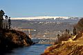
The Hagneck canal of the Aare river. The village Prêles is visible on the hill above the river and below the Chasseral peak.

See also
 In Spanish: Prêles para niños
