
Preonzo facts for kids
Quick facts for kids
Preonzo
|
||
|---|---|---|
|
||
| Country | Switzerland | |
| Canton | Ticino | |
| District | Bellinzona | |
| Area | ||
| • Total | 16.44 km2 (6.35 sq mi) | |
| Elevation | 250 m (820 ft) | |
| Population
(Dec 2020 )
|
||
| • Total | 614 | |
| • Density | 37.35/km2 (96.73/sq mi) | |
| Postal code |
6523
|
|
| Surrounded by | Claro, Cresciano, Cugnasco, Gnosca, Gorduno, Lavertezzo, Lodrino, Moleno, Monte Carasso, Vogorno | |

Preonzo is a former municipality in the district of Bellinzona in the canton of Ticino in Switzerland.
On 2 April 2017 the former municipalities of Camorino, Claro, Giubiasco, Gnosca, Gorduno, Moleno, Monte Carasso, Pianezzo, Sant'Antonio and Sementina merged into the municipality of Bellinzona.
Contents
History

Preonzo is first mentioned in 1335 as Prevonzo. In the 14th Century, Moleno and Preonzo formed a settlement. In 1335 it became a municipality in the County of Bellinzona. During the first conquest of the Ticino in 1403-22, it was ruled by the cantons of Uri and Obwalden. They granted the villages its statutes and customary rights (Statuti, ordini), although, in contrast to Moleno, it was not incorporated in the Levantine.
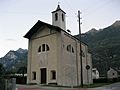
The parish church of SS Simone e Giuda was built in 1459. In the 17th century it was rebuilt and then renovated in 1963-66 and 1996-97. It broke away from the Church of S. Vittore in Moleno in 1545. Together with Gnosca and Moleno it was one of the three churches that used the Ambrosian Rite in the County of Bellinzona.
Traditionally, the village economy was based mostly on alpine pasturage and agriculture. However, by 2005, only 13% of jobs were in agriculture, while 56% were in manufacturing. More than three-quarters of workers commuted to Biasca and Bellinzona.
Geography


Preonzo has an area, as of 1997[update], of 16.44 square kilometers (6.35 sq mi). Of this area, 1.22 km2 (0.47 sq mi) or 7.4% is used for agricultural purposes, while 9.93 km2 (3.83 sq mi) or 60.4% is forested. Of the rest of the land, 0.55 km2 (0.21 sq mi) or 3.3% is settled (buildings or roads), 0.39 km2 (0.15 sq mi) or 2.4% is either rivers or lakes and 4.11 km2 (1.59 sq mi) or 25.0% is unproductive land.
Of the built up area, housing and buildings made up 1.0% and transportation infrastructure made up 1.5%. Out of the forested land, 44.8% of the total land area is heavily forested, while 15.1% is covered in small trees and shrubbery. Of the agricultural land, 5.7% is used for growing crops. All the water in the municipality is flowing water. Of the unproductive areas, 12.8% is unproductive vegetation and 12.2% is too rocky for vegetation.
The municipality is located in the Bellinzona district, on the right bank of the Ticino river between Bellinzona and Biasca.
Images for kids
-
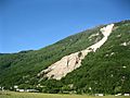
Results of the 17 May 2012 rockslide
-
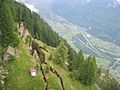
Fractures from the 6 June 2012 rockslide
-
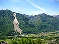
Preonzo village at the foot of the mountains
-
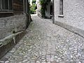
Paved street in the center of Preonzo
-
Church of the Madonna, in Preonzo


See also
 In Spanish: Preonzo para niños
