
Prince Edward Islands facts for kids

Map of Prince Edward Islands
|
|

Orthographic projection centred on the Prince Edward Islands
|
|
| Geography | |
|---|---|
| Location | Indian Ocean |
| Coordinates | 46°53′19″S 37°44′08″E / 46.888739°S 37.735658°E |
| Area | 335 km2 (129 sq mi) |
| Highest elevation | 1,242 m (4,075 ft) |
| Highest point | Mascarin Peak |
| Administration | |
| Demographics | |
| Population | 0 (Uninhabited – Permanent) 50 (Research Staff – Non-Permanent) |
|
Designations
|
|
| Designated: | 24 January 1997 |
|---|---|
| Reference #: | 1688 |
The Prince Edward Islands are two small islands in the sub-antarctic Indian Ocean that are part of South Africa. The islands are named Marion Island (named after Marc-Joseph Marion du Fresne) and Prince Edward Island (named after Prince Edward, Duke of Kent and Strathearn).
The islands in the group have been declared Special Nature Reserves under the South African Environmental Management: Protected Areas Act, No. 57 of 2003, and activities on the islands are therefore restricted to research and conservation management. Further protection was granted when the area was declared a marine protected area in 2013. The only human inhabitants of the islands are the staff of a meteorological and biological research station run by the South African National Antarctic Programme on Marion Island.
Images for kids
-
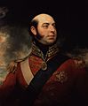
Prince Edward, after whom the islands are named
-
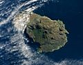
Prince Edward Island as seen from outer space on 5 May 2009.
-
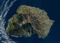
Marion Island as seen from outer space on 5 May 2009
-
Logo of Marion Island
-
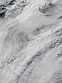
Cloud patterns over the Prince Edward Islands


See also
 In Spanish: Islas del Príncipe Eduardo para niños
