
Providence, Rhode Island facts for kids
Quick facts for kids
Providence, Rhode Island
|
|||
|---|---|---|---|
| City of Providence | |||
|
From top, left to right: Downtown Providence skyline and the Providence River, Weybosset Street and the Providence Performing Arts Center, University Hall at Brown University, the Crawford Street Bridge and Financial District, DePasquale Square in Federal Hill, Rhode Island State House
|
|||
|
|||
| Nickname(s):
The Creative Capital, the Renaissance City, the Divine City, PVD, Prov
|
|||
| Motto(s):
"What Cheer?"
|
|||
| Country | |||
| State | |||
| County | Providence | ||
| Region | New England | ||
| Settled | 1636 | ||
| Incorporated (town) | June 1636 | ||
| Incorporated (city) | November 5, 1832 | ||
| Founded by | Roger Williams | ||
| Named for | Divine providence | ||
| Government | |||
| • Type | Mayor-Council | ||
| Area | |||
| • State capital city | 20.58 sq mi (53.31 km2) | ||
| • Land | 18.41 sq mi (47.67 km2) | ||
| • Water | 2.18 sq mi (5.64 km2) | ||
| Elevation | 75 ft (23 m) | ||
| Population
(2020)
|
|||
| • State capital city | 190,934 | ||
| • Rank | US: 134th | ||
| • Density | 10,371.21/sq mi (4,005.32/km2) | ||
| • Urban | 1,190,956 (US: 39th) | ||
| • Metro | 1,604,291 (US: 38th) | ||
| Time zone | UTC−5 (Eastern Time Zone) | ||
| • Summer (DST) | UTC−4 (EDT) | ||
| ZIP Codes |
02901–02912, 02918-02919, 02940
|
||
| Area code | 401 | ||
| FIPS code | 44-59000 | ||
| GNIS feature ID | 1219851 | ||
| Major highways | |||
| Commuter Rail | |||

.jpg)

.jpg)


Providence is the capital and most populous city of the U.S. state of Rhode Island. One of the oldest cities in the United States, it was founded in 1636 by Roger Williams, a Reformed Baptist theologian and religious exile from the Massachusetts Bay Colony. He named the area in honor of "God's merciful Providence" which he believed was responsible for revealing such a haven for him and his followers. The city is situated at the mouth of the Providence River at the head of Narragansett Bay.
Providence was one of the first cities in the country to industrialize and became noted for its textile manufacturing and subsequent machine tool, jewelry, and silverware industries. Today, the city of Providence is home to eight hospitals and eight institutions of higher learning which have shifted the city's economy into service industries, though it still retains some manufacturing activity.
As of the 2020 United States Census, Providence has a population of 190,934, making it the third-most-populous city in New England after Boston and Worcester, Massachusetts.
Contents
History

Settlement
The area that is now Providence was first settled in June 1636 by Roger Williams and was one of the original Thirteen Colonies of the United States. Williams and his company felt compelled to withdraw from Massachusetts Bay Colony. Providence quickly became a refuge for persecuted religious dissenters, as Williams himself had been exiled from Massachusetts.
Revolution
Providence residents were among the first Patriots to spill blood in the leadup to the American Revolution during the Gaspée Affair of 1772. Rhode Island was the first of the thirteen colonies to renounce its allegiance to the British Crown on May 4, 1776. It was also the last of the thirteen colonies to ratify the United States Constitution on May 29, 1790, once assurances were made that a Bill of Rights would become part of the Constitution.

Incorporation as a city
Following the war, Providence was the country's ninth-largest city with 7,614 people. The economy shifted from maritime endeavors to manufacturing, in particular machinery, tools, silverware, jewelry, and textiles. By the start of the 20th century, Providence boasted some of the largest manufacturing plants in the country, including Brown & Sharpe, Nicholson File, and Gorham Silverware.

City Government
Providence residents ratified a city charter in 1831 as the population passed 17,000. From its incorporation as a city in 1832 until 1878, the seat of city government was located in the Market House, located in Market Square, which was the geographic and social center of the city. The city offices quickly outgrew this building, and the City Council resolved to create a permanent municipal building in 1845. The city offices moved into the City Hall in 1878.
Civil War
During the Civil War, local politics split over slavery as many had ties to Southern cotton. Despite ambivalence concerning the war, the number of military volunteers routinely exceeded quota, and the city's manufacturing proved invaluable to the Union.
20th Century
By the early 1900s, Providence was one of the wealthiest cities in the United States. Immigrant labor powered one of the nation's largest industrial manufacturing centers. Providence was a major manufacturer of industrial products from steam engines to precision tools to silverware, screws, and textiles. Giant companies such as Brown & Sharpe, the Corliss Steam Engine Company, Babcock & Wilcox, the Grinnell Corporation, the Gorham Manufacturing Company, Nicholson File, and the Fruit of the Loom textile company were based in or near Providence.

From 1975 until 1982, $606 million of local and national Community Development funds were invested throughout the city. In the 1990s, the city pushed for revitalization, ultimately resulting in uncovering the rivers (which had been covered by paved bridges), relocating a large section of railroad underground, creating Waterplace Park and river walks along the river's banks, and constructing the Fleet Skating Rink (now the Alex and Ani City Center) downtown and the 1.4 million ft² Providence Place Mall.
21st Century
Despite new investment, poverty remains an entrenched problem as it does in most post-industrial New England cities. Approximately 27.9 percent of the city population is living below the poverty line. Recent increases in real estate values further exacerbate problems for those at marginal income levels, as Providence had the highest rise in median housing price of any city in the United States from 2004 to 2005.
The city is recovering from the real-estate slump, with a proposed residential skyscraper project called Hope Point Towers announced in mid-November, 2016.
Geography
.jpg)
The Providence city limits enclose a small geographical region with a total area of 20.5 square miles (53 km2); 18.5 square miles (48 km2) of it is land and the remaining 2.1 square miles (5.4 km2) is water (roughly 10%). Providence is located at the head of Narragansett Bay, with the Providence River running into the bay through the center of the city, formed by the confluence of the Moshassuck and Woonasquatucket Rivers. The Waterplace Park amphitheater and riverwalks line the river's banks through downtown.
Providence is one of many cities claimed to be founded on seven hills like Rome. The more prominent hills are: Constitution Hill (near downtown), College Hill (east of the Providence River), and Federal Hill (west of downtown and containing New England's largest Italian district outside of Massachusetts). The other four are: Tockwotten Hill at Fox Point, Smith Hill (where the State House is located), Christian Hill at Hoyle Square (junction of Cranston and Westminster Streets), and Weybosset Hill at the lower end of Weybosset Street, which was leveled in the early 1880s.
Neighborhoods


Providence has 25 official neighborhoods, though these neighborhoods are often grouped together and referred to collectively:
- The East Side is a region comprising the neighborhoods of Blackstone, Hope (aka Summit), Mount Hope, College Hill, Wayland, and Fox Point.
- The Jewelry District describes the area enclosed by I-95, the old I-195, and the Providence River. The city has made efforts to rename this area the Knowledge District to reflect the area's newly developing life sciences and technology-based economy.
- The North End is formed by the combination of the neighborhoods of Charles, Wanskuck, Smith Hill, Elmhurst, and Mount Pleasant.
- The South Side (or South Providence) consists of the neighborhoods of Elmwood, Lower South Providence, Upper South Providence, and the West End.
- West Broadway is an officially recognized neighborhood with its own association. It overlaps with the southern half of Federal Hill and the northern part of the West End.
- The West Side is a vague term sometimes used to mean the Federal Hill, Olneyville, Hartford, and Silver Lake.
Cityscape


The city of Providence is geographically very compact, characteristic of eastern seaboard cities that developed prior to use of the automobile. It is among the most densely populated cities in the country. For this reason, Providence has the eighth-highest percentage of pedestrian commuters. The street layout is irregular; more than one thousand streets (a great number for the city's size) run haphazardly, connecting and radiating from traditionally bustling places such as Market Square.
Downtown Providence has numerous 19th-century mercantile buildings in the Federal and Victorian architectural styles, as well as several post-modern and modernist buildings located throughout the area. In particular, a fairly clear spatial separation appears between the areas of pre-1980s development and post-1980s development. West Exchange Street and Exchange Terrace serve as rough boundaries between the two.
The newer area, sometimes called "Capitol Center", includes Providence Place Mall (1999), the Omni Providence Hotel (1993) and The Residences Providence (2007), GTECH Corporation (2006), Waterplace condominiums (2007), and Waterplace Park (1994). The area tends toward newer development, since much of it is land reclaimed in the 1970s from a mass of railroad tracks referred to colloquially as the "Chinese Wall". This part of Downtown is characterized by open spaces, wide roads, and landscaping.
The historic part of downtown has many streetscapes that look as they did eighty years ago. Many of the state's tallest buildings are found here. The largest structure at 426 feet (130 m) is the art deco styled 111 Westminster Street (formerly Industrial Trust Tower). By contrast, nearby to it is the second tallest One Financial Plaza, designed in modern taut-skin cladding, constructed a half-century later. In between the two is 50 Kennedy Plaza. The Textron Tower is also a core building to the modest Providence skyline. Downtown is also the home of the Providence Biltmore and Westminster Arcade, the oldest enclosed shopping mall in the U.S., built in 1828.
The city's southern waterfront, away from the downtown core, is the location of many oil tanks, a docking station for a ferry boat, a non-profit sailing center, bars, clubs, and power plants. The Russian Submarine Museum was located here until 2008, when the submarine sank in a storm and was declared a loss. The Fox Point Hurricane Barrier is also found here, built to protect Providence from storm surge like that which it endured in the 1938 New England Hurricane and again in 1954 from Hurricane Carol.
The majority of the cityscape comprises abandoned and revitalized industrial mills, double- and triple-decker housing (though row houses are rare, found so commonly in other Northeast cities), a small number of high-rise buildings (predominantly for housing the elderly), and single family homes. Interstate 95 serves as a physical barrier between the city's commercial core and neighborhoods such as Federal Hill and the West End.
Climate

Providence has a humid continental (Köppen Cfa or Dfa) with warm summers, cold winters, and high humidity year-round. The USDA places the city in Hardiness zone 6b, with the suburbs falling in zones 6a – 7b. The influence of the Atlantic Ocean keeps Providence, and the rest of the state of Rhode Island, warmer than many inland locales in New England. January is the coldest month with a daily mean of 29.2 °F (−1.6 °C), and low temperatures dropping to 10 °F (−12 °C) or lower an average of 11 days per winter, while July is the warmest month with a daily mean of 73.5 °F (23.1 °C), and highs rising to 90 °F (32 °C) or higher an average of 10 days per summer. Extremes range from −17 °F (−27 °C) on February 9, 1934 to 104 °F (40 °C) on August 2, 1975; the record cold daily maximum is 1 °F (−17 °C) on February 5, 1918, while the record warm daily minimum is 80 °F (27 °C) on June 6, 1925. Temperature readings of 0 °F (−18 °C) or lower are uncommon in Providence, and generally occur once every several years. The year which had the most days with a temperature reading of zero degrees or lower was 2015 with eight days total; one day in January and seven days in February. Conversely, temperature readings of 100 °F (38 °C) or higher are even rarer, and the year with the most days in this category was 1944 with three days, all of which were in August.
As with the rest of the northeastern seaboard, Providence receives ample precipitation year-round. Monthly precipitation ranges from a high of 4.43 inches (112.5 mm) in March to a low of 3.17 inches (80.5 mm) in July. In general, precipitation levels are slightly lesser in the summer months than the winter months, when powerful storms known as Nor'easters can cause significant snowfall and blizzard conditions. Although hurricanes are not frequent in coastal New England, Providence's location at the head of Narragansett Bay makes it vulnerable to them.
| Climate data for Providence, Rhode Island (T. F. Green Airport), 1981–2010 normals, extremes 1904–present | |||||||||||||
|---|---|---|---|---|---|---|---|---|---|---|---|---|---|
| Month | Jan | Feb | Mar | Apr | May | Jun | Jul | Aug | Sep | Oct | Nov | Dec | Year |
| Record high °F (°C) | 69 (21) |
72 (22) |
90 (32) |
98 (37) |
96 (36) |
98 (37) |
102 (39) |
104 (40) |
100 (38) |
88 (31) |
81 (27) |
77 (25) |
104 (40) |
| Mean maximum °F (°C) | 57.2 (14.0) |
58.3 (14.6) |
68.4 (20.2) |
80.3 (26.8) |
86.2 (30.1) |
91.3 (32.9) |
94.5 (34.7) |
92.3 (33.5) |
87.0 (30.6) |
78.1 (25.6) |
70.0 (21.1) |
60.8 (16.0) |
96.2 (35.7) |
| Average high °F (°C) | 37.4 (3.0) |
40.3 (4.6) |
47.8 (8.8) |
58.6 (14.8) |
68.4 (20.2) |
77.5 (25.3) |
82.8 (28.2) |
81.4 (27.4) |
74.2 (23.4) |
63.3 (17.4) |
53.2 (11.8) |
42.3 (5.7) |
60.6 (15.9) |
| Average low °F (°C) | 21.0 (−6.1) |
23.6 (−4.7) |
30.0 (−1.1) |
39.6 (4.2) |
48.6 (9.2) |
58.4 (14.7) |
64.2 (17.9) |
63.2 (17.3) |
55.3 (12.9) |
43.9 (6.6) |
35.7 (2.1) |
26.3 (−3.2) |
42.5 (5.8) |
| Mean minimum °F (°C) | 2.9 (−16.2) |
7.7 (−13.5) |
14.7 (−9.6) |
28.8 (−1.8) |
36.9 (2.7) |
47.1 (8.4) |
55.0 (12.8) |
52.4 (11.3) |
42.2 (5.7) |
31.2 (−0.4) |
21.7 (−5.7) |
10.4 (−12.0) |
0.9 (−17.3) |
| Record low °F (°C) | −13 (−25) |
−17 (−27) |
1 (−17) |
11 (−12) |
29 (−2) |
39 (4) |
48 (9) |
40 (4) |
32 (0) |
20 (−7) |
6 (−14) |
−12 (−24) |
−17 (−27) |
| Average precipitation inches (mm) | 3.86 (98) |
3.29 (84) |
5.01 (127) |
4.36 (111) |
3.55 (90) |
3.64 (92) |
3.29 (84) |
3.60 (91) |
3.92 (100) |
3.93 (100) |
4.51 (115) |
4.22 (107) |
47.18 (1,198) |
| Average snowfall inches (cm) | 9.0 (23) |
8.5 (22) |
5.5 (14) |
0.6 (1.5) |
0 (0) |
0 (0) |
0 (0) |
0 (0) |
0 (0) |
0 (0) |
1.5 (3.8) |
8.7 (22) |
33.8 (86) |
| Average precipitation days (≥ 0.01 in) | 10.9 | 9.7 | 11.9 | 11.3 | 12.0 | 10.9 | 9.4 | 9.0 | 8.7 | 9.4 | 10.1 | 11.6 | 124.9 |
| Average snowy days (≥ 0.1 in) | 5.7 | 4.6 | 3.5 | 0.4 | 0 | 0 | 0 | 0 | 0 | 0 | 0.6 | 3.9 | 18.7 |
| Average relative humidity (%) | 63.9 | 63.0 | 62.9 | 61.4 | 66.6 | 70.1 | 71.0 | 72.5 | 73.0 | 70.2 | 68.9 | 67.0 | 67.5 |
| Mean monthly sunshine hours | 171.7 | 172.6 | 215.6 | 225.1 | 254.9 | 274.1 | 290.6 | 262.8 | 233.0 | 208.7 | 148.0 | 148.6 | 2,605.7 |
| Percent possible sunshine | 58 | 58 | 58 | 56 | 57 | 60 | 63 | 61 | 62 | 61 | 50 | 52 | 58 |
| Source: NOAA (relative humidity and sun 1961–1990), The Weather Channel | |||||||||||||
Demographics
| Historical population | ||
|---|---|---|
| Year | Pop. | ±% |
| 1708 | 1,446 | — |
| 1730 | 3,916 | +170.8% |
| 1748 | 3,452 | −11.8% |
| 1755 | 3,159 | −8.5% |
| 1774 | 4,321 | +36.8% |
| 1782 | 4,310 | −0.3% |
| 1790 | 6,380 | +48.0% |
| 1800 | 7,614 | +19.3% |
| 1810 | 10,070 | +32.3% |
| 1820 | 11,767 | +16.9% |
| 1830 | 16,833 | +43.1% |
| 1840 | 23,171 | +37.7% |
| 1850 | 41,513 | +79.2% |
| 1860 | 50,666 | +22.0% |
| 1870 | 68,904 | +36.0% |
| 1880 | 104,857 | +52.2% |
| 1890 | 132,146 | +26.0% |
| 1900 | 175,597 | +32.9% |
| 1910 | 224,326 | +27.8% |
| 1920 | 237,595 | +5.9% |
| 1930 | 252,981 | +6.5% |
| 1940 | 253,504 | +0.2% |
| 1950 | 248,674 | −1.9% |
| 1960 | 207,498 | −16.6% |
| 1970 | 179,213 | −13.6% |
| 1980 | 156,804 | −12.5% |
| 1990 | 160,728 | +2.5% |
| 2000 | 173,618 | +8.0% |
| 2010 | 178,042 | +2.5% |
| 2020 | 190,934 | +7.2% |
| Source: Largest Cities and Other Urban Places in the United States 1790 to 1990 2019 Estimate 1708 to 1782 |
||
| Demographic profile | 2020 | 2010 | 1990 | 1970 | 1950 |
|---|---|---|---|---|---|
| White | 53.1% | 49.8% | 69.9% | 90.0% | 96.5% |
| —Non-Hispanic | 33.8% | 37.6% | 64.5% | 89.5% | N/A |
| Black or African American | 16.1% | 16.0% | 14.8% | 8.9% | 3.3% |
| Hispanic or Latino (of any race) | 43.5% | 38.1% | 15.5% | 0.8% | N/A |
| Asian | 5.6% | 6.4% | 5.9% | 0.5% | 0.1% |
As of the 2000 United States census, Providence's population consisted of 173,618 people, 162,389 households, and 35,859 families. The population density was 9,401.7 inhabitants per square mile (3,629.4/km2), characteristic of other small cities in New England such as New Haven, Connecticut; Springfield, Massachusetts; and Hartford, Connecticut. The city's population peaked in the 1940s, just prior to the nationwide period of rapid suburbanization.
Providence has a racially and ethnically diverse population. In 2020, white Americans formed 53.1% of the population, including a sizable white Hispanic community. Non-Hispanic whites were 33.8% of the total population, down from 89.5% in 1970. Providence has had a substantial Italian American population since the start of the 20th century, with 14% of the population claiming Italian ancestry. Italian influence manifests itself in Providence's 'Little Italy' in Federal Hill. Irish immigrants have also had considerable influence on the city's history, with 8% of residents claiming Irish heritage. The percentages of people claiming Irish and Italian ancestry, though high, has gone down considerably from historical highs, and is much lower than the percentages of these groups in Rhode Island as a whole. The city also has a sizable Jewish community, estimated at 10,500 in 2012, or roughly 5% of the city's population.
.png)
In 2020, people of Hispanic or Latino origin composed 43.5% of the city's population. They formed a majority of city public school students as of 2007. The majority of Hispanics in Providence are of Dominican descent. Constituting roughly half of the city's Hispanic population, Providence's Dominican community is one of the largest in the United States. Other Hispanic groups present in sizable numbers include Puerto Ricans, Guatemalans, and Colombians. Hispanics are widespread in significant numbers in most of Providence, but most concentrated in the neighborhoods of Elmwood, the West End, and Upper and Lower South Providence.
African Americans constitute 16.1% of the city's population, with their greatest concentrations found in Mount Hope and the Upper and Lower South Providence neighborhoods. Providence has small Liberian and Haitian communities in the city. Liberians compose 0.4% of the population; the city is home to one of the largest Liberian immigrant populations in the country. Asian-Americans constitute 5.6% of Providence's population. The largest Asian groups are Cambodians (1.7%), Chinese (1.1%), Indian Americans (0.7%), Laotians (0.6%), and Koreans (0.6%). Another 6% of the city has multiracial ancestry. American Indians and Pacific Islanders make up the remaining 0.9%.
Providence has a considerable community of immigrants from various Portuguese-speaking countries, especially Portugal, Brazil, and Cape Verde. These residents are concentrated in the Washington Park and Fox Point neighborhoods. Portuguese is the city's third-largest European ethnicity, after Italian and Irish. At 4% of the population; Cape Verdeans compose 2% of the city's population.
The Providence metropolitan area includes Providence, Fall River, Massachusetts, and Warwick, and is estimated to have a population of 1,622,520. In 2006, this area was officially added to the Boston Combined Statistical Area (CSA), the sixth-largest CSA in the country. In recent years, Providence has experienced a sizable growth in its under-18 population. The median age of the city was 28 years, while the largest age cohort is 20- to 24-year-olds, as of 2000.
The per capita income as of the 2000 census was $15,525, which is well below both the state average of $29,113 and the national average of $21,587. The median income for a household was $26,867, and the median income for a family in Providence was $32,058,. The city has one of the highest rates of poverty in the nation with 29.1% of the population and 23.9% of families living below the poverty line. Of residents in poverty, the largest concentrations are found in the city's Olneyville, and Upper and Lower South Providence areas. Poverty has affected children at a disproportionately higher rate, with 40.1% of those under the age of 18 living below the poverty line. These residents are concentrated west of Downtown in the neighborhoods of Hartford, Federal Hill, and Olneyville.
Culture

Much of Providence culture is synonymous with Rhode Island culture. Like the state, the city has a non-rhotic accent that can be heard on local media. Providence also shares Rhode Island's affinity for coffee, as the former has the most coffee/doughnut shops per capita of any city in the country. Providence, like many other towns, is also reputed to have the highest number of restaurants per capita, many of which founded and/or staffed by its own Johnson & Wales University graduates.

Providence has several ethnic neighborhoods, notably Federal Hill and the North End (Italian), Fox Point (Portuguese), West End (mainly Central American and Asians), and Smith Hill (Irish with miscellaneous enclaves of other groups). There are also many dedicated community organizations and arts associations located in the city.
The city gained the reputation as one of the most active and growing gay communities in the Northeast; the rate of reported gay and lesbian relationships is 75% higher than the national average and Providence has been named among the "Best Lesbian Places to Live".

During the summer months, the city regularly hosts WaterFire, an environmental art installation that consists of about 100 bonfires that blaze just above the surface of the three rivers that pass through the middle of downtown Providence. There are multiple Waterfire events that are accompanied by various pieces of classical and world music. The public art displays, most notably sculptures, change on a regular basis.
The city is also the home of the Tony Award-winning theater group Trinity Repertory Company, the Providence Black Repertory Company, and the Rhode Island Philharmonic Orchestra, as well as groups like The American Band, once associated with noted American composer D. W. Reeves. Providence is also the home of several performing arts centers such as the Veterans Memorial Auditorium, the Providence Performing Arts Center, and the Providence Festival Ballet. The city's underground music scene, centered on artist-run spaces such as the now-defunct Fort Thunder, is known in underground music circles. Providence is also home to the Providence Improv Guild, an improvisational theatre that has weekly performances and offers improv and sketch comedy classes.
Sites of interest

Providence is home to a 1,200-acre (4.9 km2) park system, notably Waterplace Park and Riverwalk, Roger Williams Park, Roger Williams National Memorial, and Prospect Terrace Park, the latter featuring expansive views of the downtown area as well as a 15-foot tall granite statue of Roger Williams gazing over the city. As one of the first cities in the country, Providence contains many historic buildings, while the East Side neighborhood in particular includes the largest contiguous area of buildings listed on the National Register of Historic Places in the U.S., with many pre-revolutionary houses. The East Side is also home to the First Baptist Church in America, which was founded by Williams in 1638, as well as the Old State House which served as the state's capitol from 1762 to 1904. Nearby is Roger Williams National Memorial. The dome of the State House is the fourth-largest self-supporting marble dome in the world and the second-largest marble dome after St. Peter's Basilica in Rome, as well as the Westminster Arcade, which is the oldest enclosed shopping center in the U.S.

The main art museum is the Rhode Island School of Design Museum, which has the 20th-largest collection in the country. The city is home to the Providence Athenæum, the fourth oldest library in the country, in addition to the Providence Public Library and the nine branches of the Providence Community Library. Edgar Allan Poe met and courted a love interest here named Sarah Helen Whitman on one of his many visits to Providence. Poe was a regular fixture here, as was H. P. Lovecraft (who was born in Providence), both influential writers of gothic literature.
The Alex and Ani City Center (formerly the Bank of America Skating Center, and Fleet Skating Center) is located near Kennedy Plaza in the downtown district, connected by pedestrian tunnel to Waterplace Park, a cobblestone and concrete park below street traffic that abuts Providence's three rivers.
The southern part of the city is home to the famous roadside attraction Nibbles Woodaway (also known as the "Big Blue Bug"), the world's largest termite. Roger Williams Park contains a zoo, a botanical center, and the Museum of Natural History and Planetarium.
Another well-known site is the Providence Biltmore Hotel located downtown near Kennedy Plaza, a historic location built in 1922. The hotel is still a very popular site for travelers going in and out of the state every day. The Biltmore closed in 1974. It was added to the National Register of Historic Places in 1977, and it reopened in 1979.
Sports

The city is home to the American Hockey League team Providence Bruins, which plays at the Dunkin' Donuts Center (formerly the Providence Civic Center). From 1926 to 1972, the AHL's Providence Reds (renamed the Rhode Island Reds in their last years) played at the Rhode Island Auditorium. In 1972, the team relocated to the Providence Civic Center, where they played until moving to Binghamton, New York, in 1977.
The city has two rugby teams, the Rugby Union team Providence Rugby Football Club, and the Semi-Professional Rugby League team The Rhode Island Rebellion, which play at Classical High School. In 2013 the Rebellion finished the USA Rugby League (USARL) regular season in third place. Their playoff run took them to the USARL Semi-Finals, the first time the Rebellion made the playoffs in its short three-year history.
The NFL's New England Patriots and MLS's New England Revolution play in Foxborough, Massachusetts, which is situated halfway between Providence and Boston. Providence was formerly home to two major league franchises: the NFL's Providence Steam Roller in the 1920s and 1930s, and the NBA's Providence Steamrollers in the 1940s. The Rhode Island Auditorium also hosted won 29 of the 49 boxing fights of Rocky Marciano.
The city's defunct baseball team, the Providence Grays, competed in the National League from 1879 through 1885. The team defeated the New York Metropolitans in baseball's first successful "world championship series" in 1884. In 1914, after the Boston Red Sox purchased Babe Ruth from the then-minor league Baltimore Orioles, the team prepared Ruth for the major leagues by sending him to finish the season playing for a minor league team in Providence that was also known as the Grays. Today, professional baseball is offered by the Pawtucket Red Sox, the AAA affiliate of the Boston Red Sox, which plays in nearby Pawtucket. Most baseball fans—along with the local media—tend to follow the Boston Red Sox.
Major colleges and universities fielding NCAA Division I athletic teams are Brown University and Providence College. The latter is a member of the Big East Conference. Much local hype is associated with games between these two schools or the University of Rhode Island.
Providence has also hosted the alternative sports event Gravity Games from 1999 to 2001, and was also the first host of ESPN's X Games, known in its first edition as the Extreme Games, in 1995. Providence has its own roller derby league. Formed in 2004, it currently has four teams: the Providence Mob Squad, the Sakonnet River Roller Rats, the Old Money Honeys, and the Rhode Island Riveters. Providence is also home to the headquarters of the American Athletic Conference (The American).
Sister cities
As of 2008[update], Providence had three official sister cities:
 Praia (1994)
 Florence (2002)
 Santo Domingo (2004)
Economy
Around 1830, Providence had manufacturing industries in metals, machinery, textiles, jewelry, and silverware. Manufacturing has declined since, but the city is still one of the largest centers for jewelry and silverware design and manufacturing. Services also make up a large portion of the city's economy, in particular education, healthcare, and finance. Providence also is the site of a sectional center facility (SCF), a regional hub for the U.S. Postal Service. It is the capital of Rhode Island, so the city's economy additionally consists of government services.


Prominent companies headquartered in Providence include Fortune 500 Textron, an advanced technologies industrial conglomerate; United Natural Foods, a distributor of natural and organic foods; Fortune 1000 Nortek Incorporated; Gilbane, a construction and real estate company. Other companies with headquarters in the city include Citizens Bank, Virgin Pulse, Ørsted US Offshore Wind, and Providence Equity.
The city is home to the Rhode Island Convention Center, which opened in December 1993. Along with a hotel, the convention center is connected to the Providence Place Mall, a major retail center, through a skywalk.
Ports
The Port of Providence (branded as ProvPort) is the second largest deep-water seaport in New England. In 1994, the city incorporated ProvPort as an independent non-profit. It is located on a single campus on the west side of the Providence River, next to the Washington Park neighborhood. As of 2021, operations are contracted to Waterson Terminal Services, which also operates ports in New Bedford, Massachusetts and Davisville, Rhode Island. ProvPort handles cargoes such as cement, chemicals, heavy machinery, petroleum, and scrap metal. Providence is also home to some of toy manufacturer Hasbro's business operations, although their headquarters are in Pawtucket.
Exxon Terminal, a private port for oil tankers is located across the Providence River, in East Providence.
Top employers
According to the city's 2014 Comprehensive Annual Financial Report, the top twenty employers in the city are:
| Rank | Employer | Number of employees | Percent of total city employment |
|---|---|---|---|
| 1 | Brown University | 4,600 | 4.30% |
| 2 | Rhode Island Hospital | 4,200 | 3.93% |
| 3 | Lifespan Health System | 1,990 | 1.86% |
| 4 | Women & Infants Hospital | 1,800 | 1.68% |
| 5 | Roger Williams Medical Center | 1,470 | 1.38% |
| 6 | Miriam Hospital | 1,263 | 1.18% |
| 7 | Belo Corp/Providence Journal | 870 | 0.81% |
| 8 | Mars 2000 | 850 | 0.80% |
| 9 | Providence College | 799 | 0.75% |
| 10 | AAA Southern New England | 700 | 0.66% |
| 11 | Johnson & Wales University | 700 | 0.66% |
| 12 | Butler Hospital | 699 | 0.65% |
| 13 | H. Carr & Sons Inc. | 500 | 0.47% |
| 14 | National Grid | 450 | 0.42% |
| 15 | Employment 2000 | 400 | 0.37% |
| 16 | Verizon | 400 | 0.37% |
| 17 | Gilbane Building Co. | 400 | 0.37% |
| 18 | Walmart | 350 | 0.33% |
| 19 | Jewel Case Corp. | 300 | 0.28% |
| 20 | Nordstrom | 300 | 0.28% |
| 21 | Target Corporation | 200 | 0.35% |
Education
Postsecondary


The main campuses of five of Rhode Island's colleges and universities are in Providence (city proper):
- Brown University, an Ivy League university and one of nine colonial colleges in the nation
- Johnson & Wales University
- Providence College
- Rhode Island College, the state's oldest public college
- Rhode Island School of Design (RISD)
In addition, the Community College of Rhode Island, Roger Williams University, and University of Rhode Island have satellite campuses in the city. Between these schools, the number of post-secondary students is approximately 44,000. Higher education exerts a considerable presence in the city's politics and economy, compounded by the fact that Brown University is the city's second-largest employer.
Private and charter schools
There are several private schools in the city's East Side, including Moses Brown, the Lincoln School, and the Wheeler School. La Salle Academy, a Catholic college preparatory school, is located in the North End, near Providence College. The public charter schools Time Squared Academy High School (K–12) and Textron Chamber of Commerce (9–12) are funded by GTECH Corporation and Textron respectively. In addition, the city's South Side houses Community Preparatory School, a private school serving primarily low-income students in grades 3–8. There are two separate centers for students with special needs.
Public schools
The Providence Public School District serves about 30,000 students from pre-Kindergarten to grade 12. The district has 25 elementary schools, nine middle schools, and thirteen high schools. The Providence Public School District features magnet schools at the middle and high school level, Nathanael Greene and Classical respectively. The overall graduation rate as of 2007[update] is 70.1%, which is close to the statewide rate of 71% and the national average of 70%.
Infrastructure
Transportation


Providence is served by T. F. Green Airport in Warwick, and general aviation fields also serve the region. Massport has been promoting T. F. Green as an alternative to Boston's Logan International Airport because of over-crowding. Providence Station is located between the Rhode Island State House and the Downtown district and is served by Amtrak and MBTA Commuter Rail services, with a commuter rail route running north to Boston and south to T.F. Green Airport and Wickford Junction. Approximately 2,400 passengers pass through the station per day. I-95 runs from north to south through Providence; I-195 connects the city to eastern Rhode Island and southeastern Massachusetts, including New Bedford, Massachusetts and Cape Cod. I-295 encircles Providence, while RI 146 provides a direct connection with Worcester, Massachusetts. The city began the long-term project Iway in 2007 to move I-195 for safety reasons, to free up land, and to reunify the Jewelry District with Downtown Providence, which had been separated by the highway. The project was estimated to cost $610 million.
Bus
Kennedy Plaza in Downtown Providence serves as a transportation hub for local public transit as well as a departure point for Peter Pan Bus Lines and Greyhound Lines. Public transit is managed by Rhode Island Public Transit Authority (RIPTA). Through RIPTA alone, Kennedy Plaza serves more than 71,000 people a day. The majority of the area covered by RIPTA is served by traditional buses, but RIPTA also runs a "Rapid Bus", the R-Line which connects the suburbs of Pawtucket and Cranston with Downtown Providence. Of particular note is the East Side Trolley Tunnel running under College Hill, whose use is reserved for RIPTA buses. RIPTA also operates the Providence LINK, a system of tourist trolleys in Downtown Providence. From 2000 to 2008, RIPTA operated a seasonal ferry to Newport, Rhode Island between May and October, but SeaStreak began operating that ferry route in 2016. In 2020, RIPTA completed construction of the Downtown Transit Connector, an upgraded BRT service to run from Providence Station to the Hospital District.
Walking and bicycling

The city serves as the end point for four of the state's major traffic-free bicycle paths: the East Bay Bike Path, Washington Secondary Rail Trail, the Woonasquatuck Greenway Bike Path, and the Blackstone River Greenway. There are several dedicated on-road bicycle lanes within the city.
In 2017, the city signed a $400,000 contract with a private Silicon Valley company to introduce Providence's first bicycle sharing program, supported by local hospitals and RIPTA. Shortly after the program started in September 2018, the bicycles became associated with a "wave of vandalism and criminal activity" including widespread thefts of bicycles, bikes tossed into the Providence River, and even a company tech held at gunpoint. The company suspended the program in August 2019.
In August 2019, a pedestrian bridge opened, spanning the Providence River and connecting Providence's east and west sides. The bridge was constructed on the granite piers of the old Route 195 bridge.

In January 2020, mayor Jorge Elorza unveiled a "Great Streets" initiative to create a framework of public space improvements to encourage walking, riding bicycles, and public transit. The plan includes establishing an "Urban Trail Network" which includes 60 miles of bicycle paths, bike lanes, and greenways within Providence.
Future
In late 2019, the Rhode Island Public Transit Authority released a draft of the Rhode Island Transit Master Plan, documenting and describing a variety of proposed improvements and additions to be made to the state's public transit network by 2040. Many of the proposals have particular emphasis on the Providence area, with several still under consideration as of December 2020, including implementation of a bus rapid transit system, express bus routes, and construction of a new light rail network through downtown, as well as expansion of Amtrak and MBTA services.
Utilities
Electricity and natural gas are provided by National Grid. Providence Water is responsible for the distribution of drinking water, ninety percent of which comes from the Scituate Reservoir about ten miles (16 km) west of Downtown, with contributions coming from four smaller bodies of water. Drinking water in Providence has been rated among the highest quality in the country.
Notable people
See: List of people from Providence, Rhode Island
Images for kids
-
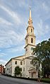
The First Baptist Church in America is the oldest Baptist congregation in America. Founded by Roger Williams in 1638, its present meetinghouse was first occupied in 1775.
-
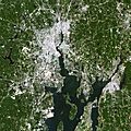
Satellite photograph of greater Providence
-
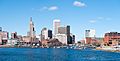
The Providence skyline as viewed from across the Providence River
-
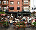
Friday night diners at DePasquale Square, the heart of Providence's Little Italy
-
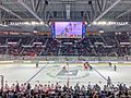
A 2019 hockey game between Providence College and Cornell University at the Dunkin’ Donuts Center
-
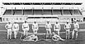
1879 National League champion Providence Grays
-
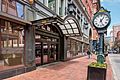
The Shepard Company Building in Downtown Providence's compact urban center
-
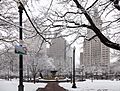
Burnside Park in Downtown Providence facing the city's primary row of high rises
-
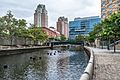
The Providence Riverwalk, at the edge of downtown

.jpg)

_2012.jpg)


See also
 In Spanish: Providence (Rhode Island) para niños
