
Province of Frosinone facts for kids
Quick facts for kids
Province of Frosinone
|
|
|---|---|

Palazzo Gramsci, province headquarters.
|
|

Map with the province of Frosinone, in red, in Italy
|
|
| Country | |
| Region | Lazio |
| Capital | Frosinone |
| Comuni | 91 |
| Area | |
| • Total | 3,247.08 km2 (1,253.70 sq mi) |
| Population
(January 2017)
|
|
| • Total | 493,067 |
| • Density | 151.8494/km2 (393.2880/sq mi) |
| Time zone | UTC+1 (CET) |
| • Summer (DST) | UTC+2 (CEST) |
| Postal code |
03100
|
| Telephone prefix | 0775 |
| Vehicle registration | FR |
| ISTAT | 060 |
| Website | Official website: http://www.provincia.fr.it/ |
The Province of Frosinone (Italian: Provincia di Frosinone) is a province in the Lazio region of Central Italy. Its capital is the city of Frosinone.
Contents
History
The province of Frosinone was created in December of 1926 with territories of the Lazio and Campania regions.
Geography
.svg)
The province of Frosinone has an area of 3,247.08 km2 (1,253.70 sq mi), the third largest province of the Lazio region.
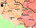
The province is in the southeast of the Lazio region. It borders to the north with the Abruzzo region (L'Aquila province), to the northwest and west with the Metropolitan City of Rome, to the east by the Molise region (Isernia province), to the southeast with the Campania region (Caserta), and to the south with the Latina province.
 |
Rome | L'Aquila province (Abruzzo) | |
|
| Rome | Isernia province (Molise) | |||
| Latina province | Caserta province (Campania) |
The highest mountain in the province is Monte Meta or, simply, La Meta (41°41′20″N 13°56′21″E / 41.68889°N 13.93917°E), with an altitude of 2,242 m (7,356 ft); it is on the border with the L'Aquila province.
The main rivers in the province are the Liri, 120 km (75 mi) long, and its tributary, the Sacco river, 87 km (54 mi) long.
Population
There are 493,067 persons living in the province in 2017, for a population density of 151.8 inhabitants/km².
Evolution of the population in the province of Frosinone

Administration

There are 91 municipalities (or comuni) in the province; they are:
- Acquafondata
- Acuto
- Alatri
- Alvito
- Amaseno
- Anagni
- Aquino
- Arce
- Arnara
- Arpino
- Atina
- Ausonia
- Belmonte Castello
- Boville Ernica
- Broccostella
- Campoli Appennino
- Casalattico
- Casalvieri
- Cassino
- Castelliri
- Castelnuovo Parano
- Castro dei Volsci
- Castrocielo
- Ceccano
- Ceprano
- Cervaro
- Colfelice
- Colle San Magno
- Collepardo
- Coreno Ausonio
- Esperia
- Falvaterra
- Ferentino
- Filettino
- Fiuggi
- Fontana Liri
- Fontechiari
- Frosinone
- Fumone
- Gallinaro
- Giuliano di Roma
- Guarcino
- Isola del Liri
- Monte San Giovanni Campano
- Morolo
- Paliano
- Pastena
- Patrica
- Pescosolido
- Picinisco
- Pico
- Piedimonte San Germano
- Piglio
- Pignataro Interamna
- Pofi
- Pontecorvo
- Posta Fibreno
- Ripi
- Rocca d'Arce
- Roccasecca
- San Biagio Saracinisco
- San Donato Val di Comino
- San Giorgio a Liri
- San Giovanni Incarico
- San Vittore del Lazio
- Sant'Ambrogio sul Garigliano
- Sant'Andrea del Garigliano
- Sant'Apollinare
- Sant'Elia Fiumerapido
- Santopadre
- Serrone
- Settefrati
- Sgurgola
- Sora
- Strangolagalli
- Supino
- Terelle
- Torre Cajetani
- Torrice
- Trevi nel Lazio
- Trivigliano
- Vallecorsa
- Vallemaio
- Vallerotonda
- Veroli
- Vicalvi
- Vico nel Lazio
- Villa Latina
- Villa Santa Lucia
- Villa Santo Stefano
- Viticuso
The largest comune is Veroli, with 119.65 km2 (46.20 sq mi) and the smallest is Vicalvi (8.21 km2 [3.17 sq mi] ). The comune with fewest people living in it is Acquafondata with 263 inhabitants.
Main comuni
The following table shows the 10 comuni with more inhabitants with their population, and their area and altitude.
| No. | Comune | Population (2017) |
Area (km²) |
Density | Altitude (m) |
|---|---|---|---|---|---|
| 1 | Frosinone | 46,120 | 46.85 | 984.4 | 291 |
| 2 | Cassino | 36,460 | 83.42 | 437.1 | 40 |
| 3 | Alatri | 28,884 | 96.96 | 297.9 | 502 |
| 4 | Sora | 26,057 | 72.13 | 361.3 | 300 |
| 5 | Ceccano | 23,494 | 61.06 | 384.8 | 200 |
| 6 | Anagni | 21,411 | 112.82 | 189.8 | 424 |
| 7 | Ferentino | 21,131 | 81.00 | 260.9 | 395 |
| 8 | Veroli | 20,525 | 119.65 | 171.5 | 615 |
| 9 | Pontecorvo | 13,200 | 88.80 | 148.6 | 97 |
| 10 | Monte San Giovanni Campano | 12,847 | 48.71 | 263.7 | 438 |
Gallery


.jpg)

Related pages
- List of communes of the Province of Frosinone
Images for kids
-
Linguistic map of Southern Lazio: Central Italian in pink and Southern Italian (Neapolitan dialects) in magenta.

See also
 In Spanish: Provincia de Frosinone para niños
