Puerto Tejada, Cauca facts for kids
Quick facts for kids
Puerto Tejada, Cauca
|
|||
|---|---|---|---|
|
Municipality and town
|
|||
|
|||

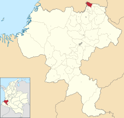
Location of the municipality and town of Puerto Tejada, Cauca in the Cauca Department of Colombia.
|
|||
| Country | |||
| Department | Cauca Department | ||
| Area | |||
| • Municipality and town | 101.1 km2 (39.0 sq mi) | ||
| • Urban | 4.3 km2 (1.7 sq mi) | ||
| Population
(2020 est.)
|
|||
| • Municipality and town | 46,215 | ||
| • Density | 457.12/km2 (1,183.9/sq mi) | ||
| • Urban | 35,821 | ||
| • Urban density | 8,330/km2 (21,580/sq mi) | ||
| Time zone | UTC-5 (Colombia Standard Time) | ||
| Climate | Am | ||
Puerto Tejada (Spanish pronunciation: [ˈpweɾto teˈxaða]) is a town and municipality in the Cauca Department, Colombia.
History
Puerto Tejada was officially made a town on September 17, 1897, in Monte Oscuro (Dark Mountain), named after General Manuel Tejada Sanchez. During the 18th and 19th centuries there had been uprisings of both black slaves and free blacks in the general area, and maroons had established settlements in Monte Oscuro, which provided great cover because of its dense tropical vegetation. After the abolition of slavery in 1852 the former slaves and the maroons' descendants established themselves as organized communities forming family farms that produced coffee, corn, plantain, cassava and cacao. They were joined by settlers and colonists from Antioquia, Valle and the rest of Cauca. There was a thriving agricultural economy at the end of the 19th century and the beginning of the 20th century.
Its first inhabitants settled at the banks of the Palo and Paila rivers. With the creation of the town, other towns surged around the area.
See also
 In Spanish: Puerto Tejada para niños


