
Pulaski County, Arkansas facts for kids
Quick facts for kids
Pulaski County
|
|||
|---|---|---|---|

Pulaski County Courthouse, in downtown Little Rock
|
|||
|
|||

Location within the U.S. state of Arkansas
|
|||
 Arkansas's location within the U.S. |
|||
| Country | |||
| State | |||
| Founded | December 15, 1818 | ||
| Named for | Casimir Pulaski | ||
| Seat | Little Rock | ||
| Largest city | Little Rock | ||
| Area | |||
| • Total | 808 sq mi (2,090 km2) | ||
| • Land | 760 sq mi (2,000 km2) | ||
| • Water | 48 sq mi (120 km2) 5.9%% | ||
| Population
(2020)
|
|||
| • Total | 399,125 | ||
| • Density | 493.97/sq mi (190.72/km2) | ||
| Time zone | UTC−6 (Central) | ||
| • Summer (DST) | UTC−5 (CDT) | ||
| Congressional district | 2nd | ||


Pulaski County is located in the U.S. state of Arkansas with a population of 399,125, making it the most populous county in Arkansas. Its county seat is Little Rock, which is also Arkansas's capital and largest city. Pulaski County is Arkansas's fifth county, formed on December 15, 1818, alongside Clark and Hempstead Counties. The county is named for Casimir Pulaski, a Polish volunteer who saved George Washington's life during the American Revolutionary War. Pulaski County is included in the Little Rock–North Little Rock–Conway, AR Metropolitan Statistical Area which had 731,612 people in the 2015 census estimates. The Little Rock, North Little Rock Combined Statistical Area had 904,469 people in the 2015 census estimates.
Contents
History
An 1863 American Civil War battle, the Battle of Bayou Fourche, occurred in Pulaski County. Pulaski County is also home to Willow Springs Water Park, which is one of the oldest waterparks in the nation, opening in 1928.
-
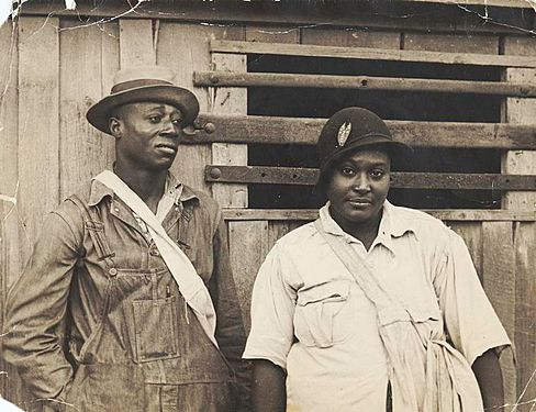
Cotton pickers receiving sixty cents a day ($10.81 in 2017 dollars), Pulaski County, Arkansas, October 1935. Ben Shahn, photographer. From the Farm Security Administration Collection.
.jpg)
Geography
According to the U.S. Census Bureau, the county has a total area of 808 square miles (2,090 km2), of which 760 square miles (2,000 km2) is land and 48 square miles (120 km2) (5.9%) is water.
Major highways
 I-30
I-30 I-40
I-40 I-430
I-430 I-440
I-440 I-530
I-530 I-630
I-630 U.S. Highway 65
 U.S. Highway 67
 U.S. Highway 70
 U.S. Highway 165
 U.S. Highway 167
 Highway 5
 Highway 10
 Highway 100
 Highway 161
 Highway 300
 Highway 338
 Highway 365
 Highway 367
Adjacent counties
- Faulkner County (north)
- Lonoke County (east)
- Grant County (south)
- Jefferson County (south)
- Saline County (west)
- Perry County (northwest)
National protected area
Demographics
| Historical population | |||
|---|---|---|---|
| Census | Pop. | %± | |
| 1830 | 2,395 | — | |
| 1840 | 5,350 | 123.4% | |
| 1850 | 5,657 | 5.7% | |
| 1860 | 11,699 | 106.8% | |
| 1870 | 32,066 | 174.1% | |
| 1880 | 32,616 | 1.7% | |
| 1890 | 47,329 | 45.1% | |
| 1900 | 63,179 | 33.5% | |
| 1910 | 86,751 | 37.3% | |
| 1920 | 109,464 | 26.2% | |
| 1930 | 137,727 | 25.8% | |
| 1940 | 156,085 | 13.3% | |
| 1950 | 196,685 | 26.0% | |
| 1960 | 242,980 | 23.5% | |
| 1970 | 287,189 | 18.2% | |
| 1980 | 340,613 | 18.6% | |
| 1990 | 349,660 | 2.7% | |
| 2000 | 361,474 | 3.4% | |
| 2010 | 382,748 | 5.9% | |
| 2020 | 399,125 | 4.3% | |
| U.S. Decennial Census 1790–1960 1900–1990 1990–2000 2010–2020 2020 |
|||

2020 census
| Race | Number | Percentage |
|---|---|---|
| White (non-Hispanic) | 193,993 | 48.6% |
| Black or African American (non-Hispanic) | 142,139 | 35.61% |
| Native American | 1,169 | 0.29% |
| Asian | 9,933 | 2.49% |
| Pacific Islander | 208 | 0.05% |
| Other/Mixed | 18,530 | 4.64% |
| Hispanic or Latino | 33,153 | 8.31% |
As of the 2020 United States census, there were 399,125 people, 158,000 households, and 93,080 families residing in the county.
Communities

Cities
- Cammack Village
- Jacksonville
- Little Rock (county seat)
- Maumelle
- North Little Rock
- Sherwood
- Wrightsville
Town
Census-designated places
Other communities
Townships
Townships in Arkansas are the divisions of a county. Each township includes unincorporated areas and some may have incorporated towns or cities within part of their space. Townships have limited purposes in modern times. However, the US Census does list Arkansas population based on townships (often referred to as "minor civil divisions"). Townships are also of value for historical purposes in terms of genealogical research. Each town or city is within one or more townships in an Arkansas county based on census maps. Pulaski County only has two townships, as of 2010. They are listed below.
| Township | FIPS code | ANSI code (GNIS ID) |
Population center(s) |
Pop. (2010) |
Pop. density (/mi²) |
Pop. density (/km²) |
Land area (mi²) |
Land area (km²) |
Water area (mi²) |
Water area (km²) |
Geographic coordinates |
|---|---|---|---|---|---|---|---|---|---|---|---|
| Big Rock | 05-90300 | 69013 | Alexander, Cammack Village, Little Rock, Wrightsville | 219,984 | 506.7 | 195.6 | 404.014 | 1,046 | 30.148 | 78.08 | 34°44′30″N 92°24′43″W / 34.741774°N 92.412071°W |
| Hill | 05-91731 | 69014 | Jacksonville, Maumelle, North Little Rock, Sherwood | 162,764 | 435.8 | 168.3 | 355.750 | 921.4 | 17.753 | 45.98 | 34°48′12″N 92°11′32″W / 34.803240°N 92.192098°W |
| Source: U.S. Census Bureau | |||||||||||
Education
- The Pulaski County Special School District is the county's public school district for 729 square miles (1,890 km2) surrounding Little Rock and North Little Rock, which maintain independent districts. Also the Little Rock School District and North Little Rock School District.
- Pulaski Technical College is a two-year community college and technical school that offers seven locations throughout the county, including a flagship campus in western North Little Rock.
- Four-year postsecondary institutions include the University of Arkansas at Little Rock, the University of Arkansas System's only metropolitan campus, the United Methodist Church-affiliated Philander Smith College, Arkansas Baptist College, and the University of Arkansas for Medical Sciences — all located in Little Rock.
Notable people
- Granville Ryles (1831-1909), minister, farmer and state legislator in Arkansas
See also
 In Spanish: Condado de Pulaski (Arkansas) para niños
