
Punta Cana facts for kids
Quick facts for kids
Punta Cana
|
|
|---|---|
 |
Punta Cana, named after a local cape, is a region in the easternmost tip of the Dominican Republic. Covering about 4,200,000 m2 (about 1,100 acres), the region is home to a coastline of sandy white beaches and to a town of the same name. A region once named Punta de Borrachón was merged with Punta Cana by the founding investors in 1969.
Geography and climate
.jpg)
The Punta Cana area has an estimated population of 50,000, with an annual growth rate of 6% as of 2009. To the north, it borders the village and beach of Cabeza de Toro, and the Bávaro and El Cortecito beaches. The nearest city, the 500-year-old Higüey, is 45 kilometres (28 mi) away, which takes about an hour to reach by car. European entrepreneurs, particularly Spanish hotel chains, own all but two of the over 50 megaresorts at the Punta Cana tourism destination.
The province’s 100-kilometre (62 mi) coastline tends to be mildly windy. The ocean waters are mainly shallows, with several natural marine pools in which visitors can bathe without danger. From north to south, the main beaches are Uvero Alto, Macao, Arena Gorda, Bávaro, El Cortecito, Las Corales, and Cabeza de Toro, all north of the cape; and Cabo Engaño, Punta Cana, and Juanillo south of the cape.
Bávaro is the area starting from Cabeza de Toro until Macao Beach. As the hotels started to rise along the east coast, Bavaro itself became a center of services with shopping malls, fast-food stores, drug stores, fine restaurants, banks, clinics, workshops, supermarkets, and schools. The major town in the district is Veron, now bigger than Higüey in territory, a spontaneous – and poor – urban development running along the original road from the west. Verón, last name of the French proprietor of a timberline business in the early 1930s, is now the base-city for hotel workers and related. It has, besides Bávaro, one of only four gas stations in Punta Cana: the next one is located 48 kilometres (30 mi) west in Higüey, at the Fruisa crossroads; a new Texaco gas station opened in April 2010, 3 kilometres (1.9 mi) south of Macao beach; and the new Shell gas station close to the airport (on the highway Coral) opened at the end of 2010.
Climate
Punta Cana features a tropical wet and dry climate under the Köppen climate classification. The weather is fairly consistent all year, with an average temperature of 26 °C (79 °F). The hot and humid season lasts from May to October, and during the day temperatures might reach 35 °C (95 °F). From November to March, temperatures during the evening are around 20 °C (68 °F).
| Climate data for Punta Cana | |||||||||||||
|---|---|---|---|---|---|---|---|---|---|---|---|---|---|
| Month | Jan | Feb | Mar | Apr | May | Jun | Jul | Aug | Sep | Oct | Nov | Dec | Year |
| Record high °C (°F) | 31.0 (87.8) |
30.7 (87.3) |
31.2 (88.2) |
32.0 (89.6) |
33.9 (93.0) |
34.4 (93.9) |
34.7 (94.5) |
34.5 (94.1) |
34.6 (94.3) |
33.7 (92.7) |
32.7 (90.9) |
32.5 (90.5) |
34.7 (94.5) |
| Average high °C (°F) | 27.7 (81.9) |
27.6 (81.7) |
28.1 (82.6) |
28.7 (83.7) |
29.6 (85.3) |
30.3 (86.5) |
30.5 (86.9) |
30.7 (87.3) |
30.9 (87.6) |
30.5 (86.9) |
29.4 (84.9) |
28.1 (82.6) |
29.3 (84.7) |
| Daily mean °C (°F) | 24.8 (76.6) |
24.7 (76.5) |
25.0 (77.0) |
25.5 (77.9) |
26.4 (79.5) |
27.2 (81.0) |
27.5 (81.5) |
27.7 (81.9) |
27.6 (81.7) |
27.0 (80.6) |
26.3 (79.3) |
25.2 (77.4) |
26.2 (79.2) |
| Average low °C (°F) | 21.9 (71.4) |
21.8 (71.2) |
22.0 (71.6) |
22.5 (72.5) |
23.2 (73.8) |
24.1 (75.4) |
24.6 (76.3) |
24.8 (76.6) |
24.4 (75.9) |
23.6 (74.5) |
23.2 (73.8) |
22.3 (72.1) |
23.2 (73.8) |
| Record low °C (°F) | 16.0 (60.8) |
14.0 (57.2) |
14.8 (58.6) |
15.2 (59.4) |
16.0 (60.8) |
14.9 (58.8) |
19.0 (66.2) |
17.9 (64.2) |
15.0 (59.0) |
15.0 (59.0) |
15.9 (60.6) |
14.0 (57.2) |
14.0 (57.2) |
| Average rainfall mm (inches) | 66.4 (2.61) |
54.2 (2.13) |
54.2 (2.13) |
69.2 (2.72) |
124.4 (4.90) |
103.9 (4.09) |
78.3 (3.08) |
103.1 (4.06) |
101.7 (4.00) |
152.1 (5.99) |
116.6 (4.59) |
78.5 (3.09) |
1,102.6 (43.41) |
| Average rainy days (≥ 0.1 mm) | 10.0 | 6.8 | 6.7 | 6.6 | 10.1 | 9.2 | 9.1 | 10.0 | 10.4 | 11.4 | 11.5 | 11.0 | 112.8 |
| Average relative humidity (%) | 82.8 | 81.4 | 81.2 | 82.1 | 83.0 | 82.2 | 82.3 | 82.6 | 82.5 | 83.0 | 82.2 | 83.2 | 82.4 |
| Mean monthly sunshine hours | 256.9 | 241.9 | 278.8 | 265.0 | 249.7 | 255.1 | 268.3 | 271.2 | 245.2 | 242.7 | 238.3 | 233.2 | 3,046.3 |
| Source 1: World Meteorological Organization | |||||||||||||
| Source 2: NOAA | |||||||||||||
Activities and landmarks

Punta Cana is a tourist destination, and the area is a key contributor to tourism in the Dominican Republic.
Many of the excursions in Punta Cana are near the water, it being a beach destination. These activities include snorkeling, windsurfing, banana boat rides, speedboats, scuba diving, catamaran cruises, party boats, deep sea fishing, as well as swimming with dolphins and sharks and stingrays snorkeling. Visitors that prefer to see more of the Dominican country side, there are land based excursions such as safari tours, horse back riding and dune buggy.
Visiting the Dominican Republic's smaller Caribbean islands of Saona and Catalina is a day trip from Punta Cana. The capital city Santo Domingo, and Los Haitises National Park, Samaná, are within a couple of hours. The Basilica Catholic Monument, built in 1962 and designed by two French architects, is in nearby Higüey, the 500-year-old capital of the province.
Images for kids
-
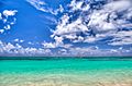
Beach in Punta Cana.
-
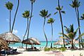
Beach in Punta Cana.
-
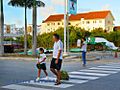
Punta Cana village residential area.
-
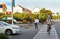
Punta Cana village residential area.
-

Frank Rainieri with his family.
-
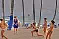
People playing beach volleyball in Punta Cana.
-
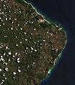
Satellite image of Punta Cana (1999)
-
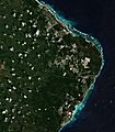
Satellite image of Punta Cana (2018)


See also
 In Spanish: Punta Cana para niños
