
Queanbeyan River facts for kids
Quick facts for kids Queanbeyan River |
|
| Burra Creek, Sallee Creek | |
| Perennial stream | |
 Road bridge carrying the Kings Highway over the Queanbeyan River, in Queanbeyan
|
|
| Name origin: Aboriginal (Ngarigu): "clearwater" | |
| Country | Australia |
|---|---|
| Regions | South Eastern Highlands (IBRA), Monaro, Capital Country |
| Local government areas | Cooma-Monaro, Queanbeyan |
| Part of | Murrumbidgee River, Murray-Darling basin |
| City | Queanbeyan |
| Source | Gourock Range |
| - location | east of Bredbo, New South Wales |
| - elevation | 1,260 m (4,134 ft) |
| - coordinates | 35°56′24″S 149°27′35″E / 35.94000°S 149.45972°E |
| Mouth | confluence with the Molonglo River |
| - location | Oaks Estate, Australian Capital Territory |
| - elevation | 567 m (1,860 ft) |
| - coordinates | 35°20′13″S 149°13′51″E / 35.33694°S 149.23083°E |
| Length | 104 km (65 mi) |
| Basin | 96,000 km² (37,066 sq mi) |
| Reservoirs | Googong Reservoir, Queanbeyan Weir |
Queanbeyan River, a perennial stream in New South Wales, Australia. It is part of the Molonglo catchment. The catchment is in the Murray-Darling Basin. The river is in the Monaro and Capital Country regions of New South Wales. The river is 104 kilometres (65 mi) in length. The river catchment is 96,000 hectares (240,000 acres). The Queanbeyan River and the Cotter River meet the potable water supply needs of the Canberra and Queanbeyan region. The two regions' water quality is protected under federal legislation.
It is said the Aboriginal Ngarigo people used a word that sounded like queanbeyan to name the river. The word meant "clearwater".
Images for kids
-
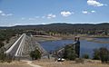
Googong Dam spillway and dam wall
-
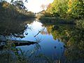
A quiet stretch of the Queanbeyan River near the suspension footbridge, Queanbeyan.


