
Queenton, Queensland facts for kids
Quick facts for kids QueentonCharters Towers, Queensland |
|||||||||||||||
|---|---|---|---|---|---|---|---|---|---|---|---|---|---|---|---|

Bushland, Queenton, 2013
|
|||||||||||||||

Queenton
Location in Queensland
|
|||||||||||||||
| Population | 1,285 (2016 census) | ||||||||||||||
| • Density | 238.0/km2 (616/sq mi) | ||||||||||||||
| Postcode(s) | 4820 | ||||||||||||||
| Area | 5.4 km2 (2.1 sq mi) | ||||||||||||||
| Time zone | AEST (UTC+10:00) | ||||||||||||||
| Location |
|
||||||||||||||
| LGA(s) | Charters Towers Region | ||||||||||||||
| State electorate(s) | Traeger | ||||||||||||||
| Federal Division(s) | Kennedy | ||||||||||||||
|
|||||||||||||||
Queenton is a suburb of Charters Towers in the Charters Towers Region, Queensland, Australia. In the 2016 census Queenton had a population of 1,285 people.
Heritage listings
Queenton has a number of heritage-listed sites, including:
- Enterprise Road: Signals, Crane and Subway, Charters Towers Railway Station
- Charters Towers mine shafts
- Stone kerbing, channels and footbridges of Charters Towers
Education
There are no schools in Queenton. The nearest government primary schools are Millchester State School in neighbouring Millchester to the south, Charters Tower Central State School in neighbouring Charters Towers City to the west, and Richmond Hill State School in neighbouring Richmond Hill to the north. The nearest government secondary school is Charters Towers State High School in Charters Towers City.
Images for kids
-
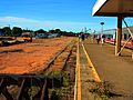
Charters Towers railway station, 2013
-
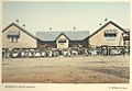
Queenton State School, 1904
.jpg)


All content from Kiddle encyclopedia articles (including the article images and facts) can be freely used under Attribution-ShareAlike license, unless stated otherwise. Cite this article:
Queenton, Queensland Facts for Kids. Kiddle Encyclopedia.