
Quilpie, Queensland facts for kids
Quick facts for kids QuilpieQueensland |
|||||||||||||||
|---|---|---|---|---|---|---|---|---|---|---|---|---|---|---|---|

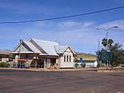
Brolga St, the main street of Quilpie
|
|||||||||||||||

Quilpie
Location in Queensland
|
|||||||||||||||
| Population | 595 (2016 census) | ||||||||||||||
| • Density | 0.033339/km2 (0.08635/sq mi) | ||||||||||||||
| Established | 1917 | ||||||||||||||
| Postcode(s) | 4480 | ||||||||||||||
| Area | 17,847.0 km2 (6,890.8 sq mi) | ||||||||||||||
| Time zone | AEST (UTC+10:00) | ||||||||||||||
| Location |
|
||||||||||||||
| LGA(s) | Shire of Quilpie | ||||||||||||||
| State electorate(s) | Warrego | ||||||||||||||
| Federal Division(s) | Maranoa | ||||||||||||||
|
|||||||||||||||
Quilpie ( KWIL-pee) is a rural town and locality in the Shire of Quilpie, Queensland, Australia. In the 2016 census, Quilpie had a population of 595 people.
The town is the administrative centre of the Quilpie Shire local government area. The town of Toompine is also within the locality.
The economy of the area is based on the grazing and mining industries. The area has one of the largest deposits of boulder opal in the world, and also has extensive deposits of gas and oil.
Contents
Geography
Situated on the banks of the Bulloo River and on the Diamantina Developmental Road, it is 208 kilometres (129 mi) west of Charleville, and 980 kilometres (610 mi) west of the state capital, Brisbane. Quilpie is the administrative centre of the Quilpie Shire, which at the 2006 census had a population of 986. Other townships in the shire include Adavale and Eromanga.
In the 2006 census, Quilpie had a population of 560, a decline from the 2001 census population of 645. Around 14% of the population of Quilpie identity as Aboriginal or Torres Strait Islander and around 1% were born outside Australia.
History
Quilpie was gazetted as a town in 1917 owing to the railway that was laid down from Brisbane. The town is believed to lie on the border of the Bunthamurra and Mardgany Indigenous Australian tribal areas.
The local government centre was previously Adavale within Adavale Shire, but this was moved to Quilpie with the availability of rail transport and the name change to Quilpie Shire. It takes its name from the Indigenous Australian word for stone curlew, quilpeta. The first post office was opened in 1921. Two years later the telephone reached Quilpie and in 1927 the first court house in the town was established.
A fire destroyed a block of the main street in 1926. With no town water the residents watched helplessly. A bore was sunk into the Great Artesian Basin in 1933. It provided drinking water for the town and for a period between 1952 and 1963 the hot water was used to generate electricity for the town.
At the 2006 census, Quilpie had a population of 560.
Flora and fauna
The most common species of trees in the district are:
- Mulga
- Gidgee
- Red river gum
- Bloodwood
- Sandalwood
- Beefwood
There are a large range of animals (including reptiles and insects) that are can be found in the area including:
- Bearded dragon
- Sand goanna (Varanus gouldii) - bungarra in some aboriginal languages
- Black-headed python
- Inland taipan (Oxyuranus microlepidotus) - also known as western taipan and fierce snake
- Mulga snake (Pseudechis australis) - also known as the king brown
- Brolga (Grus rubicunda)
- Emu (Dromaius novaehollandiae)
- Wedge-tailed eagle (Aquila audax)
- Red kangaroo (Macropus giganteus)
- Eastern grey kangaroo (Macropus giganteus)
- Common wallaroo (Macropus robustus)
- Bilby (Macrotis lagotis)
- Water rat (Hydromys chrysogaster)
- Dingo
Facilities and services
Quilpie residents enjoy free access to many amenities including the town library, swimming pool, golf course, museum, sports grounds, an air-conditioned hall and supper room etc. There are well stocked stores and plenty of attractions for visitors with displays of opals and the works of local artists and as well as an information centre. The Brick Hotel has been restored to house displays of opal and art and provide a community learning space.
Climate
Quilpie has a semi-arid climate with hot summers and mild, spring-like winters.
| Climate data for Quilpie | |||||||||||||
|---|---|---|---|---|---|---|---|---|---|---|---|---|---|
| Month | Jan | Feb | Mar | Apr | May | Jun | Jul | Aug | Sep | Oct | Nov | Dec | Year |
| Record high °C (°F) | 47.1 (116.8) |
45.5 (113.9) |
42.9 (109.2) |
38.4 (101.1) |
34.5 (94.1) |
32.1 (89.8) |
29.4 (84.9) |
37.0 (98.6) |
40.1 (104.2) |
43.8 (110.8) |
44.9 (112.8) |
46.1 (115.0) |
47.1 (116.8) |
| Average high °C (°F) | 37.0 (98.6) |
35.6 (96.1) |
33.4 (92.1) |
29.2 (84.6) |
24.0 (75.2) |
20.4 (68.7) |
20.1 (68.2) |
22.7 (72.9) |
27.1 (80.8) |
31.1 (88.0) |
34.0 (93.2) |
36.1 (97.0) |
29.2 (84.6) |
| Average low °C (°F) | 23.8 (74.8) |
23.3 (73.9) |
20.5 (68.9) |
15.7 (60.3) |
10.9 (51.6) |
7.4 (45.3) |
6.1 (43.0) |
7.7 (45.9) |
11.7 (53.1) |
16.1 (61.0) |
19.6 (67.3) |
22.2 (72.0) |
15.4 (59.7) |
| Record low °C (°F) | 13.7 (56.7) |
13.3 (55.9) |
9.6 (49.3) |
3.5 (38.3) |
1.0 (33.8) |
−1.2 (29.8) |
−2.3 (27.9) |
−1.0 (30.2) |
2.1 (35.8) |
5.4 (41.7) |
8.6 (47.5) |
12.3 (54.1) |
−2.3 (27.9) |
| Average precipitation mm (inches) | 52.6 (2.07) |
50.7 (2.00) |
43.3 (1.70) |
24.8 (0.98) |
26.9 (1.06) |
20.0 (0.79) |
16.7 (0.66) |
12.5 (0.49) |
14.0 (0.55) |
21.6 (0.85) |
30.9 (1.22) |
34.5 (1.36) |
348.7 (13.73) |
| Average precipitation days | 4.8 | 4.5 | 3.9 | 2.5 | 2.8 | 2.8 | 2.7 | 2.2 | 2.5 | 3.6 | 4.1 | 4.5 | 40.9 |
Events
- The Pride of the West festival is held in September every year.
- The Quilpie Cup Races
- The Kangaranga Do festival is held in September every year on the Tuesday before the Birdsville Races.
Gallery
-
Quilpie Post Office in 2007
-
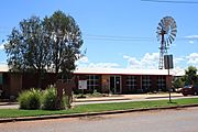
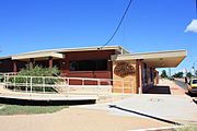
Quilpie Visitors Centre and regional art gallery
-
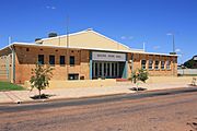
Quilpie Shire Hall
-
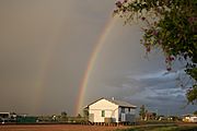
Rainbow over Quilpie - view from behind the Art Gallery
-
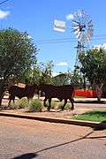
Quilpie public art in the main street
-
Quilpie Public Library
-
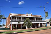
Quilpie Hotel
-
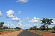
Development Road into Quilpie.
-
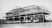
The Imperial Hotel under construction, c.1925
-
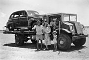
A Brisbane tourist's car being trucked to Quilpie railhead, 1952
-
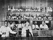
Drinking at the bar of the Quilpie Hotel, c.1921


Economy
The area is wholly devoted to grazing. Boulder opal, oil and gas mining are major secondary industries for the local economy. The majority of the employees of these industries are local residents, with low rates of both unemployment and itinerant work.
Quilpie has one opal mining field; Toompine Field is located between Quilpie and Yowah.
Education
Quilpie State College is a government primary and secondary (Early Childhood-10) school for boys and girls at Cnr Chulungra & Boonkai Streets (26°36′54″S 144°16′17″E / 26.6149°S 144.2714°E). In 2017, the school had an enrolment of 61 students with 12 teachers (11 full-time equivalent) and 12 non-teaching staff (9 full-time equivalent).
For Students wanting to study Year 11 and 12, the closest secondary school is Charleville State High School in Charleville, 208 kilometres (129 mi) to the east. Alternatively, Year 11 and 12 students can also study through the Charleville School of Distance Education or move away to various boarding schools.
St Finbarr's School is a Catholic primary (Prep-6) school for boys and girls at Jabiru Street (26°37′00″S 144°16′12″E / 26.6167°S 144.2701°E). In 2017, the school had an enrolment of 30 students with 5 teachers (3 full-time equivalent) and 5 non-teaching staff (2 full-time equivalent).
Eromanga State School currently operates in the township of Eromanga approximately 90 km west of Quilpie. It has had a chequered history when it was open in the following years – 1897–1908, 1910–1911, 1917–1936, 1967–1981, 1990–present.
Many other public schools have operated in the Quilpie district. The Milo Provisional School was functional between 1888 and 1906. Adavale State School had a long history from 1888 to 1968. Cheepie State School opened in 1915 and closed in 1974. The Toompine Provisional School was open between 1900 and 1902, for a time operating as a half-time school with Duck Creek State School which was open between 1901 and 1905. The Goombie State School operated between 1875 and 1977.
Notable people from Quilpie
- Vaughan Johnson, Queensland state politician
- Ewen Jones, Australian federal politician
- Professor Don Markwell, social scientist and educational leader
- Sandy McPhie, former Queensland state politician
- Justine Saunders, late Australian actor
