RAF Swingfield facts for kids
Quick facts for kids RAF Swingfield
|
|||||||||
|---|---|---|---|---|---|---|---|---|---|
| Wootton, Kent in England | |||||||||
|
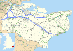
Shown within Kent
|
|||||||||
| Coordinates | 51°09′44″N 001°12′06″E / 51.16222°N 1.20167°E | ||||||||
| Type | Advanced Landing Ground | ||||||||
| Code | IF | ||||||||
| Site information | |||||||||
| Owner | Air Ministry | ||||||||
| Operator | Royal Air Force | ||||||||
| Controlled by | RAF Fighter Command * No. 11 Group RAF |
||||||||
| Site history | |||||||||
| Built | 1944 | ||||||||
| Built by | Royal Engineers Airfield Construction Group | ||||||||
| In use | August 1944 – April 1945 | ||||||||
| Battles/wars | European theatre of World War II | ||||||||
| Airfield information | |||||||||
| Elevation | 140 metres (459 ft) AMSL | ||||||||
|
|||||||||
Royal Air Force Swingfield or more simply RAF Swingfield is a former Royal Air Force Advanced Landing Ground located 5.5 miles (8.9 km) north west of Dover, Kent and 4.5 miles (7.2 km) south of Aylesham, Kent. The airfield was operational between February 1917 and 28 April 1945.
History
The airfield was used by both the Royal Flying Corps and the Royal Air Force opening during February 1917 and closing on 28 April 1945.
Based units
- No. 157 (General Reconnaissance) Wing RAF (August - September 1944)
- No. 119 Squadron RAF flying Fairey Albacores between 9 August 1944 and 2 October 1944
- 819 Naval Air Squadron

All content from Kiddle encyclopedia articles (including the article images and facts) can be freely used under Attribution-ShareAlike license, unless stated otherwise. Cite this article:
RAF Swingfield Facts for Kids. Kiddle Encyclopedia.

