
Rainelle, West Virginia facts for kids
Quick facts for kids
Rainelle, West Virginia
|
|
|---|---|
 |
|
| Motto(s):
"A Town Built to Carry On"
|
|

Location of Rainelle in Greenbrier County, West Virginia.
|
|
| Country | United States |
| State | West Virginia |
| County | Greenbrier |
| Incorporated | April 25, 1913 |
| Government | |
| • Type | City/Town |
| Area | |
| • Total | 1.12 sq mi (2.89 km2) |
| • Land | 1.11 sq mi (2.88 km2) |
| • Water | 0.00 sq mi (0.01 km2) |
| Elevation | 2,405 ft (733 m) |
| Population
(2010)
|
|
| • Total | 1,505 |
| • Estimate
(2019)
|
1,520 |
| • Density | 1,365.68/sq mi (527.34/km2) |
| Time zone | UTC-5 (Eastern (EST)) |
| • Summer (DST) | UTC-4 (EDT) |
| Zip code(s) |
25962
|
| Area code(s) | 304/681 |
| FIPS code | 54-66652 |
| GNIS feature ID | 1555435 |
| Website | http://www.rainelle-wv.com |
Rainelle is a town on the western edge of Greenbrier County, West Virginia, United States. It sits at the base of Sewell Mountain and Sims Mountain, and is bisected by the Meadow River. The only means of transportation to and from Rainelle are roads; primarily US 60 and WV 20, which merge on the western end of the town, and the James River and Kanawha Turnpike, which enters from the south. The population was 1,505 at the 2010 census.
History
Rainelle was named for the Raine family. Thomas and his brother John Raine moved there from Pennsylvania in 1906 to harvest a large stand of hardwoods for building homes, etc. Their Meadow River Lumber Company operated for 60 years, and at one time was the largest hardwood sawmill in the world. In 1970, the owners sold it to Georgia-Pacific Corporation, which tore it down in 1975.
The Midland Trail, now part of U.S. Route 60, runs through the town.
The town was devastated during the 2016 West Virginia flood.
Geography
Rainelle is located at 37°58′11″N 80°46′2″W / 37.96972°N 80.76722°W (37.969639, -80.767210).
According to the United States Census Bureau, the town has a total area of 1.11 square miles (2.87 km2), all of it land. The Meadow River flows through the town in a westerly direction on its way to eventually join the Gauley River.
Demographics
| Historical population | |||
|---|---|---|---|
| Census | Pop. | %± | |
| 1920 | 566 | — | |
| 1930 | 920 | 62.5% | |
| 1940 | 985 | 7.1% | |
| 1950 | 853 | −13.4% | |
| 1960 | 649 | −23.9% | |
| 1970 | 1,826 | 181.4% | |
| 1980 | 1,983 | 8.6% | |
| 1990 | 1,681 | −15.2% | |
| 2000 | 1,545 | −8.1% | |
| 2010 | 1,505 | −2.6% | |
| 2019 (est.) | 1,520 | 1.0% | |
| U.S. Decennial Census | |||
2010 census
As of the census of 2010, there were 1,505 people, 675 households, and 387 families living in the town. The population density was 1,355.9 inhabitants per square mile (523.5/km2). There were 806 housing units at an average density of 726.1 per square mile (280.3/km2). 4The racial makeup of the town was 96.9% White, 0.7% African American, 0.2% Native American, 0.3% Asian, 0.3% from other races, and 1.7% from two or more races. Hispanic or Latino of any race were 0.7% of the population.
There were 675 households, of which 25.9% had children under the age of 18 living with them, 37.6% were married couples living together, 16.0% had a female householder with no husband present, 3.7% had a male householder with no wife present, and 42.7% were non-families. 36.6% of all households were made up of individuals, and 18.8% had someone living alone who was 65 years of age or older. The average household size was 2.14 and the average family size was 2.76.
The median age in the town was 45.3 years. 19.7% of residents were under the age of 18; 6.3% were between the ages of 18 and 24; 23.6% were from 25 to 44; 26.8% were from 45 to 64; and 23.5% were 65 years of age or older. The gender makeup of the town was 44.7% male and 55.3% female.
Notable person
- Rainelle has produced one Major League Baseball player, Cincinnati Reds pitcher Arnold Carter.
Images for kids
-
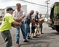
Army National Guard delivers water after a severe storm in 2012

See also
 In Spanish: Rainelle (Virginia Occidental) para niños
