
Ramah, New Mexico facts for kids
Quick facts for kids
Ramah, New Mexico
|
|
|---|---|

Ramah Welcome Sign
|
|

Location of Ramah, New Mexico
|
|

Ramah, New Mexico
Location in the United States
|
|
| Country | United States |
| State | New Mexico |
| County | McKinley |
| Area | |
| • Total | 3.8 sq mi (9.9 km2) |
| • Land | 3.8 sq mi (9.9 km2) |
| • Water | 0.0 sq mi (0.0 km2) |
| Elevation | 6,926 ft (2,111 m) |
| Population
(2000)
|
|
| • Total | 407 |
| • Density | 106.9/sq mi (41.3/km2) |
| Time zone | UTC-7 (Mountain (MST)) |
| • Summer (DST) | UTC-6 (MDT) |
| ZIP code |
87321
|
| Area code(s) | 505 |
| FIPS code | 35-61220 |
| GNIS feature ID | 0909970 |

Ramah (Navajo: Tłʼohchiní – place of wild onions) is a census-designated place (CDP) in McKinley County, New Mexico. The population was 407 at the time of 2000 census and 370 at the 2010 United States Census.
Geography
Ramah is located at 35°8′6″N 108°29′16″W / 35.13500°N 108.48778°W (35.135013, -108.487798). Its altitude is 6,926 feet (2,111 m).
According to the United States Census Bureau, the CDP has a total area of 3.8 square miles (9.8 km2), all of it land.
Surrounding countryside
Ramah was one of fifty locations settled in the New Mexico Territory under the direction of Brigham Young, 2nd President of The Church of Jesus Christ of Latter-day Saints, and is one of only three that still remain today. Ramah was originally settled by Mormon pioneers for the purpose of missionary work to be carried out within the Zuni and Navajo communities. Ramah Lake was built by these same Mormon pioneers in order to farm the surrounding area, which receives little rainfall on a yearly basis. This trait is shared by many areas in the state of New Mexico. In recent years, the lake has mostly dried up, and while fishing was once a popular activity, the environment is now unsustainable.
Ramah lies between the Zuni Indian Reservation, the Ramah Navajo Indian Reservation, and the Cibola National Forest. Wild Spirit Wolf Sanctuary, El Morro National Monument, and El Malpais National Monument are all located near the Ramah area.
Demographics
As of the census of 2000, there were 407 people, 121 households, and 98 families residing in the CDP. The population density was 106.9 people per square mile (41.2/km2). There were 175 housing units at an average density of 46.0 per square mile (17.7/km2). The racial makeup of the CDP was 64.86% White, 25.80% Native American, 0.98% Pacific Islander, 0.74% from other races, and 7.62% from two or more races. Hispanic or Latino of any race were 6.63% of the population.
There were 121 households, out of which 50.4% had children under the age of 18 living with them, 66.9% were married couples living together, 10.7% had a female householder with no husband present, and 18.2% were non-families. 17.4% of all households were made up of individuals, and 8.3% had someone living alone who was 65 years of age or older. The average household size was 3.36 and the average family size was 3.81.
In the CDP, the population was spread out, with 37.6% under the age of 18, 8.8% from 18 to 24, 24.6% from 25 to 44, 18.4% from 45 to 64, and 10.6% who were 65 years of age or older. The median age was 28 years. For every 100 females, there were 115.3 males. For every 100 females age 18 and over, there were 93.9 males.
The median income for a household in the CDP was $25,313, and the median income for a family was $35,278. Males had a median income of $17,143 versus $19,792 for females. The per capita income for the CDP was $10,419. About 23.0% of families and 31.2% of the population were below the poverty line, including 46.8% of those under age 18 and 11.9% of those age 65 or over.
Gallery
-
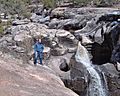
Ramah Falls
-
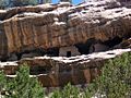
Ancient cliff dwellings in South Ramah
-
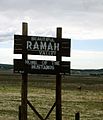
Ramah Welcome Sign


Education
Gallup-McKinley County Schools, the local school district, operates Ramah Elementary School and Ramah Middle/High School in Ramah. Due to an agreement between McKinley County and Cibola County, residents of the Ramah Navajo Indian Reservation are bussed to these schools even though they are physically in Cibola County due to the long distance of the nearest Cibola County schools away from the reservation.
In 1954, a dormitory opened at Ramah Schools, which allowed the majority of residents of the Ramah Navajo Indian Reservation to attend public schools close to their residences. The Ramah Village public high school closed in 1968, due to being condemned. The district also stated that the enrollment was too low. Area secondary students were reassigned to Zuni High School, then in the Gallup-McKinley district. Accordingly the dormitory became restricted only to elementary school students. Ramah Navajo High School opened in the former Ramah High School in 1970; in 1975 it moved to Pinehill, where it became Pine Hill Schools. In 1983 the Ramah Village public high school reopened. In 1995 the combined enrollment of this school and the elementary school in Ramah was fewer than 400.
See also
 In Spanish: Ramah (Nuevo México) para niños
