Randolph County, West Virginia facts for kids
Quick facts for kids
Randolph County
|
|
|---|---|
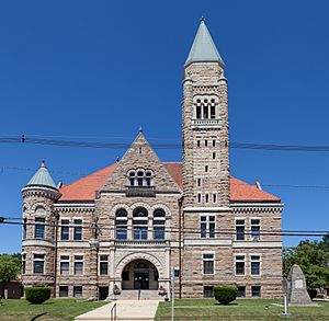
Randolph County Courthouse in Elkins
|
|
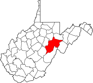
Location within the U.S. state of West Virginia
|
|
 West Virginia's location within the U.S. |
|
| Country | |
| State | |
| Founded | October 16, 1787 |
| Named for | Edmund Jennings Randolph |
| Seat | Elkins |
| Largest city | Elkins |
| Area | |
| • Total | 1,040 sq mi (2,700 km2) |
| • Land | 1,040 sq mi (2,700 km2) |
| • Water | 0.3 sq mi (0.8 km2) 0.03%% |
| Population
(2020)
|
|
| • Total | 27,932 |
| • Density | 26.86/sq mi (10.37/km2) |
| Time zone | UTC−5 (Eastern) |
| • Summer (DST) | UTC−4 (EDT) |
| Congressional district | 2nd |
Randolph County is a county located in the U.S. state of West Virginia. As of the 2010 census, the population was 29,405. Its county seat is Elkins. The county was founded in 1787 and is named for Edmund Jennings Randolph.
Randolph County comprises the Elkins, West Virginia, Micropolitan Statistical Area.
Contents
Geography
According to the U.S. Census Bureau, the county has a total area of 1,040 square miles (2,700 km2), of which 1,040 square miles (2,700 km2) is land and 0.3 square miles (0.78 km2) (0.03%) is water. It is the largest county in West Virginia by area.
Rivers
Mountains
- Point Mountain
- Cheat Mountain
- White Top, a knob of Cheat Mountain
- Laurel Mountain
- Rich Mountain
- Shavers Mountain
- Gaudineer Knob, a knob of Shavers Mountain
Caves and caverns
- Bowden Cave
- Sinks of Gandy
National Natural Landmarks
- Blister Run Swamp
- Gaudineer Scenic Area
- Shavers Mountain Spruce-Hemlock Stand
Major highways
|
Adjacent counties
- Tucker County (northeast)
- Pendleton County (east)
- Pocahontas County (south)
- Webster County (southwest)
- Upshur County (west)
- Barbour County (northwest)
National protected area
- Monongahela National Forest (part)
- United States National Radio Quiet Zone (part)
Demographics
| Historical population | |||
|---|---|---|---|
| Census | Pop. | %± | |
| 1790 | 951 | — | |
| 1800 | 1,826 | 92.0% | |
| 1810 | 2,854 | 56.3% | |
| 1820 | 3,357 | 17.6% | |
| 1830 | 5,000 | 48.9% | |
| 1840 | 6,208 | 24.2% | |
| 1850 | 5,243 | −15.5% | |
| 1860 | 4,990 | −4.8% | |
| 1870 | 5,563 | 11.5% | |
| 1880 | 8,102 | 45.6% | |
| 1890 | 11,633 | 43.6% | |
| 1900 | 17,670 | 51.9% | |
| 1910 | 26,028 | 47.3% | |
| 1920 | 26,084 | 0.2% | |
| 1930 | 25,049 | −4.0% | |
| 1940 | 30,259 | 20.8% | |
| 1950 | 30,558 | 1.0% | |
| 1960 | 26,349 | −13.8% | |
| 1970 | 24,596 | −6.7% | |
| 1980 | 28,734 | 16.8% | |
| 1990 | 27,803 | −3.2% | |
| 2000 | 28,262 | 1.7% | |
| 2010 | 29,405 | 4.0% | |
| 2020 | 27,932 | −5.0% | |
| U.S. Decennial Census 1790–1960 1900–1990 1990–2000 2010–2020 |
|||
2010 census
As of the 2010 United States Census, there were 29,405 people, 11,695 households, and 7,753 families living in the county. The population density was 28.3 inhabitants per square mile (10.9/km2). There were 14,189 housing units at an average density of 13.6 per square mile (5.3/km2). The racial makeup of the county was 97.3% white, 1.2% black or African American, 0.3% Asian, 0.2% American Indian, 0.1% from other races, and 0.8% from two or more races. Those of Hispanic or Latino origin made up 0.7% of the population. In terms of ancestry, 26.3% were German, 15.9% were Irish, 12.0% were English, 10.2% were American, and 5.4% were Italian.
Of the 11,695 households, 27.1% had children under the age of 18 living with them, 51.0% were married couples living together, 10.5% had a female householder with no husband present, 33.7% were non-families, and 28.4% of all households were made up of individuals. The average household size was 2.32 and the average family size was 2.81. The median age was 43.4 years.
The median income for a household in the county was $36,176 and the median income for a family was $47,071. Males had a median income of $34,903 versus $25,988 for females. The per capita income for the county was $18,472. About 12.7% of families and 17.1% of the population were below the poverty line, including 26.1% of those under age 18 and 11.4% of those age 65 or over.
Communities
City
- Elkins (county seat)
Towns
Census-designated places
Unincorporated communities
- Adolph
- Aggregates
- Alpena
- Arnold Hill
- Bemis
- Brady Gate
- Bruxton
- Canfield
- Cassity
- Crystal Springs
- Czar
- Dryfork
- Elkins Junction
- Elkwater
- Ellamore
- Evenwood
- Faulkner
- Glady
- Horton
- Jimtown
- Kerens
- Little Italy
- Mabie
- Mingo
- Monterville
- Newlonton
- Norton
- Osceola
- Pumpkintown
- Read
- Smith Crossing
- Spangler
- Sullivan
- Tigheville
- Upper Mingo
- Weaver
- Whyte
History
Randolph County was part of Virginia until the American Civil War, in which the county was contested in the Western Virginia Campaign. The Battle of Rich Mountain was fought in the county, as was part of the Battle of Cheat Mountain.
Registered historic places
- Beverly Historic District
- Blackman-Bosworth Store
- Butcher Hill Historic District
- Rich Mountain Battlefield
- Tygart Valley Homesteads Historic District
- Albert and Liberal Arts Halls
- Baldwin-Chandlee Supply Company-Valley Supply Company
- Davis Memorial Presbyterian Church
- Davis and Elkins Historic District
- Downtown Elkins Historic District
- Dr. John C. Irons House
- Elkins Milling Company
- Gov. H. Guy Kump House
- Graceland
- Randolph County Courthouse and Jail
- Senator Stephen Benton Elkins House
- Taylor-Condry House
- Warfield-Dye Residence
- Wees Historic District
- West Virginia Children's Home
- Glady Presbyterian Church and Manse
- Day-Vandevander Mill
- Cheat Summit Fort
- E. E. Hutton House
- Tygarts Valley Church
- See-Ward House
- Middle Mountain Cabins
Notable people
- Herman Ball, football player
- Lemuel Chenoweth, master covered bridge builder
- William Wallace Barron, former governor who was indicted for bribery and jury tampering.
- Dellos Clinton "Sheriff" Gainer, major league baseball player
- Marshall Goldberg, football player
- Wilma Lee Cooper Grand Ole Opry and WWVA Jamboree star
- Stoney Cooper, Grand Ole Opry and WWVA Jamboree star
- Eldora Marie Bolyard Nuzum, American newspaper editor and interviewer of U.S. Presidents
See also
 In Spanish: Condado de Randolph (Virginia Occidental) para niños


