
Rangeley, Maine facts for kids
Quick facts for kids
Rangeley, Maine
|
|
|---|---|

View from Bald Mountain
|
|
| Motto(s):
"Maine's Four Season Playground"
|
|

Rangeley, Maine
Location in Maine

Rangeley, Maine
Location in the United States
|
|
| Country | United States |
| State | Maine |
| County | Franklin |
| Incorporated | 1855 |
| Villages | Rangeley Bald Mountain Mooselookmeguntic Mountainview Oquossoc South Rangeley |
| Area | |
| • Total | 55.62 sq mi (144.06 km2) |
| • Land | 41.48 sq mi (107.43 km2) |
| • Water | 14.14 sq mi (36.62 km2) |
| Elevation | 1,614 ft (492 m) |
| Population
(2020)
|
|
| • Total | 1,222 |
| • Density | 30/sq mi (11.4/km2) |
| Time zone | UTC−5 (Eastern (EST)) |
| • Summer (DST) | UTC4 (EDT) |
| ZIP Code |
04970
|
| Area code(s) | 207 |
| FIPS code | 23-61840 |
| GNIS feature ID | 0582690 |
Rangeley is a town in Franklin County, Maine, United States. The population was 1,222 at the 2020 census. Rangeley is the center of the Rangeley Lakes Region, a resort area. The town includes the villages of Rangeley and Oquossoc, as well as the communities of Mooselookmeguntic, Bald Mountain, Mountainview, and South Rangeley.
Contents
History
It is named after an Englishman, Squire James Rangeley, who inherited a 31,000-acre (130 km2) tract bought from Massachusetts in 1796 by his father. He arrived in 1825 to establish an estate based on the English system of landlord and tenants, also giving extensive land to settlers. He built a sawmill, a gristmill, a two-story mansion, and a ten-mile (16 km) road to connect his property with the rest of the world. Rangeley resided here for 15 years, then sold the property and moved to Portland.
Farms produced hay, wheat, oats, barley and potatoes, with cattle grazing the hills. Logging became a principal industry, with booms of logs towed by steamboat across the Rangeley lakes, then guided down rivers in log drives. On March 29, 1855, the town of Rangeley was set off and incorporated from a portion of Rangeley Plantation. By 1870, the population was 313. In 1886, it had twenty dwellings, two hotels, two stores and a post office. Industries included a carriage shop, two blacksmith shops, a boat builder's shop, a sawmill and a shoe shop.
The Phillips and Rangeley Railroad, a narrow gauge common carrier, opened in 1891, becoming part of the Sandy River and Rangeley Lakes Railroad in 1908. Timber and other goods were shipped to markets, and tourists arrived from Boston; Hartford; New York; and Philadelphia. Consequently, the region developed in the 1900s into a seasonal resort area with camps, cabins, summer homes, inns and hotels. The cool mountain climate and abundance of sport fishing made this a highly desirable and exclusive resort destination. Some inhabitants became fishing guides, and among the anglers was President Herbert Hoover. The big hotels would decline, however, with the end of the railroad and invention of the automobile and proliferation of roads leading to vacationers building personal camps. In 1958, The Rangeley Lake House was razed. But smaller motels and camp rentals have taken their place, and Rangeley remains a popular resort.
-
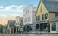
Main Street c. 1915
-
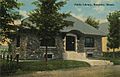
Public Library c. 1912
-
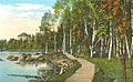
The boardwalk c. 1920


Geography
According to the United States Census Bureau, the town has a total area of 55.62 square miles (144.06 km2), of which 41.48 square miles (107.43 km2) is land and 14.14 square miles (36.62 km2) is water.
Centrally located between the headwaters of both the Androscoggin River and Kennebec River, the town lies on the eastern shores of Rangeley Lake in the Western Maine Mountains. Smalls Falls, lying just south of the town on Route 4, is a popular tourist destination. A sign in town notes that Rangeley is halfway between the Equator and North Pole.
Climate
This climatic region has large seasonal temperature differences, with warm to hot (and often humid) summers and cold (sometimes severely cold) winters. According to the Köppen Climate Classification system, Rangeley has a humid continental climate, abbreviated "Dfb" on climate maps.
| Climate data for Rangeley, Maine | |||||||||||||
|---|---|---|---|---|---|---|---|---|---|---|---|---|---|
| Month | Jan | Feb | Mar | Apr | May | Jun | Jul | Aug | Sep | Oct | Nov | Dec | Year |
| Record high °F (°C) | 55 (13) |
58 (14) |
74 (23) |
83 (28) |
90 (32) |
90 (32) |
90 (32) |
89 (32) |
91 (33) |
77 (25) |
66 (19) |
59 (15) |
91 (33) |
| Average high °F (°C) | 21.7 (−5.7) |
24.8 (−4.0) |
34.0 (1.1) |
47.0 (8.3) |
62.3 (16.8) |
69.5 (20.8) |
74.5 (23.6) |
73.2 (22.9) |
66.4 (19.1) |
51.8 (11.0) |
40.0 (4.4) |
28.4 (−2.0) |
49.4 (9.7) |
| Average low °F (°C) | 2.3 (−16.5) |
3.6 (−15.8) |
12.3 (−10.9) |
25.7 (−3.5) |
38.4 (3.6) |
47.5 (8.6) |
52.5 (11.4) |
50.3 (10.2) |
43.6 (6.4) |
33.0 (0.6) |
23.5 (−4.7) |
11.7 (−11.3) |
27 (−3) |
| Record low °F (°C) | −28 (−33) |
−23 (−31) |
−21 (−29) |
4 (−16) |
21 (−6) |
27 (−3) |
35 (2) |
31 (−1) |
21 (−6) |
13 (−11) |
−1 (−18) |
−21 (−29) |
−28 (−33) |
| Average precipitation inches (mm) | 2.26 (57) |
1.95 (50) |
2.72 (69) |
2.97 (75) |
3.45 (88) |
4.76 (121) |
4.25 (108) |
3.79 (96) |
3.88 (99) |
4.27 (108) |
3.03 (77) |
3.24 (82) |
40.52 (1,029) |
| Average snowfall inches (cm) | 23.5 (60) |
23.7 (60) |
21.5 (55) |
7.6 (19) |
0.3 (0.76) |
0.0 (0.0) |
0.0 (0.0) |
0.0 (0.0) |
0.0 (0.0) |
3.0 (7.6) |
8.5 (22) |
27.0 (69) |
121.6 (309) |
Demographics
| Historical population | |||
|---|---|---|---|
| Census | Pop. | %± | |
| 1860 | 238 | — | |
| 1870 | 313 | 31.5% | |
| 1880 | 563 | 79.9% | |
| 1890 | 616 | 9.4% | |
| 1900 | 961 | 56.0% | |
| 1910 | 1,154 | 20.1% | |
| 1920 | 1,028 | −10.9% | |
| 1930 | 1,472 | 43.2% | |
| 1940 | 1,464 | −0.5% | |
| 1950 | 1,228 | −16.1% | |
| 1960 | 1,087 | −11.5% | |
| 1970 | 941 | −13.4% | |
| 1980 | 1,023 | 8.7% | |
| 1990 | 1,063 | 3.9% | |
| 2000 | 1,052 | −1.0% | |
| 2010 | 1,168 | 11.0% | |
| 2020 | 1,222 | 4.6% | |
| U.S. Decennial Census | |||
2010 census
As of the census of 2010, there were 1,168 people, 575 households, and 338 families residing in the town. The population density was 28.2 inhabitants per square mile (10.9/km2). There were 1,829 housing units at an average density of 44.1 per square mile (17.0/km2). The racial makeup of the town was 98.4% White, 0.5% Asian, 0.6% from other races, and 0.5% from two or more races. Hispanic or Latino of any race were 1.0% of the population.
There were 575 households, of which 19.7% had children under the age of 18 living with them, 47.1% were married couples living together, 7.7% had a female householder with no husband present, 4.0% had a male householder with no wife present, and 41.2% were non-families. Of all households, 34.1% were made up of individuals, and 16.1% had someone living alone who was 65 years of age or older. The average household size was 2.03 and the average family size was 2.56.
The median age in the town was 51.4 years. 16.2% of residents were under the age of 18; 4.8% were between the ages of 18 and 24; 18.1% were from 25 to 44; 35.6% were from 45 to 64; and 25.2% were 65 years of age or older. The gender makeup of the town was 50.8% male and 49.2% female.
Sites of interest
Notable people
- Patrick Dempsey, actor
- Wilhelm Reich, psychiatrist
- Bing Russell, actor
- Kurt Russell, actor
- Arlo West, musician and photographer
See also
 In Spanish: Rangeley (Maine) para niños
