
Rankins Springs facts for kids
Quick facts for kids Rankins SpringsNew South Wales |
|
|---|---|

Mid-Western Highway passing through Rankins Springs
|
|

Rankins Springs
Location in New South Wales
|
|
| Population | 173 (2016 census) |
| Postcode(s) | 2669 |
| Location |
|
| LGA(s) | Carrathool Shire |
| County | Cooper |
| State electorate(s) | Murray |
| Federal Division(s) | Riverina |
Rankins Springs is a village in the Riverina region of New South Wales, Australia in Carrathool Shire and on the Mid-Western Highway. At the 2011 census, Rankins Springs had a population of 299 residents living in 145 private dwellings. The settlement is strung out along the Mid-Western Highway and adjacent railway line. The main agricultural activities of the district around Rankins Springs are the growing of crops such as wheat and oats, and beef-cattle and wool-production.
History
The site of the original township was 10 km north-west of its current location along the Hillston Road. Rankins Springs was established in 1869 around the springs at the foot of the Conapaira Range (from which the township was named). Rankins Springs Post Office opened on 1 September 1875.
References state "the springs were closed in 1957". Nowadays the springs only appear after extensive heavy rain.
The railway reached Rankins Springs in 1923. Passenger service was halted in 1974, and grain freight service was halted in 2004.
The main agricultural activities of the district around Rankins Springs are the growing of crops such as wheat and oats, and beef-cattle and wool-production.
Gallery
-
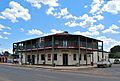
Conapaira Hotel
-
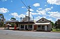
Post office and petrol station
-
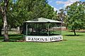
Relocated train station sign
-
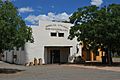
War Memorial Hall


Images for kids
-
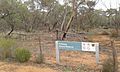
Pulletop Nature Reserve near Rankins Springs.

