
Rapid City, South Dakota facts for kids
Quick facts for kids
Rapid City, South Dakota
|
|
|---|---|
|
City
|
|

View of Rapid City from a nearby hill
|
|
| Nickname(s):
Gateway to the Black Hills, City of Presidents
|
|

Location in Pennington County and the state of South Dakota
|
|

Rapid City, South Dakota
Location in South Dakota

Rapid City, South Dakota
Location in the United States
|
|
| Country | United States |
| State | South Dakota |
| County | Pennington |
| Founded | 1876 |
| Incorporated | February 1883 |
| Area | |
| • City | 54.77 sq mi (141.85 km2) |
| • Land | 54.71 sq mi (141.69 km2) |
| • Water | 0.06 sq mi (0.16 km2) |
| Elevation | 3,202 ft (976 m) |
| Population
(2020)
|
|
| • City | 74,703 |
| • Rank | US: 488th SD: 2nd |
| • Density | 1,416.72/sq mi (546.99/km2) |
| • Urban | 81,251 (US: 352nd) |
| • Metro | 144,558 (US: 299th) |
| Demonym(s) | Rapid Citian |
| Time zone | UTC−7 (Mountain) |
| • Summer (DST) | UTC−6 (Mountain) |
| ZIP Code |
57701–57704, 57709
|
| Area code(s) | 605 |
| FIPS code | 46-52980 |
| GNIS feature ID | 1265333 |
Rapid City (Lakota: Mni Lúzahaŋ Otȟúŋwahe; "Swift Water City") is the second most populous city in South Dakota and the county seat of Pennington County. Named after Rapid Creek, where the settlement developed, it is in western South Dakota, on the Black Hills' eastern slope. The population was 74,703 as of the 2020 Census.
Known as the "Gateway to the Black Hills" and the "City of Presidents" because of the life-size bronze president statues downtown, Rapid City is split by a low mountain ridge that divides the city's western and eastern parts. Ellsworth Air Force Base is on the city's outskirts. Camp Rapid, part of the South Dakota Army National Guard, is in the city's western part.
Rapid City is home to such attractions as Art Alley, Dinosaur Park, the City of Presidents walking tour, Chapel in the Hills, Storybook Island, and Main Street Square. The historic "Old West" town of Deadwood is nearby. In the neighboring Black Hills are the tourist attractions of Mount Rushmore, the Crazy Horse Memorial, Custer State Park, Wind Cave National Park, Jewel Cave National Monument, and the museum at the Black Hills Institute of Geological Research. To the city's east is Badlands National Park.
Contents
History
The public discovery of gold in 1874 by the Black Hills Expedition brought a mass influx of settlers into the Black Hills region of South Dakota. Rapid City was founded, and originally known as "Hay Camp", in 1876 by a group of disappointed miners, who promoted their new city as the "Gateway to the Black Hills." John Richard Brennan and Samuel Scott, with a small group of men, laid out the site of the present Rapid City in February 1876, which was named for the spring-fed Rapid Creek that flows through it. A square mile was measured off and the six blocks in the center were designated as a business section. Committees were appointed to bring in prospective merchants and their families to locate in the new settlement. The city soon began selling supplies to miners and pioneers. Its location on the edge of the Plains and Hills and its large river valley made it the natural hub of railroads arriving in the late 1880s from both the south and east. By 1900, Rapid City had survived a boom and bust and was establishing itself as an important regional trade center for the upper midwest.
Although the Black Hills became a popular tourist destination in the late 1890s, it was a combination of local efforts, the popularity of the automobile, and construction of improved highways that brought tourists to the Black Hills in large numbers after World War I. Gutzon Borglum, already a famous sculptor, began work on Mount Rushmore in 1927 and his son, Lincoln Borglum, continued the carving of the presidents' faces in rock following his father's death in 1941. The work was halted due to pressures leading to the US entry into World War II and the massive sculpture was declared complete in 1941. Although tourism sustained the city throughout the Great Depression of the 1930s, the gasoline rationing of World War II had a devastating effect on the tourist industry in the town, but this was more than made up for by the war-related growth.

The city benefited greatly from the opening of Rapid City Army Air Base, later Ellsworth Air Force Base, an Army Air Corps training base. As a result, the population of the area nearly doubled between 1940 and 1948, from almost 14,000 to nearly 27,000 people. Military families and civilian personnel soon took every available living space in town, and mobile home parks proliferated. Rapid City businesses profited from the military payroll. During the Cold War, missile installations proliferated in the area: a series of Nike Air Defense sites were constructed around Ellsworth in the 1950s. In the early 60s the construction of three Titan missile launch sites containing a total of nine Titan I missiles in the general vicinity of Rapid City took place. Beginning in November 1963, the land for a hundred miles east, northeast and northwest of the city was dotted with 150 Minuteman missile silos and 15 launch command centers, all of which were deactivated in the early 1990s.
In 1949, city officials envisioned the city as a retail and wholesale trade center for the region and designed a plan for growth that focused on a civic center, more downtown parking places, new schools, and paved streets. A construction boom continued into the 1950s. Growth slowed in the 1960s, but the worst natural disaster in South Dakota history, the Black Hills Flood, led to another building boom a decade later. On June 9, 1972, heavy rains caused massive flooding of the Rapid Creek. More than 250 people lost their lives and more than $100 million in property was destroyed.

The devastation of the flood and the outpouring of private donations and millions of dollars in federal aid led to the completion of one big part of the 1979 plan: clearing the area along the Rapid Creek and making it a public park. New homes and businesses were constructed to replace those that had been destroyed. Rushmore Plaza Civic Center and a new Central High School were built in part of the area that had been cleared. The new Central High School opened in 1978, with the graduating class in that year straddling both the original Central (housed in what is now Rapid City High School and community theater) and the new Central. The rebuilding in part insulated Rapid City from the drop in automotive tourism caused by the Oil Embargo in 1974, but tourism was depressed for most of a decade. In 1978, Rushmore Mall was built on the north edge of the city, adding to the city's position as a retail shopping center.
In 1980 in United States v. Sioux Nation of Indians, the Supreme Court of the United States ruled that the Federal government of the United States had illegally stolen the Black Hills from the Sioux people when the government unilaterally broke the treaty that guaranteed the Black Hills belonged to the Sioux. The court decision offered money, but the Sioux declined on principle that the theft of their land should not be validated, and still demand the return of the land. This land includes Rapid City, which is by far the largest modern settlement in the Black Hills. As of 2010, the dispute has not been settled.
In the 1980s, growth was fueled by an increase in tourism, increasingly tied to the Sturgis Motorcycle Rally, followed by another decline in the late 1990s. Fears for the closure of Ellsworth AFB as part of the massive base closure process in the 1990s and 2000s led to attempts to expand other sectors of the economy, but growth continued and the city expanded significantly during this period.
Today, Rapid City is South Dakota's primary city for tourism and recreation. With the approval of a Deep Underground Science and Engineering Laboratory at the Homestake Mine site in nearby Lead, Rapid City has a future of great advancements in technology, medicine, and scientific research.
1972 Rapid Creek flood

On June 9–10, 1972, extremely heavy rains over the eastern Black Hills of South Dakota produced record floods on Rapid Creek and other streams in the area. Nearly 15 inches (380 mm) of rain fell in about 6 hours near Nemo, and more than 10 inches (250 mm) of rain fell over an area of 60 square miles (160 km2). According to the Red Cross, the resulting peak floods (which occurred after dark) left 238 people dead and 3,057 people injured. In addition to the human tragedy, total destruction was estimated in excess of $160 million (about $821 million in 2009 dollars), which included 1,335 homes and 5,000 automobiles that were destroyed. Runoff from this storm produced record floods (highest peak flows recorded) along Battle, Spring, Rapid, and Box Elder Creeks. Smaller floods also occurred along Elk Creek and Bear Butte Creek. Canyon Lake Dam, on the west side of Rapid City, broke the night of the flood, unleashing a wall of water down the creek. The 1972 flooding has an estimated recurrence interval of 500 years, which means that a flood of this magnitude will occur on average once every 500 years. Every year there is a 0.2 percent chance (1 in 500) of experiencing a similar event. To prevent a similar tragedy from occurring in the future, the city's flood plain is no longer allowed to be built upon. Today the flood plain features golf courses, parks, sports arenas, and arboretums where neighborhoods and businesses once stood.
In 2007, the Rapid City Public Library created a 1972 Flood digital archive that collects survivors' stories, photos and news accounts of the flood. The Journey Museum has an interactive display on the 1972 flood which is an ongoing project to give future generations the best idea of how the people were affected and the changes made to it because of the loss of 238 lives. It will in the future include the biographies of all of those who died so they will be remembered as more than names on a memorial.
Geography
Rapid City is located at 44°04′34″N 103°13′42″W / 44.076188°N 103.228299°W. The downtown elevation of Rapid City is 3,202 feet (976 m) and Rapid City sits in the shadow of Black Elk Peak; which at 7,242 feet (2,207 m), is the highest point east of the Rocky Mountains.
According to the United States Census Bureau, the city has a total area of 55.49 square miles (143.71 km2), of which 55.41 square miles (143.5 km2) is land and 0.08 square mile (0.2 km2) is water.
Rapid City is located on the eastern edge of the Black Hills, and is split in half by the Dakota Hogback. Rapid City's "Westside" is located in the Red Valley between the foothills of the Black Hills proper and the Dakota Hogback, so named for the red Spearfish formation soils and the way the valley completely circles the Black Hills. Rapid City has grown up into the foothills, with both ridges and valleys developed, especially in the last 20 years, and wildfire is a distinct threat to these residential areas, as shown by the Westberry Trails fire in 1988.

Skyline Drive follows the summits of the Dakota Hogback south from near Rapid Gap (where Rapid Creek cuts through the Hogback) to a large high plateau which forms the current south edge of Rapid City. The Central and Eastern portions of Rapid City lie in the wide valley of Rapid Creek outside the Hogback, which includes a number of mesas rising a hundred feet or more above the floodplain.
Rapid Creek
Rapid Creek flows through Rapid City, emerging from Dark Canyon above Canyon Lake and flowing in a large arc north of Downtown. Rapid Creek descends to the southeast as the valley widens. The floodplain of Rapid Creek is mostly a series of parks, arboretums, and bike trails, one legacy of the Black Hills Flood of 1972. To the north, a series of ridges separates Rapid Creek from Box Elder Creek, with large older and new residential areas and commercial areas along I-90. To the south, the terrain rises more steeply to the southern widening of the Dakota Hogback into a plateau dividing the Rapid Creek drainage from Spring Creek.
Climate

Rapid City features a steppe climate (Köppen BSk), and is part of USDA Hardiness zone 5a. Its location makes its climate unlike both the higher elevations of the Black Hills and the Great Plains to the east. It is characterized by long arid summers and long dry winters, with short but distinct spring and autumn seasons. Precipitation averages 16.3 inches or 414.0 millimetres annually, but has historically ranged from 9.12 inches or 231.6 millimetres in 1974 to 27.70 inches or 703.6 millimetres in 1946.
Winters are cold and dry, with December, with a daily average temperature of 24.9 °F or −3.9 °C, being the coldest month in recent years; however, chinook winds can warm temperatures above 50 °F or 10 °C, doing so on average about 21 times from December to February. Temperature inversions, however, occasionally produce warmer temperatures in the Black Hills. On average, highs do not climb above freezing on 42 days, while the low temperature reaches 0 °F or −17.8 °C on an average of seventeen nights. Snowfall is frequent but usually not heavy; March and April are typically the snowiest months, and the seasonal total averages 41 inches or 1.04 metres, although historically ranging from 16.9 inches or 0.43 metres during 1980–81 to 80.9 inches or 2.05 metres during 1985–86. Extensive snow cover does not remain for long, with only nine days seasonally with 5 inches or 0.13 metres or more on the ground. Measurable snow has occurred in every month except July.
Compared to locations in the east, spring warms rather gradually, with the last measurable snow typically occurring in late April and precipitation totals beginning to increase; May snow occurs several times per decade. In the latter half of spring, storms typically develop over the Black Hills during the afternoon and move onto the plains in the evening. Only April through June have observed calendar-day precipitation amounts exceeding 3 inches or 76.2 millimetres, and June 15, 1963, with 3.78 inches or 96.0 millimetres, holds the single-day rainfall record; the record-wettest month is May 1996 with 8.18 inches or 207.8 millimetres. However, Rapid City still sees an average of twenty clear to partly cloudy days and 67 percent of its possible sunshine in June. This is the traditional “flood” season for Rapid and other creeks in the Eastern Hills. Temperatures warm rapidly as summer approaches.
Summer in Rapid City is hot, relatively dry, and sunny. July is the warmest month of the year, having a daily average temperature of 87.1 °F (30.6 °C). There is an average of 34 days with 90 °F (32.2 °C)+ highs and 5.1 with 100 °F (37.8 °C)+ highs. Due to the elevation and aridity, lows rarely remain at or above 70 °F (21.1 °C) and during July and August fall to or below 50 °F or 10 °C on an average 7.6 days. Rapid City records an average of nine thunderstorm days in August, but only 1.56 inches or 39.6 millimetres of rain in that month.
Fall is a precipitous transition season, with the average first freeze in Rapid City is October 4 and late August through September in the Black Hills. The Rapid City area’s first snowfall is usually in October, although higher elevations sometimes receive significant snow in September. Occasional cold fronts moving through the area bring blustery northwest winds.
Sunshine is abundant in the region, averaging 2850 hours, 64% of the possible total, per year.
Rapid City holds a record for an extreme temperature drop of 47 °F or 26.1 °C in five minutes on January 10, 1911, from 60 °F or 15.6 °C to 13 °F or −10.6 °C. Official extreme temperatures range from −31 °F or −35.0 °C on February 2, 1996 up to 111 °F or 43.9 °C on July 15, 2006; the record low daily maximum is −18 °F or −27.8 °C on February 2, 1989, while the record high daily minimum is 75 °F or 23.9 °C on July 8, 1985 and July 28, 1960.
| Climate data for Rapid City Regional Airport, South Dakota (1981−2010 normals, extremes 1942−present) | |||||||||||||
|---|---|---|---|---|---|---|---|---|---|---|---|---|---|
| Month | Jan | Feb | Mar | Apr | May | Jun | Jul | Aug | Sep | Oct | Nov | Dec | Year |
| Record high °F (°C) | 76 (24) |
75 (24) |
83 (28) |
93 (34) |
98 (37) |
109 (43) |
111 (44) |
107 (42) |
104 (40) |
96 (36) |
83 (28) |
75 (24) |
111 (44) |
| Mean maximum °F (°C) | 63 (17) |
64 (18) |
74 (23) |
82 (28) |
88 (31) |
95 (35) |
102 (39) |
100 (38) |
95 (35) |
86 (30) |
72 (22) |
61 (16) |
104 (40) |
| Average high °F (°C) | 37.1 (2.8) |
39.6 (4.2) |
47.9 (8.8) |
58.3 (14.6) |
67.8 (19.9) |
77.8 (25.4) |
87.1 (30.6) |
86.4 (30.2) |
75.6 (24.2) |
61.4 (16.3) |
47.0 (8.3) |
36.9 (2.7) |
60.4 (15.8) |
| Average low °F (°C) | 12.9 (−10.6) |
15.1 (−9.4) |
22.9 (−5.1) |
31.8 (−0.1) |
42.1 (5.6) |
51.2 (10.7) |
58.1 (14.5) |
56.6 (13.7) |
46.0 (7.8) |
34.1 (1.2) |
22.1 (−5.5) |
13.0 (−10.6) |
33.9 (1.1) |
| Mean minimum °F (°C) | −8 (−22) |
−7 (−22) |
3 (−16) |
16 (−9) |
28 (−2) |
40 (4) |
48 (9) |
46 (8) |
30 (−1) |
17 (−8) |
3 (−16) |
−10 (−23) |
−18 (−28) |
| Record low °F (°C) | −27 (−33) |
−31 (−35) |
−21 (−29) |
1 (−17) |
18 (−8) |
31 (−1) |
39 (4) |
38 (3) |
18 (−8) |
−2 (−19) |
−19 (−28) |
−30 (−34) |
−31 (−35) |
| Average precipitation inches (mm) | 0.30 (7.6) |
0.44 (11) |
0.93 (24) |
1.80 (46) |
3.22 (82) |
2.53 (64) |
1.85 (47) |
1.56 (40) |
1.29 (33) |
1.42 (36) |
0.53 (13) |
0.42 (11) |
16.29 (414) |
| Average snowfall inches (cm) | 4.4 (11) |
5.8 (15) |
8.7 (22) |
7.9 (20) |
1.1 (2.8) |
0 (0) |
0 (0) |
0 (0) |
0.2 (0.51) |
1.6 (4.1) |
6.0 (15) |
5.4 (14) |
41.1 (104) |
| Average precipitation days (≥ 0.01 in) | 5.4 | 5.7 | 7.6 | 9.5 | 11.7 | 12.3 | 9.5 | 7.7 | 7.0 | 7.2 | 5.3 | 5.4 | 94.3 |
| Average snowy days (≥ 0.1 in) | 5.4 | 5.8 | 5.3 | 4.4 | 0.4 | 0 | 0 | 0 | 0.4 | 1.5 | 4.1 | 5.8 | 33.1 |
| Average relative humidity (%) | 63.5 | 65.1 | 63.8 | 58.6 | 60.8 | 61.9 | 56.2 | 52.6 | 53.5 | 54.2 | 62.2 | 64.8 | 59.8 |
| Mean monthly sunshine hours | 163.5 | 174.0 | 233.9 | 246.9 | 274.3 | 310.5 | 335.5 | 323.8 | 261.9 | 226.0 | 156.6 | 149.9 | 2,856.8 |
| Percent possible sunshine | 57 | 59 | 63 | 61 | 60 | 67 | 72 | 75 | 70 | 66 | 54 | 54 | 64 |
| Source: NOAA (relative humidity and sun 1961−1990) | |||||||||||||
Demographics
| Historical population | |||
|---|---|---|---|
| Census | Pop. | %± | |
| 1880 | 939 | — | |
| 1890 | 2,128 | 126.6% | |
| 1900 | 1,342 | −36.9% | |
| 1910 | 3,454 | 157.4% | |
| 1920 | 5,777 | 67.3% | |
| 1930 | 10,464 | 81.1% | |
| 1940 | 13,844 | 32.3% | |
| 1950 | 25,312 | 82.8% | |
| 1960 | 42,390 | 67.5% | |
| 1970 | 43,846 | 3.4% | |
| 1980 | 46,492 | 6.0% | |
| 1990 | 54,523 | 17.3% | |
| 2000 | 59,607 | 9.3% | |
| 2010 | 67,956 | 14.0% | |
| 2020 | 74,703 | 9.9% | |
| U.S. Decennial Census 2020 Census |
|||
2010 census
As of the census of 2010, there were 67,956 people, 28,586 households, and 16,957 families residing in the city. The population density was 1,226.4 inhabitants per square mile (473.5/km2). There were 30,254 housing units at an average density of 546.0 per square mile (210.8/km2). The racial makeup of the city was 80.4% White, 1.1% African American, 12.4% Native American, 1.0% Asian, 0.1% Pacific Islander, 0.7% from other races, and 4.1% from two or more races. Hispanic or Latino of any race were 4.1% of the population.
There were 28,586 households, of which 29.9% had children under the age of 18 living with them, 41.2% were married couples living together, 13.1% had a female householder with no husband present, 5.1% had a male householder with no wife present, and 40.7% were non-families. 32.9% of all households were made up of individuals, and 11.1% had someone living alone who was 65 years of age or older. The average household size was 2.29 and the average family size was 2.90.
The median age in the city was 35.6 years. 23.9% of residents were under the age of 18; 10.6% were between the ages of 18 and 24; 25.7% were from 25 to 44; 25% were from 45 to 64; and 14.5% were 65 years of age or older. The gender makeup of the city was 49.5% male and 50.5% female.
Art and culture
Because of the importance of tourism in the area, and its extensive market area, Rapid City has many cultural resources usually found only in much larger urban areas. Among these are:
- The Journey Museum
- Museum of Geology
- Dahl Arts Center
- Suzie Cappa Art Center
- The Rapid City Public Library
- Rushmore Plaza Civic Center
- Black Hills Playhouse
- Storybook Island Theater
- Art Alley Gallery
- The Performing Arts Center of Rapid City
- Black Hills Community Theatre
- Black Hills Symphony Orchestra
- Black Hills Chamber Orchestra
- Prairie Edge Art Gallery
- Chapel in the Hills
- Main Street Square
Rapid City also has a large amount of public sculpture on display in many parts of the city. The most visible is "The City of Presidents" – a series of life-sized bronze statues representing each of the American presidents. The statues are located on street corners in the downtown area. Five South Dakota artists created the statues: Edward E. Hlavka, Lee Leuning, John Lopez, James Michael Maher, and James Van Nuys. These statues are being erected by public subscription over a ten-year period between 2000 and 2010.
Sister cities
 Apolda, Germany
 Nikkō, Tochigi, Japan
 Yangshuo County, Guangxi, China
Transportation
Air
Rapid City is a major transportation hub for the Northern Plains. Rapid City Regional Airport provides flights to the airline hub cities of Denver, Minneapolis, Salt Lake City, Dallas-Fort Worth, Las Vegas, Phoenix/Mesa, Houston, Atlanta and Chicago. The airport also has extensive General Aviation operations, including wildfire fighting activities, and medical flight support to Rapid City medical facilities and regional Indian Health Service operations.
Railroad
Historically, Rapid City was served by three railroads. Following extensive restructuring in the industry in the late 20th and early 21st centuries, the city is now served only by the Rapid City, Pierre and Eastern Railroad (RCP&E). In addition to Rapid City, the RCP&E serves the Northern Black Hills and run east to Minnesota and south through Nebraska to connect with major transcontinental railroads Burlington Northern Santa Fe and Union Pacific. Until the 1950s Chicago and Northwestern Railroad ran a daily passenger train from Chicago to Rapid City. Neither South Dakota nor Wyoming have any Amtrak service.
Road
Rapid City's central location on the continent enables it to transport products to both coasts, and points in between. Trucking is a major business activity in the city. Improved connections with Denver and I-80 to the south, via the Heartland Expressway now under construction, will primarily benefit local trucking.
Suburbs
The estimated 2013 population of the Rapid City Metropolitan Statistical Area (Pennington County, Meade County and Custer County) was 141,131. Most cities and towns in the Black Hills and the surrounding plains have a significant percentage of their population who commute to and from Rapid City, and many residents of Rapid City work in outlying towns. Among the nearer suburbs in Pennington and Meade Counties:
- Ashland Heights
- Rapid Valley
- Blackhawk
- Piedmont Valley
- Piedmont
- Box Elder
- Colonial Pine Hills
- Caputa
- Hermosa
- Nemo
- Rimrock Area
- Johnson Siding
- Rockerville
- Summerset
- Whispering Pines
- Moon Meadows
Places of interest
- Dinosaur Park
- Hart Ranch
- Reptile Gardens
- Bear Country USA
- Storybook Island
- South Dakota School of Mines and Technology
- The Journey Museum and Gardens
- Rapid City Public Library
- Rushmore Mall
- Main Street Square
Industry and economy
Rapid City's economy is diverse, but industry is a small portion. Heavy and medium industrial activities include a Portland cement plant (constructed and owned for 84 years by the State of South Dakota and sold in 2003 to Grupo Cementos de Chihuahua, or GCC, a Mexican-based conglomerate); Black Hills Ammunition, an ammunition and reloading supplies manufacturing company; several custom sawmills, a lime plant, a computer peripheral component manufacturing plant, and several farm and ranch equipment manufacturers. Of particular note, this city is the center for the manufacture of Black Hills gold jewelry, a popular product with tourists and Westerners in general. The city is the site of the only American manufacturer of stamping machines used for the labeling of plywood and chipboard products.
Most gold mining has ceased in the Black Hills and was never conducted in or near Rapid City. Regional mining operations include for sand and gravel, as well as the raw materials for lime and Portland cement (including chemical-grade limestone, taconite iron ore, and gypsum) remains an important part of the economy.
The largest sector of the Rapid City economy is government services, including local, state, and federal. Major employers include Ellsworth Air Force Base, home of the 28th Bomb Wing flying the B-1B long-range bomber; the Army National Guard based at Camp Rapid and hosting annual exercises in the Black Hills, drawing troops from five to ten states; and various federal agencies, including the National Park Service, US Forest Service, and Indian Health Service.
Monument Health covers one of the largest geographic service areas in the United States. The health care sector employs more than 8,000 persons in the Rapid City area.
Tourism constitutes a major portion of the Rapid City economy, due to the proximity of Mount Rushmore, Sturgis, home of the Sturgis Motorcycle Rally; Deadwood, and other attractions in the Black Hills. This city provides most services for the Motorcycle Rally. Prepared to satisfy the Rally's demand for motel rooms, camp sites, and other services for tourists during the first week of August, Rapid City has the capacity to host other large events, such as conventions, and numerous associated tourists year-round. Various minor tourist attractions, including wildlife parks, specialty shops, caves, water parks, private museums, and other businesses are found in and near Rapid City.
Other economic sectors include financial service and investing companies such as Waddell and Reed, Citibank, WaMu, Merrill Lynch, and Northwestern Mutual. Rapid City is the headquarters for Assurant Insurance's pre-need division. As noted, the city has a strong medical services sector, and several institutions of higher education. Rapid City is also the major market town for much of five states, drawing commerce from more than half of South Dakota, and large portions of North Dakota, Montana, Wyoming, and the Nebraska Panhandle.
The real compound annual growth rate of the gross domestic product of the Rapid City Metropolitan Statistical Area was 2.6% for 2001–2013.
Sports
Active teams
- The Rapid City Rush is a minor league ice hockey team in the ECHL.
- American Legion Baseball has two teams, Post 22 and Post 320.
- The Expedition League, a summer collegiate baseball league, is headquartered in Rapid City, although no teams currently play there.
Defunct teams
- The Black Hills Posse was a professional basketball club that competed in the International Basketball Association beginning in the 1995–96 season.
- The Black Hills Gold was a professional basketball club that competed in the International Basketball Association during the 1999–2000 season.
- The Rapid City Flying Aces were an indoor football team that competed between 2000 and 2006 in the Indoor Football League, United Indoor Football, and National Indoor Football League, changing names from season to season.
- The Rapid City Thrillers were a professional basketball club that competed in the Continental Basketball Association beginning in the 1987–88 season through the 1996–97 season.
Other teams and events
- Rapid City has two public high schools who field teams that compete in the SDHSAA, as well as two private schools.
- The South Dakota Mines Hardrockers field 13 total varsity sports that compete at the NCAA Division II level in the Rocky Mountain Athletic Conference.
- The Lakota Nation Invitational has been held annually at the Rushmore Plaza Civic Center since 1979.
Education

The Rapid City Public Library is a major resource for education.
Rapid City institutions of higher education include the South Dakota School of Mines and Technology, Oglala Lakota College's He Sapa College Center, Black Hills State University - Rapid City University Center (includes classes and degrees through five other South Dakota post-secondary Institutions), National American University, Western Dakota Technical Institute, Black Hills Beauty College, John Witherspoon College, and several small sectarian preacher training schools.
Black Hills State University is located in nearby Spearfish and offers several classes in Rapid City. A South Dakota State University nurse training program is based in Rapid City.
In 2013, 26.6% of Rapid City residents 25 or older had earned a bachelor's degree or higher. This is on par with the average educational attainment in the United States. The highest rates of educational attainment in South Dakota can be found in metropolitan areas of Rapid City and Sioux Falls.
The local public schools fall under the Rapid City Area Schools school district. There are three high schools within the district: Rapid City Central High School; Stevens High School; and Rapid City High School, which also houses the Performing Arts Center. The middle schools include East, North, South, Southwest, and West. There are 16 elementary schools within the district. These are Black Hawk, Canyon Lake, Corral Drive, General Beadle, Grandview, Horace Mann, Kibben Kuster, Knollwood Heights, Meadowbrook, Pinedale, Rapid Valley, Robbinsdale, South Canyon, South Park, Valley View, and Woodrow Wilson.
There are also various private schools in Rapid City. The city has four Christian high schools: Saint Thomas More, Rapid City Christian High School, Liberty Baptist Academy, and Open Bible Christian School. Rapid City also has various private grade schools, including St. Paul's Lutheran School of the WELS.
Notable people
People who were born or have resided in Rapid City, South Dakota.
- Notable Rapid City people include:
-

Thomas P. Stafford
Air Force officer, test pilot, and NASA astronaut and commander of Apollo 10 -

Neal Tapio,
Trump Presidential Campaign Director,
South Dakota state senator. -
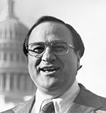
James Abourezk
U.S. Senator & U.S. Representative from South Dakota, First Arab-American U.S. Senator
and
Author, Indian Child Welfare Act. -
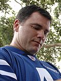
Adam Vinatieri,
NFL Kicker and four-time Super Bowl Champion -
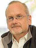
Lawrence Lessig,
Harvard Law School professor, co-founder of the Creative Commons -
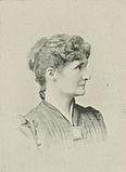
Emily M. Bishop, superintendent of Rapid City public schools, first woman thus honored in the Dakota Territory


.jpg)


- Catherine Bach – Actress, best known as Daisy Duke in The Dukes of Hazzard
- Emily Montague Mulkin Bishop (1858-1916), Delsartean lecturer, instructor, author; elected superintendent of public schools in Rapid City, the first woman thus honored in the Dakota Territory
- Shane Van Boening – Professional billiards player
- Dave Collins – Professional baseball player
- Jessi Combs – Professional car racer and television figure
- Sean Doolittle – Professional baseball player
- Mark Ellis – Professional baseball player
- Meryle Fitzgerald – All-American Girls Professional Baseball League ballplayer
- Jack van der Geest – Holocaust survivor and postwar resident, author of Was God on Vacation?
- Emily Graslie – Correspondent for Chicago Field Museum and YouTube program host
- Dick Green – Professional baseball player
- Bill Groethe – Photographer who took picture of last eight survivors of 1876's Battle of the Little Bighorn
- David Hallberg – Principal dancer with American Ballet Theatre and the Bolshoi Ballet
- Becky Hammon – San Antonio Spurs coach
- John Sherrill Houser – Painter and sculptor
- Carrie Ingalls – Younger sister of author Laura Ingalls Wilder
- Tomi Lahren - Political commentator
- Lawrence Lessig – Harvard Law School professor, co-founder of the Creative Commons
- Randy Lewis - 1980 and 1984 Olympian wrestler and 1984 Olympic freestyle champion at 136.5 lbs
- Eric Piatkowski – NBA player and former Nebraska Cornhusker
- Neal Tapio – 2016 Trump presidential campaign director
- Kelvin Torve– Major League Baseball player for the Minnesota Twins and New York Mets
- Marty Two Bulls Sr – editorial cartoonist
- Adam Vinatieri – NFL kicker for the Indianapolis Colts
- Rosebud Yellow Robe – Native American folklorist, educator and author
Images for kids
-
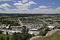
View of the city from Dinosaur Park
-
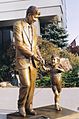
President John F. Kennedy and John Jr., The City of Presidents, Rapid City
-

National Guard officer candidates take part in a tactical road march through a west Rapid City neighborhood.


See also
 In Spanish: Rapid City (Dakota del Sur) para niños
