
Ratanakiri Province facts for kids
Quick facts for kids
Ratanakiri Province
រតនគិរី
|
|
|---|---|

Ratanakiri countryside
|
|

Location of Ratanakiri in Cambodia
|
|
| Country | |
| Established | 17 February 1959 |
| Named for | Khmer: រតនៈ (gem) + គិរី (mountain) |
| Capital | Banlung Municipality |
| Area | |
| • Total | 10,782 km2 (4,163 sq mi) |
| Population
(2019)
|
|
| • Total | |
| • Density | 19/km2 (50/sq mi) |
| Time zone | UTC+7 (ICT) |
Ratanakiri is a province in Cambodia. The capital city is Banlung. Ratanakiri Province was created in 1959 from land that had been the eastern area of Stung Treng Province.
The Annamite Range of mountains is in the north. There are the Tonle San and Tonle Srepok rivers. Lomphat Wildlife Sanctuary and Virachey National Park are both in the province.
There are 8 districts and 1 municipality:
- Andoung Meas
- Banlung Municipality
- Bar Kaev
- Koun Mom
- Lumphat
- Ou Chum
- Ou Ya Dav
- Ta Veaeng
- Veun Sai
Images for kids
-
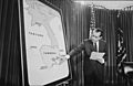
U.S. president Richard Nixon (shown here discussing Cambodia at a 1970 press conference) authorized the covert 1969–1970 bombing of Vietnamese targets in Ratanakiri.
-
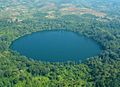
Aerial view of Yak Loum, a crater lake near Banlung
-
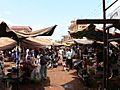
A local market in Banlung
-
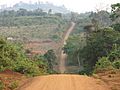
A road in rural Ratanakiri
-
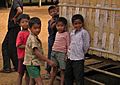
Tampuan children in Ratanakiri Province
-
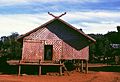
Meeting house in a Kreung village near Banlung


.jpg)


See also
 In Spanish: Provincia de Ratanak Kirí para niños
